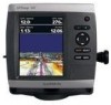
Garmin GPSMAP 541s Owner's Manual - Page 53
Setting the Total Fuel Onboard Alarm, Configuring My Boat, Setting Weather Alarms
 |
UPC - 753759096045
View all Garmin GPSMAP 541s manuals
Add to My Manuals
Save this manual to your list of manuals |
Page 53 highlights
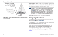
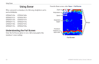
Setting Weather Alarms Note: You must have a subscription to XM WX Weather and a connected Garmin XM WX weather receiver to view weather information (page 60). 1. From the Home screen, select Configure > Alarms > Weather. 2. Turn the following alarms on or off: marine, tornado, severe storm, flood, or flash flood. Setting the Total Fuel Onboard Alarm You can configure your chartplotter to sound an alarm when the total amount of remaining onboard fuel reaches the specified level. To receive fuel-level information, your unit must be connected to an external fuel sensor, such as the Garmin GFS 10. To enable the Total Fuel Onboard alarm and set the fuel alarm level: 1. From the Home screen, select Configure > Alarms > Fuel > Total Onboard > On (or Off). 2. If you select On, use the Rocker to indicate the fuel level at which the alarm should sound. Configuring the Chartplotter Configuring My Boat To configure settings for your boat, from the Home screen, select Configure > My Boat. Keel Offset-offset the surface reading for the depth of a keel, making it possible to measure depth from the bottom of the keel instead of from the transducer location. Enter a positive number to offset for a keel. Enter a negative number to compensate for a large vessel that may draw several feet of water. To adjust the Keel Offset: 1. From the Home screen, select Configure > My Boat > Keel Offset. 2. Use the Rocker to enter the measured distance from the transducer location to the water line or to the keel of the boat. • If you are measuring down to the keel (transducer installed at the water line), enter a (+) positive number. This shows the depth at the bottom of the keel. • If you are measuring up to the water line (transducer installed on the bottom of the keel), enter a (-) negative number. This shows the depth at the surface. 3. Select Done to accept the number. GPSMAP 400/500 Series Owner's Manual 47
-
 1
1 -
2
-
3
-
4
-
5
-
6
-
7
-
8
-
9
-
10
-
11
-
12
-
13
-
14
-
15
-
16
-
17
-
18
-
19
-
20
-
21
-
22
-
23
-
24
-
25
-
26
-
27
-
28
-
29
-
30
-
31
-
32
-
33
-
34
-
35
-
36
-
37
-
38
-
39
-
40
-
41
-
42
-
43
-
44
-
45
-
46
-
47
-
 48
48 -
 49
49 -
 50
50 -
 51
51 -
 52
52 -
 53
53 -
 54
54 -
 55
55 -
 56
56 -
 57
57 -
 58
58 -
59
-
60
-
61
-
62
-
63
-
64
-
65
-
66
-
67
-
68
-
69
-
70
-
71
-
72
-
73
-
74
-
75
-
76
-
77
-
78
-
79
-
80
-
81
-
82
-
83
-
84
-
85
-
86
-
87
-
88
 |
 |