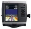
Garmin GPSMAP 541s Owner's Manual - Page 84
GPSMAP 400/500 Series Owner's Manual, Points of Interest POI
 |
UPC - 753759096045
View all Garmin GPSMAP 541s manuals
Add to My Manuals
Save this manual to your list of manuals |
Page 84 highlights
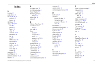
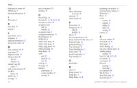
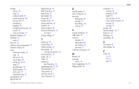
Index high-pressure center 64 HOME key 5 hurricane information 63 I ID number 6 K keel offset 47 keypad 5 L Lane Width 16, 18 Language 42 lightning information 62 low-pressure center 64 M man overboard 29, 57 map datum 42 MapSource data 37 Mariner's Eye 3D AIS 26 MARPA 26 mariner's eye 3D colors 17 mark current location 29 MARPA threats 26 MENU key 5 messages 71 78 move a waypoint 29 My Boat 47 N Navaid Type 14 Navigate To 11, 28, 30, 31, 58 Navigation Alarms 45 navigation chart AIS 26 MARPA 26 navigation charts 8 navigation preferences 42 New Waypoint 16 NEXRAD 61 NMEA 0183 Setup 44 NMEA 2000 Setup 45 NMEA High Speed 44 NMEA Standard 44 Noise Reject 54 north grid 42 magnetic 42 true 42 north up 13 No Zoom 54 numbers customizing 34 overlay numbers 10 viewing 34 O object information accessing 12 odometer 35 Other Vessels 48 P Pause Sonar 53 Perspective 3D 15 AIS 26 MARPA 26 photos 12 physical specifications 69 Points of Interest (POI) 14, 21, 33 Position Format 42 position tracking 57 Posn. Precision 45 Power/Backlight key 5 power source 70 product registration iv Proj. Heading 25 Q quick links i R radio 55 Range (sonar) 54 Range keys 5 Range Rings 16, 18 registering your product iv restoring factory settings 6 Rocker key 5 Roses 12 routes creating 30 deleting 31 editing 31 labels 42 viewing 37 route to 27 S safe-zone settings 49 Safe Depth 18, 43 Safe Height 43 Safety Shading 14 safe zone collision alarm 26 satellite imagery enabling 19 Save To Card 38, 39, 41 screenshots 74 scroll speed 52 SD cards inserting 6 removing 6 sea conditions 66 SELECT key 5 Serial Port setup 44 Service Points 12 GPSMAP 400/500 Series Owner's Manual
-
 1
1 -
2
-
3
-
4
-
5
-
6
-
7
-
8
-
9
-
10
-
11
-
12
-
13
-
14
-
15
-
16
-
17
-
18
-
19
-
20
-
21
-
22
-
23
-
24
-
25
-
26
-
27
-
28
-
29
-
30
-
31
-
32
-
33
-
34
-
35
-
36
-
37
-
38
-
39
-
40
-
41
-
42
-
43
-
44
-
45
-
46
-
47
-
48
-
49
-
50
-
51
-
52
-
53
-
54
-
55
-
56
-
57
-
58
-
59
-
60
-
61
-
62
-
63
-
64
-
65
-
66
-
67
-
68
-
69
-
70
-
71
-
72
-
73
-
74
-
75
-
76
-
77
-
78
-
 79
79 -
 80
80 -
 81
81 -
 82
82 -
 83
83 -
 84
84 -
 85
85 -
 86
86 -
 87
87 -
 88
88
 |
 |