Garmin GPSMAP 541s Owner's Manual - Page 83
Index
 |
UPC - 753759096045
View all Garmin GPSMAP 541s manuals
Add to My Manuals
Save this manual to your list of manuals |
Page 83 highlights
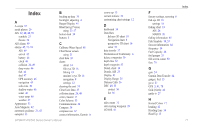
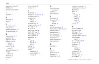
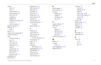
Index A A-scope 52 aerial photos 20 AIS 22, 40, 48, 59 symbols 23 threats 26 AIS Alarm 49 alarms 45, 71-74 AIS 49 arrival 45 battery 46 clock 46 collision 26, 49 deep water 46 fish 46 fuel 47 GPS accuracy 46 navigation 45 safe-zone 49 shallow water 46 sonar 46 water temp 46 weather 47 Appearance 53 Auto Magnetic 42 automatic guidance 21, 43 autopilot 33 B backing up data 39 backlight, adjusting 4 Beeper/Display 41 BlueChart g2 Vision using 33-37 bottom lock 54 buttons 5 C Calibrate Water Speed 48 Chart/Sonar screen using 21 chart data 10 charts detail 14 fish eye 3D 18 fishing 19 mariner's eye 3D 16 navigation 8 settings 12 cleaning the unit 74 Clear User Data 37 collision alarm 26, 49 colors, hazard 17 Color Scheme 53 Communications 44 Compass 34 compass rose 12 contact information, Garmin iv GPSMAP 400/500 Series Owner's Manual course up 13 current stations 36 customizing chart settings 12 D dashboard 34 Data Bars fish eye 3D chart 18 Navigation chart 9 perspective 3D chart 16 sonar 53 data transfer 37 Declaration of Conformity iv delete a waypoint 30 depth line 52 depth waypoint 53 Detail, chart 14 Details, AIS 25 Display 41 Display Range 25 Distress Calls 56 DSC 49, 55 contact 56 list 56 E edit a route 31 edit existing waypoint 29 EGNOS 41 F factory settings, restoring 6 fish eye 3D 18 settings 18 fishing chart 19 AIS 26 MARPA 26 fishing information 65 Fish Symbols 18, 53 forecast information 64 frequency 54 Fuel Capacity 48 fuel gauges 35 full screen, sonar 50 fuse 70 G gain 54 Garmin Data Transfer 44 gauges, fuel 35 go to 27 GPS 5, 41, 70 Grid (North) 42 guide to 27 H Hazard Colors 17 heading 42 Heading Line 14 Head Up 13 Index 77
-
 1
1 -
2
-
3
-
4
-
5
-
6
-
7
-
8
-
9
-
10
-
11
-
12
-
13
-
14
-
15
-
16
-
17
-
18
-
19
-
20
-
21
-
22
-
23
-
24
-
25
-
26
-
27
-
28
-
29
-
30
-
31
-
32
-
33
-
34
-
35
-
36
-
37
-
38
-
39
-
40
-
41
-
42
-
43
-
44
-
45
-
46
-
47
-
48
-
49
-
50
-
51
-
52
-
53
-
54
-
55
-
56
-
57
-
58
-
59
-
60
-
61
-
62
-
63
-
64
-
65
-
66
-
67
-
68
-
69
-
70
-
71
-
72
-
73
-
74
-
75
-
76
-
77
-
 78
78 -
 79
79 -
 80
80 -
 81
81 -
 82
82 -
 83
83 -
 84
84 -
 85
85 -
 86
86 -
 87
87 -
 88
88
 |
 |
