Garmin RINO 520 Owner's Manual - Page 50
Pan Plot, Resetting Data, To use the Pan Plot option, To reset the elevation data and max elevation
 |
UPC - 753759049072
View all Garmin RINO 520 manuals
Add to My Manuals
Save this manual to your list of manuals |
Page 50 highlights
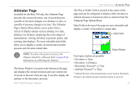
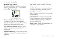
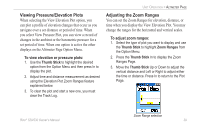
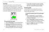
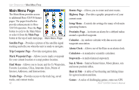
Unit Operation > Altimeter Page Pan Plot The Pan Plot option allows you to scroll through the stored elevation or pressure profile and to view a single point along the profile. When the pointer is stopped at a location along the profile, the display shows the elevation, time of day and date the point was created. The most recent data is displayed on the right side of the plot. As the profile moves past the pointer, the status window at the top of page changes to display the date, time, and altitude for the point indicated. Resetting Data You can reset the elevation data and the maximum elevation data by selecting the Reset option from the Altimeter Page Option Menu. Pan Plot Option Page To use the Pan Plot option: 1. Use the Thumb Stick to access the Option Menu. 2. Highlight the View Points option and press the Thumb Stick In to display the View Points Page. 3. Move the Thumb Stick Right or Left to scroll the profile past the pointer in the center of the page. To reset the elevation data and max elevation fields: 1. Use the Thumb Stick to highlight the Reset option from the page Option Menu and press it In to display the Reset page. 2. Use the Thumb Stick to highlight the elevation options on the page and then press it In to place a check mark in the box next to a selected item. 3. Move to the Apply button and press the Thumb Stick In to reset the data fields. 40 Rino® 520/530 Owner's Manual
-
 1
1 -
2
-
3
-
4
-
5
-
6
-
7
-
8
-
9
-
10
-
11
-
12
-
13
-
14
-
15
-
16
-
17
-
18
-
19
-
20
-
21
-
22
-
23
-
24
-
25
-
26
-
27
-
28
-
29
-
30
-
31
-
32
-
33
-
34
-
35
-
36
-
37
-
38
-
39
-
40
-
41
-
42
-
43
-
44
-
 45
45 -
 46
46 -
 47
47 -
 48
48 -
 49
49 -
 50
50 -
 51
51 -
 52
52 -
 53
53 -
 54
54 -
 55
55 -
56
-
57
-
58
-
59
-
60
-
61
-
62
-
63
-
64
-
65
-
66
-
67
-
68
-
69
-
70
-
71
-
72
-
73
-
74
-
75
-
76
-
77
-
78
-
79
-
80
-
81
-
82
-
83
-
84
-
85
-
86
-
87
-
88
-
89
-
90
-
91
-
92
-
93
-
94
-
95
-
96
-
97
-
98
-
99
-
100
-
101
-
102
-
103
-
104
-
105
-
106
-
107
-
108
-
109
-
110
-
111
-
112
-
113
-
114
-
115
-
116
-
117
-
118
-
119
-
120
-
121
-
122
-
123
-
124
-
125
-
126
-
127
-
128
-
129
-
130
-
131
-
132
 |
 |
