Magellan eXplorist 300 Manual - English
Magellan eXplorist 300 Manual
 |
UPC - 763357109382
View all Magellan eXplorist 300 manuals
Add to My Manuals
Save this manual to your list of manuals |
Magellan eXplorist 300 manual content summary:
- Magellan eXplorist 300 | Manual - English - Page 1
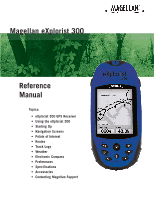
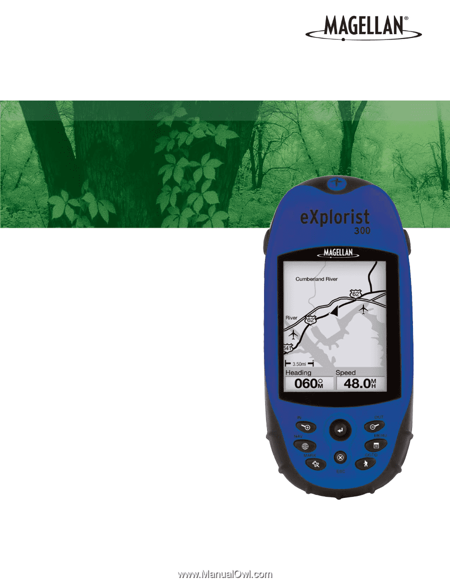
Magellan eXplorist 300 Reference Manual Topics: • eXplorist 300 GPS Receiver • Using the eXplorist 300 • Starting Up • Navigation Screens • Points of Interest • Routes • Track Logs • Weather • Electronic Compass • Preferences • Specifications • Accessories • Contacting Magellan Support - Magellan eXplorist 300 | Manual - English - Page 2
of Defense civil GPS user policy and the Federal Radionavigation Plan. Accuracy can also be affected by poor satellite geometry and obstructions, such as buildings and large trees. USE PROPER ACCESSORIES Use only Magellan cables and antennas; the use of non-Magellan cables and antennas may - Magellan eXplorist 300 | Manual - English - Page 3
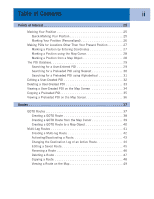
Table of Contents i eXplorist 300 GPS Receiver 1 Features of the Magellan eXplorist GPS receiver 1 Button Descriptions 2 Installing the Batteries 4 Using the eXplorist 300 5 Going to a Destination 5 Saving Your Position 6 Tracing Your Steps 7 Additional Features 8 Summary 8 Starting Up - Magellan eXplorist 300 | Manual - English - Page 4
Nearest 30 Searching for a Preloaded POI using Alphabetical 31 Editing a User-Created POI 32 Deleting a User-Created POI 33 Viewing a User-Created POI on the Map Screen 34 Copying a Preloaded POI 35 Viewing a Preloaded POI on the Map Screen 36 Routes 37 GOTO Routes 37 Creating a GOTO Route - Magellan eXplorist 300 | Manual - English - Page 5
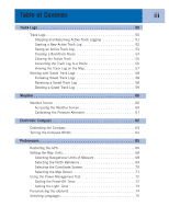
63 Turning the Compass Off/On 64 Preferences 65 Restarting the GPS 66 Setting the Map Units 68 Selecting Navigational Units of Measure 68 Selecting the North Reference 69 Selecting the Coordinate System 70 Selecting the Map Datum 71 Using the Power Management Tool 72 Setting the Power - Magellan eXplorist 300 | Manual - English - Page 6
iv Clearing Memory 76 Clearing All Track Logs 76 Clearing All User-Entered POIs and Routes 77 Clearing All Routes 77 Clearing All Track Logs, User-Entered POIs, and Routes 77 Reseting the eXplorist to Factory Defaults 78 Specifications 79 Accessories 81 Contacting Magellan Support 82 - Magellan eXplorist 300 | Manual - English - Page 7
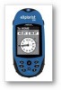
• 3 meter accuracy (WAAS/EGNOS) • Multiple track logs • Stores up to 500 points of interest and 20 routes • Pocket-sized and waterproof to IPX-7 Antenna Display Backlight Button Power Button Arrow Joystick ENTER ZOOM IN NAV MARK ZOOM OUT MENU GOTO ESCAPE eXplorist 300 GPS Receiver (front) - Magellan eXplorist 300 | Manual - English - Page 8
eXplorist 300 GPS Receiver 2 Button Descriptions: Power Backlight ENTER ESCAPE ZOOM IN ZOOM OUT MENU NAV MARK GOTO Arrow joystick Turns the eXplorist on or off. Turns the display backlight on. Sequences from off to low to high intensity. Used to access highlighted menu items or accept highlighted - Magellan eXplorist 300 | Manual - English - Page 9
eXplorist 300 GPS Receiver Wrist Lanyard Strap Mounting Hole Battery Door 3 Battery Door Fastener (Unscrew to open battery door to install batteries.) eXplorist 300 GPS Receiver (back) - Magellan eXplorist 300 | Manual - English - Page 10
eXplorist 300 GPS Receiver 4 Installing the Batteries The eXplorist 300 uses two AA batteries that to the last viewed navigation screen. Setting the Light Timer From any Nav screen press MENU. Highlight Preferences and press ENTER. Highlight Pwr Management and press ENTER. Use the down arrow - Magellan eXplorist 300 | Manual - English - Page 11
The basic operation of your eXplorist is to use the GPS satellites to compute your present position. This is done internally in the software of your eXplorist. The only thing that you need to do is to give your eXplorist a clear view of the sky so that it can receive the signals from the satellites - Magellan eXplorist 300 | Manual - English - Page 12
these instructions exactly. To compensate for that, your eXplorist automatically updates the route, providing you with up-to-date information about getting to your destination. GOTO routes are the simplest and most commonly used feature of your eXplorist 300. With just the GOTO button the eXplorist - Magellan eXplorist 300 | Manual - English - Page 13
eXplorist compute your position. (Make sure that you have a clear view of the sky.) Using the MARK button what the eXplorist does. It saves the computed positions as hidden points of interest Now, press MENU, highlight BackTrack and press ENTER. Your eXplorist will now seamlessly guide you along - Magellan eXplorist 300 | Manual - English - Page 14
Using the eXplorist 300 8 Additional Features Your Magellan eXplorist contains all of the features you would expect from a high-quality Magellan-brand handheld navigation device, as well as many more to make your outdoor experience more enjoyable. You have the ability to customize the - Magellan eXplorist 300 | Manual - English - Page 15
displayed. You have approximately 30 seconds between pressing the POWER button and pressing the ENTER button, otherwise the eXplorist will automatically turn itself off. Turning the eXplorist Off To turn the eXplorist off, press the POWER button on the top right side. There is a 5-second countdown - Magellan eXplorist 300 | Manual - English - Page 16
press the NAV button until the Satellite Status screen is displayed. Press MENU. Use the Svenska assume full responsibility and risk when using this device. PRESS TO AGREE Press ENTER to continue. cold start. Normally, when you first turn the eXplorist on it will compute your position in a matter - Magellan eXplorist 300 | Manual - English - Page 17
update, and you will be 3D Position Fix able to graphically see how well your eXplorist is performing. Tracking 7.... When the eXplorist has enough information to compute a position fix, the Satellite Status screen is replaced with the Map the ENTER button. Enter Coord USA Americas Europe Asia - Magellan eXplorist 300 | Manual - English - Page 18
date, press ENTER. Accept Information. The Done button is highlighted at the bottom of the display. Review the information you entered; if correct, press ENTER view of the sky. As before, when the eXplorist computes the initial position, the Map screen will be displayed, with your computed position - Magellan eXplorist 300 | Manual - English - Page 19
initial startup procedure for the Magellan eXplorist 300. Once the Map screen is displayed, you have successfully initialized the eXplorist and are ready to go. Now would be a good time to familiarize yourself with the different navigation screens (using the NAV button) and to set any preferences - Magellan eXplorist 300 | Manual - English - Page 20
.563W Elevation 1292 FT Accuracy 25 FT Date/Time 01 FEB 04 03:30:36 PM Trip Odometer Battery 0000.0 M I 3D Position Fix Tracking 7.... ESC ESC NAV NAV Tip: The ESC button will also set through the navigation screens, just like the NAV button but in the reverse order. Map Screen The first - Magellan eXplorist 300 | Manual - English - Page 21
210 San Dimas ent vina 10 10 1.60mi Heading Speed 352 o M 4.3 M H Position Cursor Pan Cursor (used when in Cursor Mode) Hourglass (used when position is unknown and eXplorist is trying to compute the position) Data Field 2 Changing Map Scale Press the Zoom In or the Zoom Out buttons - Magellan eXplorist 300 | Manual - English - Page 22
may want to display more of the map and may not need this information. The eXplorist gives you the capability to turn this information on or off. 1. While viewing the Map screen, press MENU. 2. With Hide Map Info or Show Map Info highlighted, press ENTER. Glendora 210 San Dimas ent vina 10 10 - Magellan eXplorist 300 | Manual - English - Page 23
• Elevation • Time • Date To customize the map information: 1. While viewing the Map screen, press MENU. 2. Use the Arrow joystick to highlight Customize displayed is chosen, press ESC to exit the customize function. Customize page GleBndeoararing D2i1s0tance San Dimas Speed Heading ent - Magellan eXplorist 300 | Manual - English - Page 24
right corner of the display. This arrow points in the direction of true north. To change the map orientation: 1. While viewing the Map screen, press MENU. 2. Use the Arrow joystick to highlight Map Setup. 3. Press ENTER. 4. Use the Arrow joystick to highlight the Orientation field. 5. Press - Magellan eXplorist 300 | Manual - English - Page 25
more easily, depending on where you are navigating. To change the primary usage: 1. While viewing the Map screen, press MENU. 2. Use the Arrow joystick to highlight Map Setup. 3. Press ENTER. 4. Use the Arrow joystick to highlight the Primary Usage field. 5. Press ENTER. 6. Use the Arrow joystick - Magellan eXplorist 300 | Manual - English - Page 26
provides an easy-to-use graphical compass that should be familiar to most GPS users. Highlights of the Compass screen: • With an active route, the top of the Compass screen displays the name of the destination. • Press MENU and select Customize page to change the information displayed at the top of - Magellan eXplorist 300 | Manual - English - Page 27
Enroute) • Elevation • Time • Date To customize the map information: 1. While viewing the Compass screen, press MENU. 2. Use the Arrow joystick to highlight Customize page. press ESC to exit the customize function. CVusItoEmWize page 2B.e8aring 0.84 D2i1s0tance San Dimas Speed Heading ETA ETE - Magellan eXplorist 300 | Manual - English - Page 28
on the current condition of the AA batteries in the eXplorist. Position Screen Overview Coordinates of present position Elevation of present position Trip Odometer Location 34°06.556N 117°49.563W Elevation 1292 FT Accuracy 25 FT Date/Time 01 FEB 04 03:30:36 PM Trip Odometer Battery 0000 - Magellan eXplorist 300 | Manual - English - Page 29
want to record how far you have travelled, you will want to reset the trip odometer to zero. To reset the trip odometer: 1. While viewing the Position screen, press MENU. 2. Use the Arrow joystick to highlight Reset Trip. 3. Press ENTER. 4. Use the Arrow joystick to highlight Yes. 5. Press ENTER - Magellan eXplorist 300 | Manual - English - Page 30
Navigation Screens 24 Satellite Status Screen The Satellite Status screen is a handy way to visually see just how well the eXplorist is tracking and receiving satellite signals. Highlights of the Satellite Status screen: • Type of position fix and the number of satellites being tracked is - Magellan eXplorist 300 | Manual - English - Page 31
are identical.) There are two types of POIs in your eXplorist 300: POIs that you have marked (saved) and POIs that have been stored in your eXplorist as part of the built-in background map. These two classes of POIs are accessed from the same MENU option and can be used independently or combined to - Magellan eXplorist 300 | Manual - English - Page 32
(Personalized) Normally, marking your position is simply a two-button process, MARK and ENTER. However, sometimes you will want Name field highlighted. satisfied with the name, highlight OK and press ENTER. Note: User-saved POI names can be only eight characters long (including spaces). 4c. If - Magellan eXplorist 300 | Manual - English - Page 33
you have gotten the coordinates for the position from a map or chart. It is also possible that you have gotten the coordinates from a friend and want to save this POI in your eXplorist database. Before beginning, make sure that your eXplorist has been set to use the same coordinate system system - Magellan eXplorist 300 | Manual - English - Page 34
marking a position, other than your present position, by moving the cursor around the map to a place where you want to create a POI. 1. While viewing the Map screen, use the Arrow joystick to put the eXplorist into Cursor mode. 2. Continue moving the crosshair cursor until you are over the location - Magellan eXplorist 300 | Manual - English - Page 35
• Searching for POIs that have been preloaded into the eXplorist, nearest to your position or in alphabetical order. • map the POI you have highlighted by pressing ENTER and selecting the desired function from the menu. Detailed information on these functions can be found later in this manual - Magellan eXplorist 300 | Manual - English - Page 36
need to select the category that the POI will be found in. 1. Press MENU. 2. Use the Arrow joystick to highlight Pts of Interest. 3. Press ENTER. 4. Use the Arrow joystick in an up/down motion to highlight Background Map. 5. Use the Arrow joystick in a left/right motion to select Nearest. 6. - Magellan eXplorist 300 | Manual - English - Page 37
8. Press ENTER. 9. Use the Arrow joystick and the ENTER button to enter the first few characters of the POI you are searching map the POI you have highlighted by pressing ENTER and selecting the desired function from the menu. Detailed information on these functions can be found later in this manual - Magellan eXplorist 300 | Manual - English - Page 38
User-Created POI POIs that you have saved can be edited to change the icon, name, elevation and message. You can also change the location, but keep in mind that this effectively is creating a new POI in a new location. 1. Press MENU of the keypad. Mark Icon Name MAGELLAN Location 34°06.560N 117°49 - Magellan eXplorist 300 | Manual - English - Page 39
Points of Interest 33 Deleting a User-Created POI POIs that you have saved can be it again. To prevent accidental deletion, a confirmation window will be displayed, confirming the deletion. 1. Press MENU. 2. Use the Arrow joystick to highlight Pts of Interest. 3. Press ENTER. 4. Use the Arrow - Magellan eXplorist 300 | Manual - English - Page 40
Viewing a User-Created POI on the Map Screen POIs that you have saved can be viewed on the Map screen to assist you in locating the POI. 1. Press MENU. 2. Use the POI you have selected. You may use the Zoom buttons to change the scale of the map displayed; and if your position icon is within range, - Magellan eXplorist 300 | Manual - English - Page 41
POI POIs that have been preloaded as part of the background map can be saved as user-entered POIs. This does not delete preloaded POIs (preloaded POIs cannot be deleted) it just copies it to the My Points of Interest portion of the database. 1. Press MENU. 2. Use the Arrow joystick to highlight Pts - Magellan eXplorist 300 | Manual - English - Page 42
the Map Screen POIs that have been preloaded as part of the background map can be viewed on the Map screen to assist you in locating the POIs. 1. Press MENU. 2. the POI you have selected. You may use the Zoom buttons to change the scale of the map displayed; and if your position icon is within range, - Magellan eXplorist 300 | Manual - English - Page 43
functions of a GPS receiver. The better you understand routes and how to use them, the more enjoyment you will receive from using your eXplorist they are GOTO routes stuck together. If a GOTO manual because these routes are part of the Track Log functions of the eXplorist.) As you travel the eXplorist - Magellan eXplorist 300 | Manual - English - Page 44
Note: Detailed instructions for searching the POI Rocky Slo database can be found in the Points of Interest section 50 CABIN 88 of this manual. 50 89 that displayed, updated as needed to provide information about the graphically displays the GOTO route you have created. On the Map screen, a - Magellan eXplorist 300 | Manual - English - Page 45
the map that you have indicated by moving the crosshair cursor on the Map screen. 1. While viewing the Map screen, use the Arrow joystick, causing the eXplorist to screen will be displayed, updated as needed to provide information about the GOTO route you have created. On the Map screen, a line will - Magellan eXplorist 300 | Manual - English - Page 46
This will create a GOTO route to a map object (city, highway, user POI, etc.) that you have indicated by moving the crosshair cursor on the Map screen over the map object. 1. While viewing the Map screen, use the Arrow joystick, causing the eXplorist to go into Cursor mode. 2. Continue using - Magellan eXplorist 300 | Manual - English - Page 47
can have up to 29 legs in the route.) • Multi-leg routes remain active even after the eXplorist has been turned off. • Multi-leg routes can be edited, reversed, deleted or viewed on the map. • When a multi-leg route is active, you can switch which leg will be used as the next - Magellan eXplorist 300 | Manual - English - Page 48
-leg Route The eXplorist will provide you with an empty list for your route, and you can use the POIs saved in the POI database to create the route. All the tools you'd need to create the route will be described here. Steps in creating a multi-leg route: 1. Press MENU. 2. Use the - Magellan eXplorist 300 | Manual - English - Page 49
activated when they are created, while multi-leg routes need to be activated manually. 1. Press MENU. 2. Use the Arrow joystick to highlight Routes. Route List 1 Tahoe Camp 3. Press ENTER. 2 Trout Spot 3 Magellan 4. Use the Arrow joystick to highlight the name of the route you - Magellan eXplorist 300 | Manual - English - Page 50
select legs from active routes), you would follow the instructions below and tell the eXplorist to set the next leg to the ranger station. The route would be recomputed, eliminating the navigation instructions to go to the stone marker. 1. Press MENU. 2. Use the Arrow joystick to highlight Routes - Magellan eXplorist 300 | Manual - English - Page 51
joystick to highlight the POI that you want to insert a new leg before. Press MENU, highlight Insert POI and press ENTER. Search the POI database for the new POI. . 9. [Optional] Use the Arrow joystick and the ENTER button to input a name, up to ten characters, for the route. 10. Highlight OK. - Magellan eXplorist 300 | Manual - English - Page 52
order. The sample route that was discussed earlier, Camp > Bridge > Marker > Ranger > Swim, would now be Swim > Ranger > Marker > Bridge > Camp. 1. Press MENU. 2. Use the Arrow joystick to highlight Routes. 3. Press ENTER. 4. Use the Arrow joystick to highlight the name of the route you want to - Magellan eXplorist 300 | Manual - English - Page 53
Routes 47 Deleting a Route The eXplorist can hold up to 20 different routes. When you have 20 routes saved, you will need to delete one before you can create a new one. 1. Press MENU. 2. Use the Arrow joystick to highlight Routes. 3. Press ENTER. 4. Use the Arrow joystick to highlight the name - Magellan eXplorist 300 | Manual - English - Page 54
existing route. Another use would be to copy a route and reverse it. 1. Press MENU. 2. Use the Arrow joystick to highlight Routes. 3. Press ENTER. 4. Use the the name of the route you want to copy. 5. Press ENTER. 6. Press MENU. 7. Use the Arrow joystick to highlight Edit Route. 8. Press ENTER. 9. - Magellan eXplorist 300 | Manual - English - Page 55
seeing the legs of the route as they appear on the map. 1. Press MENU. 2. Use the Arrow joystick to highlight Routes. 3. Press ENTER View on Map. 7. Press ENTER. The route is displayed with the map scaled to display the entire route. You can use the Zoom In and Zoom Out buttons to change the - Magellan eXplorist 300 | Manual - English - Page 56
can use later to find your way back, the eXplorist leaves "electronic breadcrumbs" on the map. The advantage here is that you don't have to create routes that can be used in the future. • BackTrack, a function of Track Logs, provides an easy and quick way to activate a route that will return - Magellan eXplorist 300 | Manual - English - Page 57
again. 1. Press MENU. 2. Use the Arrow joystick to highlight Track Log. 3. Press ENTER. 4. With Active Track highlighted, press MENU. 5. Highlight Stop 10.4 M I 6. Press ENTER. Track Log List with Note: The eXplorist will fill in a straight line from the point information at the bottom for - Magellan eXplorist 300 | Manual - English - Page 58
Starting a New Active Track Log Before you can start a new active track log, you need to stop the one that is presently recording. 1. Press MENU. 2. Use the Arrow joystick to highlight Track Log. 3. Press ENTER. 4. Use the Arrow joystick to highlight Active Track. Track Log Active Track Apr-24 - Magellan eXplorist 300 | Manual - English - Page 59
3. Press ENTER. 4. Use the Arrow joystick to highlight Active Track. 5. Press MENU. 6. Highlight Save. 7. Press ENTER. 8. If there are not enough track you of the same and canceling the save. 9. Use the Arrow joystick and ENTER button to assign a name for the track log. Track log names can be up to - Magellan eXplorist 300 | Manual - English - Page 60
following the electronic breadcrumb trail that the eXplorist dropped. 1. Press MENU. 2. Use the Arrow joystick to Map Help 0.00 After BackTrack has been activated, the last viewed navigation screen will be displayed. The eXplorist will now begin computing the navigation information needed to guide - Magellan eXplorist 300 | Manual - English - Page 61
not, the other functions will still work, but you will probably have a lot more track log information than you want. 1. Press MENU. 2. Use the Track. 5. Press MENU. 6. Highlight Clear Track. Track Log Active Track Stop Logging Save BackTrack Clear Track Convert to Route View on Map Help 7. Press - Magellan eXplorist 300 | Manual - English - Page 62
ENTER. 4. Use the Arrow joystick to highlight Active Track or any track log you have previously saved. 5. Press MENU. 6. Highlight Convert to Route. 7. Press ENTER. 8. Use the Arrow joystick and ENTER button to assign a name for the route. Route names can be up to ten characters in length. 9. Use - Magellan eXplorist 300 | Manual - English - Page 63
or any track log you have previously saved. 5. Press MENU. 6. Highlight View on Map. 7. Press ENTER. The Map screen is displayed, in the Cursor mode, with the selected displayed on the screen. The ZOOM IN and ZOOM OUT buttons can be used to change the map scale, and the cursor can be moved by using - Magellan eXplorist 300 | Manual - English - Page 64
to a route and view saved track logs on the map. There are three functions unique to saved track logs that you can perform: following, as a multi-leg route. Once this function has been activated, the eXplorist will navigate you along your saved track. 1. Press MENU. 2. Use the Arrow joystick to - Magellan eXplorist 300 | Manual - English - Page 65
Track Logs 59 Deleting a Saved Track Log Use this function to remove track logs that have been previously saved and are no longer needed. 1. Press MENU. 2. Use the Arrow joystick to highlight Track Log. 3. Press ENTER. 4. Use the Arrow joystick to highlight any track log you have previously saved. - Magellan eXplorist 300 | Manual - English - Page 66
eXplorist 300 has a weather function that provides temperature, barometric information a pressure altimeter reading. • Temperature. Temperature is displayed graphically as well as textually. Temperature measurements can be affected by the internal temperature of the eXplorist based services GPS MENU. - Magellan eXplorist 300 | Manual - English - Page 67
61 Calibrating the Pressure Altimeter To maintain the accuracy of the pressure altimeter you should calibrate it every 2 -3 hours using known elevation markers. 1. Press MENU. 2. Use the Arrow joystick to highlight Weather. 3. Press ENTER. 4. Press MENU. 5. Use the Arrow joystick to highlight Set - Magellan eXplorist 300 | Manual - English - Page 68
eXplorist 300 has a built-in electronic compass that provides you with heading information even when standing still. Heading information that is computed solely by GPS on, the needle displayed within the compass will point to the North indicator on the compass when there is no active route. The - Magellan eXplorist 300 | Manual - English - Page 69
no metallic objects near the eXplorist 300 during this calibration. 1. Remove the eXplorist 300 from any cradle it may be in. 2. Press MENU. 3. Use the Arrow or contain metallic objects. 9. Follow the displayed instructions and rotate the eXplorist in a clockwise manner, keeping the displayed arrow - Magellan eXplorist 300 | Manual - English - Page 70
to turn the compass off is if you are in an area where you cannot avoid large, metallic obects, such as in a vehicle. 1. Press MENU. 2. Use the Arrow joystick to highlight Preferences. 3. Press ENTER. 4. Use the Arrow joystick to highlight Pwr Management. 5. Press ENTER. 6. Use the Arrow joystick to - Magellan eXplorist 300 | Manual - English - Page 71
eXplorist its approximate location if it has been moved a large distance while turned off. • Access to setting the units of measure for information displayed. • A means to set the north reference to be either magnetic north or True North. • The coordinate system for position information and the map - Magellan eXplorist 300 | Manual - English - Page 72
need to be concerned about. Thanks to a built-in feature, the eXplorist, when it has trouble computing its first position fix, automatically asks you to supply the approximate position.) Restarting the GPS: 1. Press MENU. 2. Use the Arrow joystick to highlight Preferences. 3. Press ENTER. 4. Use - Magellan eXplorist 300 | Manual - English - Page 73
. This is rarely used and is not described in this manual. 7. Press ENTER. Enter Coord USA Americas Europe Asia East Asia West 8. Area. Use the Arrow joystick last viewed navigation screen is displayed, and the eXplorist will begin tracking satellites. Date 37° 00.000N 119° 00.000W 0FT 10:16AM - Magellan eXplorist 300 | Manual - English - Page 74
option of Preferences you can select which units of measure for navigation data, the north reference, the coordinate system and the map datum that will be used by the eXplorist. Selecting Navigational Units of Measure The eXplorist can be set to display navigation data in Miles/Yd/MPH, Miles/Ft - Magellan eXplorist 300 | Manual - English - Page 75
Preferences 69 Selecting the North Reference You can set the north reference used by the eXplorist to be either magnetic north or True North. 1. Press MENU. 2. Use the Arrow joystick to highlight Preferences. 3. Press ENTER. 4. Use the Arrow joystick to highlight Map Units. 5. Press ENTER. 6. - Magellan eXplorist 300 | Manual - English - Page 76
information is required. This option will be used only by experienced users and is not described in this manual. Map Units Nav Units Miles/Ft/MPH North Reference Magnetic Coord System Lat/Lon Map Datum WGS84 9. Press ENTER. The Map Units screen is displayed with the new Coord System shown. You - Magellan eXplorist 300 | Manual - English - Page 77
should make sure that the map datum in the eXplorist matches the map datum that the map or chart uses. This can usually be found in the legend block on the map or chart. The default map datum for the eXplorist is WGS84 and should be used when in doubt. 1. Press MENU. 2. Use the Arrow joystick to - Magellan eXplorist 300 | Manual - English - Page 78
(Please see the chapter on the Electronic Compass for detailed instructions on turning the compass off.) Setting the Power-Off Timer The eXplorist has a power-off timer that will turn the eXplorist off after a defined time period if no buttons have been pressed or if you are not moving. This will - Magellan eXplorist 300 | Manual - English - Page 79
but it also is the largest drain on the batteries. The Light Timer function provides you with the selection of how long you want the backlight to remain on while no buttons have been pressed. 1. Press MENU. 2. Use the Arrow joystick to highlight Preferences. 3. Press ENTER. 4. Use the Arrow - Magellan eXplorist 300 | Manual - English - Page 80
the eXplorist This function provides a way to input information about yourself that could be used to return your eXplorist should you happen to lose it. The name you enter in the Name field will be displayed on the About screen. Steps to Personalize your eXplorist 1. Press MENU. 2. Use - Magellan eXplorist 300 | Manual - English - Page 81
), Español (Spanish), Italiano (Italian), Português (Portuguese), Svenska (Swedish) and Norsk (Norwegian). Selecting the Language for Your eXplorist 1. Press MENU. 2. Use the Arrow joystick to highlight Preferences. 3. Press ENTER. 4. Use the Arrow joystick to highlight Language. 5. Press ENTER - Magellan eXplorist 300 | Manual - English - Page 82
], • all multi-leg routes [Routes], or • all track logs, user-entered POI's, and routes [All]. Using Clear Memory, you can also set all of the defaults in the eXplorist to the factory defaults. Clearing All Track Logs 1. Press MENU. 2. Use the Arrow joystick to highlight Preferences. 3. Press ENTER - Magellan eXplorist 300 | Manual - English - Page 83
7. Confirm. Use the Arrow joystick to highlight Yes to confirm or No to cancel. 8. Press ENTER. Clearing All Track Logs, User-Entered POIs and Routes 1. Press MENU. 2. Use the Arrow joystick to highlight Preferences. 3. Press ENTER. 4. Use the Arrow joystick to highlight Clear Memory. 5. Press ENTER - Magellan eXplorist 300 | Manual - English - Page 84
Preferences 78 Reseting the eXplorist to Factory Defaults 1. Press MENU. 2. Use the Arrow joystick to highlight Preferences. 3. Press ENTER. 4. Use the Arrow joystick to highlight Reset Default. 5. Press ENTER. 6. Use the Arrow joystick to highlight All. 7. Confirm. Use the Arrow joystick to - Magellan eXplorist 300 | Manual - English - Page 85
Receiver 14 parallel-channel technology, tracks up to 14 satellites to compute and update information. Antenna Patch Acquisition Times (optimal conditions) Warm less than 1 minute Cold less than 2 minutes Update Rate 1 second continuous Accuracy , high-contrast LCD with backlit display - Magellan eXplorist 300 | Manual - English - Page 86
track log 7 characters (including spaces) Points of Interest User-entered Total Up to 500 saved points of interest Map Compass Position Includes background map and 2 data fields (customizable) Includes graphical compass and 2 data fields (customizable) Includes position, elevation, accuracy - Magellan eXplorist 300 | Manual - English - Page 87
Mount Strong suction cups conveniently secure your Magellan eXplorist to the windshield of your car, truck or RV. Full-tilt and swivel positioning enables optimal viewing of your receiver wherever your adventure takes you. Part number: 702210 To order accessories, you can go to the Magellan - Magellan eXplorist 300 | Manual - English - Page 88
so that if you need support for your Magellan eXplorist in North America, you can direct your questions/comments to the proper person at Thales Navigation. Customers in North America, Central America, South America, Asia, and South Pacific regions. Technical Support If you need technical assistance - Magellan eXplorist 300 | Manual - English - Page 89
Contacting Magellan Support 83 Customers in Europe, Middle East, or Africa regions Contacting Magellan in Europe Technical support and warranty service For Magellan product support and warranty service information in English, French, German, Spanish, Portuguese, Dutch, Norwegian, Finnish and
-
 1
1 -
 2
2 -
 3
3 -
 4
4 -
 5
5 -
 6
6 -
 7
7 -
8
-
9
-
10
-
11
-
12
-
13
-
14
-
15
-
16
-
17
-
18
-
19
-
20
-
21
-
22
-
23
-
24
-
25
-
26
-
27
-
28
-
29
-
30
-
31
-
32
-
33
-
34
-
35
-
36
-
37
-
38
-
39
-
40
-
41
-
42
-
43
-
44
-
45
-
46
-
47
-
48
-
49
-
50
-
51
-
52
-
53
-
54
-
55
-
56
-
57
-
58
-
59
-
60
-
61
-
62
-
63
-
64
-
65
-
66
-
67
-
68
-
69
-
70
-
71
-
72
-
73
-
74
-
75
-
76
-
77
-
78
-
79
-
80
-
81
-
82
-
83
-
84
-
85
-
86
-
87
-
88
-
89
 |
 |
Magellan eXplorist 300
Reference
Manual
Topics:
•
eXplorist 300 GPS Receiver
•
Using the eXplorist 300
•
Starting Up
•
Navigation Screens
•
Points of Interest
• Routes
•
Track Logs
• Weather
•
Electronic Compass
• Preferences
• Specifications
• Accessories
•
Contacting Magellan Support