Magellan eXplorist 300 Manual - English - Page 74
Setting the Map Units, Selecting Navigational Units of Measure, Arrow, ENTER
 |
UPC - 763357109382
View all Magellan eXplorist 300 manuals
Add to My Manuals
Save this manual to your list of manuals |
Page 74 highlights
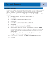
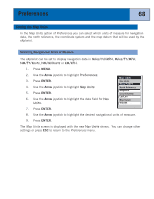
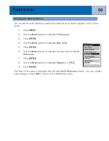
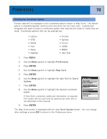
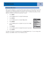
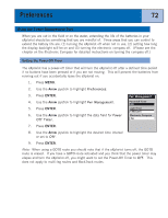
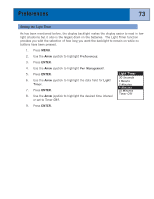
Preferences 68 Setting the Map Units In the Map Units option of Preferences you can select which units of measure for navigation data, the north reference, the coordinate system and the map datum that will be used by the eXplorist. Selecting Navigational Units of Measure The eXplorist can be set to display navigation data in Miles/Yd/MPH, Miles/Ft/MPH, NM/Ft/Knots, NM/M/Knots or KM/KPH. 1. Press MENU. 2. Use the Arrow joystick to highlight Preferences. 3. Press ENTER. 4. Use the Arrow joystick to highlight Map Units. 5. Press ENTER. 6. Use the Arrow joystick to highlight the data field for Nav Units. Map Units Nav Units Miles/Ft/MPH North Reference Magnetic Coord System Lat/Lon Map Datum WGS84 7. Press ENTER. 8. Use the Arrow joystick to highlight the desired navigational units of measure. 9. Press ENTER. The Map Units screen is displayed with the new Nav Units shown. You can change other settings or press ESC to return to the Preferences menu.
-
 1
1 -
2
-
3
-
4
-
5
-
6
-
7
-
8
-
9
-
10
-
11
-
12
-
13
-
14
-
15
-
16
-
17
-
18
-
19
-
20
-
21
-
22
-
23
-
24
-
25
-
26
-
27
-
28
-
29
-
30
-
31
-
32
-
33
-
34
-
35
-
36
-
37
-
38
-
39
-
40
-
41
-
42
-
43
-
44
-
45
-
46
-
47
-
48
-
49
-
50
-
51
-
52
-
53
-
54
-
55
-
56
-
57
-
58
-
59
-
60
-
61
-
62
-
63
-
64
-
65
-
66
-
67
-
68
-
 69
69 -
 70
70 -
 71
71 -
 72
72 -
 73
73 -
 74
74 -
 75
75 -
 76
76 -
 77
77 -
 78
78 -
 79
79 -
80
-
81
-
82
-
83
-
84
-
85
-
86
-
87
-
88
-
89
 |
 |