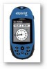
Magellan eXplorist 300 Manual - English - Page 25
Changing the Primary Usage
 |
UPC - 763357109382
View all Magellan eXplorist 300 manuals
Add to My Manuals
Save this manual to your list of manuals |
Page 25 highlights
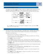
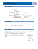
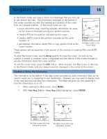
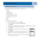
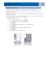
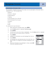
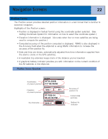
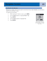
Navigation Screens 19 Changing the Primary Usage The Map screen can be changed to be primarily used on land (default) or marine. When in land usage, land areas are displayed as white areas on the display and water is displayed as dark gray. The opposite is true when the map is set for marine usage. (Water is white and land areas are displayed as dark gray.) This is provided as an option to provide you with the ability to view the text and map details more easily, depending on where you are navigating. To change the primary usage: 1. While viewing the Map screen, press MENU. 2. Use the Arrow joystick to highlight Map Setup. 3. Press ENTER. 4. Use the Arrow joystick to highlight the Primary Usage field. 5. Press ENTER. 6. Use the Arrow joystick to highlight Marine or Land. 7. Press ENTER. 8. Press NAV to return to the Map screen. South Lake Tahoe 50 50 89 3.50mi Heading 030M° Rocky Slo 88 88 Speed 48.0MH The Map screen with the primary usage in Land South Lake Tahoe 50 50 89 3.50mi Heading 030M° Rocky Slo 88 88 Speed 48.0 M H The Map screen with the primary usage in Marine
-
 1
1 -
2
-
3
-
4
-
5
-
6
-
7
-
8
-
9
-
10
-
11
-
12
-
13
-
14
-
15
-
16
-
17
-
18
-
19
-
 20
20 -
 21
21 -
 22
22 -
 23
23 -
 24
24 -
 25
25 -
 26
26 -
 27
27 -
 28
28 -
 29
29 -
 30
30 -
31
-
32
-
33
-
34
-
35
-
36
-
37
-
38
-
39
-
40
-
41
-
42
-
43
-
44
-
45
-
46
-
47
-
48
-
49
-
50
-
51
-
52
-
53
-
54
-
55
-
56
-
57
-
58
-
59
-
60
-
61
-
62
-
63
-
64
-
65
-
66
-
67
-
68
-
69
-
70
-
71
-
72
-
73
-
74
-
75
-
76
-
77
-
78
-
79
-
80
-
81
-
82
-
83
-
84
-
85
-
86
-
87
-
88
-
89
 |
 |
