Magellan eXplorist 300 Manual - English - Page 20
Navigation Screens, Map Screen - accuracy
 |
UPC - 763357109382
View all Magellan eXplorist 300 manuals
Add to My Manuals
Save this manual to your list of manuals |
Page 20 highlights
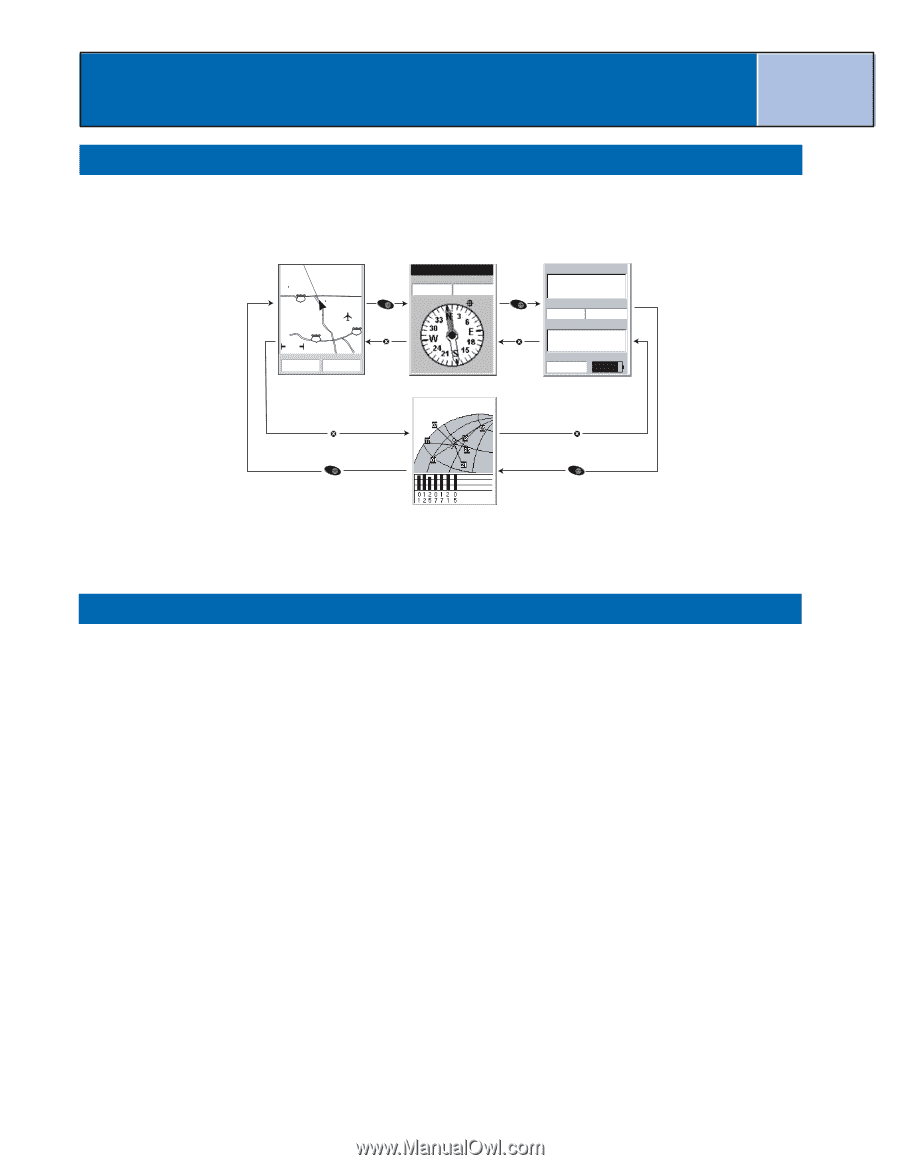
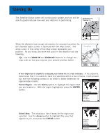
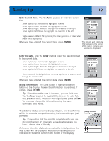
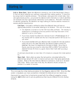
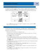
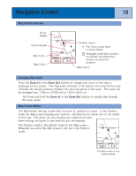
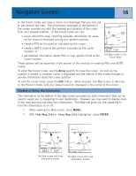
Navigation Screens 14 Accessing the Navigation Screens The eXplorist has three navigation screens, as well as a Satellite Status screen that can be accessed by pressing the NAV button. Each screen provides the same information in a different format, giving you the choice of choosing the screen that best suits your needs. Glendora 210 San Dimas ent vina 10 10 1.60mi Heading Speed 352 o M 4.3 M H NAV ESC To: Canyon Speed Distance 4.3 M H 5.84 M I NAV ESC Location 34°06.556N 117°49.563W Elevation 1292 FT Accuracy 25 FT Date/Time 01 FEB 04 03:30:36 PM Trip Odometer Battery 0000.0 M I 3D Position Fix Tracking 7.... ESC ESC NAV NAV Tip: The ESC button will also set through the navigation screens, just like the NAV button but in the reverse order. Map Screen The first, and most commonly used screen, is the Map screen. The Map screen displays your position, as well as POI's and any background map data for the area displayed. Highlights of the Map screen: • Use the zoom in/out buttons to change the scale. • The arrow cursor in the middle of the display indicates your position and, if moving, points in the direction you are heading. • Press MARK to save your position. • Use the Arrow joystick to move the cursor. The arrow cursor changes to a crosshair cursor, with any available information about the position of the cursor at the bottom of the display. You can also save the position of the crosshair cursor as a POI by pressing the MARK button. • Press ESC when you are done panning with the crosshair cursor to display your present position with the arrow cursor. • Press MENU and select Hide Map Info or Show Map Info to turn the information boxes at the bottom of the screen on or off. • Press MENU and select Customize page to change the information displayed at the bottom of the screen. • Press MENU and select Map Setup to change the orientation of the screen and the primary usage (land or marine).
-
 1
1 -
2
-
3
-
4
-
5
-
6
-
7
-
8
-
9
-
10
-
11
-
12
-
13
-
14
-
 15
15 -
 16
16 -
 17
17 -
 18
18 -
 19
19 -
 20
20 -
 21
21 -
 22
22 -
 23
23 -
 24
24 -
 25
25 -
26
-
27
-
28
-
29
-
30
-
31
-
32
-
33
-
34
-
35
-
36
-
37
-
38
-
39
-
40
-
41
-
42
-
43
-
44
-
45
-
46
-
47
-
48
-
49
-
50
-
51
-
52
-
53
-
54
-
55
-
56
-
57
-
58
-
59
-
60
-
61
-
62
-
63
-
64
-
65
-
66
-
67
-
68
-
69
-
70
-
71
-
72
-
73
-
74
-
75
-
76
-
77
-
78
-
79
-
80
-
81
-
82
-
83
-
84
-
85
-
86
-
87
-
88
-
89
 |
 |