Nikon COOLPIX AW100 Reference Manual - Page 111
Notes on GPS, Pictures with Recorded Position Information, Record GPS data
 |
View all Nikon COOLPIX AW100 manuals
Add to My Manuals
Save this manual to your list of manuals |
Page 111 highlights
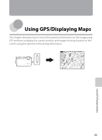
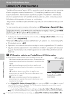
Starting GPS Data Recording B Notes on GPS • When positioning for the first time, when positioning was unable to be performed for about two hours, or after the battery was changed, it takes a few minutes to obtain the position information. • Positions of the GPS satellites change constantly. You may not be able to determine the position or it may take some time depending on your location and the time. To use the GPS feature, use the camera as much as possible in an open-air area. Signal receiving will be smoother if the GPS antenna (A2) is facing the sky. • If the camera needs to be turned off inside an airplane or hospital, set the Record GPS data to Off. • The following locations which block or reflect signals may result in failed or inaccurate positioning. - Inside buildings or at the basement of buildings - Between high-rise buildings - Under overpasses - Inside tunnels - Near high-voltage electrical power lines - Between clusters of trees - Underwater • Using a mobile phone of 1.5 GHz band near this camera may disrupt positioning. • When carrying this camera around while positioning, do not place it in a metal bag. Positioning cannot be performed if the camera is covered in metal materials. • When there is a significant difference in the signals from the GPS satellite, there could be a deviation of up to several hundred meters. • Be aware of your surroundings when positioning. • If Record GPS data is set to On and the camera is turned off, positioning will be done every 30 minutes for up to six hours. If positioning cannot be done, positioning will be done every 15 minutes for up to an hour. Positioning will cancel if positioning cannot be done after three minutes. • The date and time of the camera's internal clock at the time of shooting is recorded at the date and time of recording indicators displayed on the camera during playback. The time obtained by the position information and recorded on images will not be displayed on the camera. • Position information will be recorded on the first frame of pictures shot using continuous shooting mode. • The Geodetic system for this camera's GPS function uses the WGS 84 (World Geodetic System 1984). C Pictures with Recorded Position Information • The z icon is displayed during playback for images which have the position information recorded (A8). • Position information recorded on a picture can be checked on a map with ViewNX2 after transferring the image to a computer (A74). • The actual place of shooting may differ from the GPS information recorded on the image files due to the accuracy of the position information obtained and a difference in the Geodetic system used. 87 Using GPS/Displaying Maps
-
 1
1 -
2
-
3
-
4
-
5
-
6
-
7
-
8
-
9
-
10
-
11
-
12
-
13
-
14
-
15
-
16
-
17
-
18
-
19
-
20
-
21
-
22
-
23
-
24
-
25
-
26
-
27
-
28
-
29
-
30
-
31
-
32
-
33
-
34
-
35
-
36
-
37
-
38
-
39
-
40
-
41
-
42
-
43
-
44
-
45
-
46
-
47
-
48
-
49
-
50
-
51
-
52
-
53
-
54
-
55
-
56
-
57
-
58
-
59
-
60
-
61
-
62
-
63
-
64
-
65
-
66
-
67
-
68
-
69
-
70
-
71
-
72
-
73
-
74
-
75
-
76
-
77
-
78
-
79
-
80
-
81
-
82
-
83
-
84
-
85
-
86
-
87
-
88
-
89
-
90
-
91
-
92
-
93
-
94
-
95
-
96
-
97
-
98
-
99
-
100
-
101
-
102
-
103
-
104
-
105
-
 106
106 -
 107
107 -
 108
108 -
 109
109 -
 110
110 -
 111
111 -
 112
112 -
 113
113 -
 114
114 -
 115
115 -
 116
116 -
117
-
118
-
119
-
120
-
121
-
122
-
123
-
124
-
125
-
126
-
127
-
128
-
129
-
130
-
131
-
132
-
133
-
134
-
135
-
136
-
137
-
138
-
139
-
140
-
141
-
142
-
143
-
144
-
145
-
146
-
147
-
148
-
149
-
150
-
151
-
152
-
153
-
154
-
155
-
156
-
157
-
158
-
159
-
160
-
161
-
162
-
163
-
164
-
165
-
166
-
167
-
168
-
169
-
170
-
171
-
172
-
173
-
174
-
175
-
176
-
177
-
178
-
179
-
180
-
181
-
182
-
183
-
184
-
185
-
186
-
187
-
188
-
189
-
190
-
191
-
192
-
193
-
194
-
195
-
196
-
197
-
198
-
199
-
200
-
201
-
202
-
203
-
204
-
205
-
206
-
207
-
208
-
209
-
210
-
211
-
212
-
213
-
214
-
215
-
216
-
217
-
218
-
219
-
220
-
221
-
222
-
223
-
224
-
225
-
226
-
227
-
228
-
229
-
230
-
231
-
232
-
233
-
234
-
235
-
236
-
237
-
238
-
239
-
240
-
241
-
242
 |
 |