Nikon COOLPIX AW100 Reference Manual - Page 179
Calculate Distance, Note on Distance Calculation - target
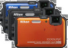 |
View all Nikon COOLPIX AW100 manuals
Add to My Manuals
Save this manual to your list of manuals |
Page 179 highlights
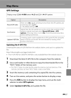
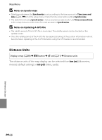
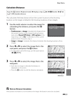
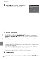
Map Menu Calculate Distance Press the c button (Playback mode) M Display a map (A88) M d button M U tab (A11) M Calculate distance This calculates the linear distance from the current location to the shooting location on the image or between the shooting locations of two images. 1 Use the multi selector to select the target for calculating the distance, and press the k button. Calculate distance Position nowimage Imageimage • Position nowimage: Calculates the distance from the current location to the image shooting location (only when Record GPS data in GPS options of the map menu is set to On). Confirmation of the current position starts. Proceed to step 3. • Imageimage: Calculates the distance between the shooting locations of two images. 2 Press J or K to select the image that is the 500km start point, and press the k button. • To adjust the scale of the map, use the zoom button (f (h)/g (i)). Choose start point 3 Press J or K to select the image that is the end point. • Each time an image is selected, the distance is displayed on the screen. • Press the k button to end the distance calculation. Back 500km Select image Choose end point 100m Back Select image Distance Reference Section B Note on Distance Calculation If the position information is not recorded on the image, the distance cannot be calculated. E59
-
 1
1 -
2
-
3
-
4
-
5
-
6
-
7
-
8
-
9
-
10
-
11
-
12
-
13
-
14
-
15
-
16
-
17
-
18
-
19
-
20
-
21
-
22
-
23
-
24
-
25
-
26
-
27
-
28
-
29
-
30
-
31
-
32
-
33
-
34
-
35
-
36
-
37
-
38
-
39
-
40
-
41
-
42
-
43
-
44
-
45
-
46
-
47
-
48
-
49
-
50
-
51
-
52
-
53
-
54
-
55
-
56
-
57
-
58
-
59
-
60
-
61
-
62
-
63
-
64
-
65
-
66
-
67
-
68
-
69
-
70
-
71
-
72
-
73
-
74
-
75
-
76
-
77
-
78
-
79
-
80
-
81
-
82
-
83
-
84
-
85
-
86
-
87
-
88
-
89
-
90
-
91
-
92
-
93
-
94
-
95
-
96
-
97
-
98
-
99
-
100
-
101
-
102
-
103
-
104
-
105
-
106
-
107
-
108
-
109
-
110
-
111
-
112
-
113
-
114
-
115
-
116
-
117
-
118
-
119
-
120
-
121
-
122
-
123
-
124
-
125
-
126
-
127
-
128
-
129
-
130
-
131
-
132
-
133
-
134
-
135
-
136
-
137
-
138
-
139
-
140
-
141
-
142
-
143
-
144
-
145
-
146
-
147
-
148
-
149
-
150
-
151
-
152
-
153
-
154
-
155
-
156
-
157
-
158
-
159
-
160
-
161
-
162
-
163
-
164
-
165
-
166
-
167
-
168
-
169
-
170
-
171
-
172
-
173
-
 174
174 -
 175
175 -
 176
176 -
 177
177 -
 178
178 -
 179
179 -
 180
180 -
 181
181 -
 182
182 -
 183
183 -
 184
184 -
185
-
186
-
187
-
188
-
189
-
190
-
191
-
192
-
193
-
194
-
195
-
196
-
197
-
198
-
199
-
200
-
201
-
202
-
203
-
204
-
205
-
206
-
207
-
208
-
209
-
210
-
211
-
212
-
213
-
214
-
215
-
216
-
217
-
218
-
219
-
220
-
221
-
222
-
223
-
224
-
225
-
226
-
227
-
228
-
229
-
230
-
231
-
232
-
233
-
234
-
235
-
236
-
237
-
238
-
239
-
240
-
241
-
242
 |
 |
