Nikon COOLPIX AW100 Reference Manual - Page 112
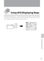
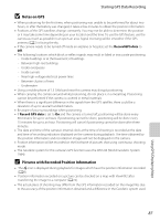
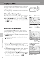
Displaying Maps, When Using Shooting Mode, When Using Playback Mode
 |
View all Nikon COOLPIX AW100 manuals
Add to My Manuals
Save this manual to your list of manuals |
Page 112 highlights
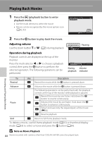
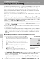
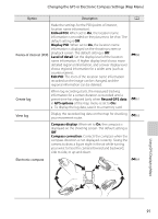
Displaying Maps The current position or image shooting location can be displayed on the screen using the camera's internal map information. To display the map, press the action button in shooting mode or playback mode. When Using Shooting Mode To display the current position on the screen, press the Scale action button in shooting mode when Record GPS 500km data in GPS options of the map menu is set to On. • To adjust the scale of the map, use the zoom button (f (h)/g (i)). GPS reception Using GPS/Displaying Maps When Using Playback Mode If an image displaying z in the full-frame display is selected and the action button is pressed, the image shooting location is displayed on the screen. • To adjust the scale of the map, use the zoom button (f (h)/g (i)). • To move the map display, press the multi selector H, I, J or K. Current position Scale 500km Location name (A86) • When the k button is pressed, another image can be selected. Only images with the recorded position information are displayed in the thumbnail display. • The image shooting location and a rough direction are indicated by C (C indicates north), and the selected image is highlighted in yellow. • Press the multi selector J or K to select the image. • To enlarge the image, press the zoom button g (i). To return to the map display, press f (h). Location name (A86) Image shooting location and direction 500km Thumbnail display 88
-
 1
1 -
2
-
3
-
4
-
5
-
6
-
7
-
8
-
9
-
10
-
11
-
12
-
13
-
14
-
15
-
16
-
17
-
18
-
19
-
20
-
21
-
22
-
23
-
24
-
25
-
26
-
27
-
28
-
29
-
30
-
31
-
32
-
33
-
34
-
35
-
36
-
37
-
38
-
39
-
40
-
41
-
42
-
43
-
44
-
45
-
46
-
47
-
48
-
49
-
50
-
51
-
52
-
53
-
54
-
55
-
56
-
57
-
58
-
59
-
60
-
61
-
62
-
63
-
64
-
65
-
66
-
67
-
68
-
69
-
70
-
71
-
72
-
73
-
74
-
75
-
76
-
77
-
78
-
79
-
80
-
81
-
82
-
83
-
84
-
85
-
86
-
87
-
88
-
89
-
90
-
91
-
92
-
93
-
94
-
95
-
96
-
97
-
98
-
99
-
100
-
101
-
102
-
103
-
104
-
105
-
106
-
 107
107 -
 108
108 -
 109
109 -
 110
110 -
 111
111 -
 112
112 -
 113
113 -
 114
114 -
 115
115 -
 116
116 -
 117
117 -
118
-
119
-
120
-
121
-
122
-
123
-
124
-
125
-
126
-
127
-
128
-
129
-
130
-
131
-
132
-
133
-
134
-
135
-
136
-
137
-
138
-
139
-
140
-
141
-
142
-
143
-
144
-
145
-
146
-
147
-
148
-
149
-
150
-
151
-
152
-
153
-
154
-
155
-
156
-
157
-
158
-
159
-
160
-
161
-
162
-
163
-
164
-
165
-
166
-
167
-
168
-
169
-
170
-
171
-
172
-
173
-
174
-
175
-
176
-
177
-
178
-
179
-
180
-
181
-
182
-
183
-
184
-
185
-
186
-
187
-
188
-
189
-
190
-
191
-
192
-
193
-
194
-
195
-
196
-
197
-
198
-
199
-
200
-
201
-
202
-
203
-
204
-
205
-
206
-
207
-
208
-
209
-
210
-
211
-
212
-
213
-
214
-
215
-
216
-
217
-
218
-
219
-
220
-
221
-
222
-
223
-
224
-
225
-
226
-
227
-
228
-
229
-
230
-
231
-
232
-
233
-
234
-
235
-
236
-
237
-
238
-
239
-
240
-
241
-
242
 |
 |
