Garmin RINO 130 Owner's Manual - Page 116
Data Field Definitions
 |
UPC - 753759031978
View all Garmin RINO 130 manuals
Add to My Manuals
Save this manual to your list of manuals |
Page 116 highlights
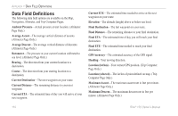
APPENDIX > DATA FIELD DEFINITIONS Data Field Definitions The following data field options are available on the Map, Navigation, Altimeter, and Trip Computer Pages. Ambient Pressure-Actual pressure at unit location. (Altimeter Page Only.) Average Ascent-The average vertical distance of ascents. (Altimeter Page Only.) Average Descent-The average vertical distance of descents. (Altimeter Page Only.) Barometer-The pressure at your current location calibrated to sea level. (Altimeter Page Only.) Bearing-The direction from your current location to a destination. Course-The direction from your starting location to a destination. Current Destination-The next waypoint on your route. Current Distance-The remaining distance to your next waypoint. Current ETA-The estimated time of day you will arrive at your next waypoint. Current ETE-The estimated time needed to arrive at the next waypoint on your route. Elevation-The altitude (height) above or below sea level. Final Destination-The last waypoint on your route. Final Distance-The remaining distance to your final destination. Final ETA-The estimated time of day you will reach your final destination. Final ETE-The estimated time needed to reach your final destination. GPS Accuracy-The estimated accuracy of the GPS signal. Heading-Your moving direction. Location (lat/lon)-Your current GPS position. (Trip Computer Page Only.) Location (selected)-The lat/lon of point defined on map. (Trip Computer Page Only.) Maximum Ascent-The maximum ascent rate in feet per minute. (Altimeter Page Only.) Maximum Descent-The maximum descent rate in feet per minute. (Altimeter Page Only.) 110 Rino® 130 Owner's Manual
-
 1
1 -
2
-
3
-
4
-
5
-
6
-
7
-
8
-
9
-
10
-
11
-
12
-
13
-
14
-
15
-
16
-
17
-
18
-
19
-
20
-
21
-
22
-
23
-
24
-
25
-
26
-
27
-
28
-
29
-
30
-
31
-
32
-
33
-
34
-
35
-
36
-
37
-
38
-
39
-
40
-
41
-
42
-
43
-
44
-
45
-
46
-
47
-
48
-
49
-
50
-
51
-
52
-
53
-
54
-
55
-
56
-
57
-
58
-
59
-
60
-
61
-
62
-
63
-
64
-
65
-
66
-
67
-
68
-
69
-
70
-
71
-
72
-
73
-
74
-
75
-
76
-
77
-
78
-
79
-
80
-
81
-
82
-
83
-
84
-
85
-
86
-
87
-
88
-
89
-
90
-
91
-
92
-
93
-
94
-
95
-
96
-
97
-
98
-
99
-
100
-
101
-
102
-
103
-
104
-
105
-
106
-
107
-
108
-
109
-
110
-
 111
111 -
 112
112 -
 113
113 -
 114
114 -
 115
115 -
 116
116 -
 117
117 -
 118
118 -
 119
119 -
 120
120 -
 121
121 -
122
-
123
-
124
-
125
-
126
-
127
-
128
-
129
-
130
-
131
-
132
 |
 |