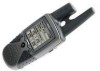
Garmin RINO 130 Owner's Manual - Page 4
Introduction, Getting to Know Your Rino 130, Unit Operation, Using the Rino 130 Radio Features - gps
 |
UPC - 753759031978
View all Garmin RINO 130 manuals
Add to My Manuals
Save this manual to your list of manuals |
Page 4 highlights
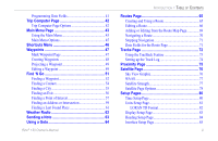
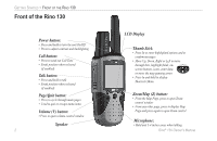
INTRODUCTION > TABLE OF CONTENTS Introduction i Getting to Know Your Rino 130 1 Front of the Rino 130 2 Back of the Rino 130 3 Main Display Pages 4 Operating the Rino 130 5 Status Bar Overview 6 Unit Operation 7 Radio Page 7 Initializing the Rino 130 7 Using My ID and Symbol Fields 8 Setting the Channel and Squelch Code 10 Scanning and Monitoring 12 Radio Page Option Menu 14 Setup Radio 14 Setup Tones 16 Setup Scanlist 16 Use Weather Radio 17 Turn Radio/GPS On/Off 18 Informational Picture 18 GPS Status 18 Radio Transmission Status 18 ii Mark Waypoint's Indicators 19 Using the Rino 130 Radio Features 20 Peer-to-Peer Positioning 20 New Contact Page Overview 20 Sending a Location 23 Map Page 24 Map Page Options 26 Using the Pan Map Option 27 Programming the Data Fields 28 Setting up the Map 29 Measuring Distance 31 Navigation Page 32 Using the Navigation Page 32 Navigation Page Options 34 Using Sight 'N Go 35 Calibrating the Compass 35 Altimeter Page 37 Altimeter Page Options 38 Viewing Pressure/Elevation Plots 39 Adjusting the Zoom Ranges 39 Viewing Points 40 Resetting Data 40 Calibrating the Altimeter 41 Rino® 130 Owner's Manual
-
 1
1 -
 2
2 -
 3
3 -
 4
4 -
 5
5 -
 6
6 -
 7
7 -
 8
8 -
 9
9 -
 10
10 -
11
-
12
-
13
-
14
-
15
-
16
-
17
-
18
-
19
-
20
-
21
-
22
-
23
-
24
-
25
-
26
-
27
-
28
-
29
-
30
-
31
-
32
-
33
-
34
-
35
-
36
-
37
-
38
-
39
-
40
-
41
-
42
-
43
-
44
-
45
-
46
-
47
-
48
-
49
-
50
-
51
-
52
-
53
-
54
-
55
-
56
-
57
-
58
-
59
-
60
-
61
-
62
-
63
-
64
-
65
-
66
-
67
-
68
-
69
-
70
-
71
-
72
-
73
-
74
-
75
-
76
-
77
-
78
-
79
-
80
-
81
-
82
-
83
-
84
-
85
-
86
-
87
-
88
-
89
-
90
-
91
-
92
-
93
-
94
-
95
-
96
-
97
-
98
-
99
-
100
-
101
-
102
-
103
-
104
-
105
-
106
-
107
-
108
-
109
-
110
-
111
-
112
-
113
-
114
-
115
-
116
-
117
-
118
-
119
-
120
-
121
-
122
-
123
-
124
-
125
-
126
-
127
-
128
-
129
-
130
-
131
-
132
 |
 |
