Garmin RINO 130 Owner's Manual - Page 36
General Setup, Tracks Setup, Map Features Setup, Points of Interest, Waypoints, Street Label, and Land - mapsource manual
 |
UPC - 753759031978
View all Garmin RINO 130 manuals
Add to My Manuals
Save this manual to your list of manuals |
Page 36 highlights
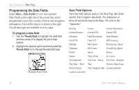
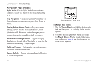
UNIT OPERATION > MAP PAGE General Setup Orientation-Track Up or North Up; fixes the top of the map display to the current track heading or to a north heading. Auto Zoom-On or Off; automatically scales the map to display both your current location and the next point to which you are navigating. Detail-Most, More, Normal, Less, or Least; controls how much map detail you see. This setting only applies to a map feature set to Auto. Those features which have a specified scale or are turned Off are unaffected by this setting. Lock on Road-On or Off; available only if MapSource Data is loaded; when On the triangle icon locks to the road that you are traveling. Display Mode-Land or Water. Tracks Setup Saved Tracks and Track Log-Scale options; Off, Auto, or 20 ft-500 miles, sets the maximum scale at which the feature should appear on the screen. Some types of data display only at certain zoom scales. Goto Line-Bearing or Course. Track Points-Select the number of track points per track. Up to 10,000 active Track Points allowed Map Features Setup Points of Interest, Waypoints, Street Label, and Land Cover-Off, Auto, or 20 ft-500 miles, sets the maximum scale at which that feature should appear on the screen. Some types of data display only at certain zoom scales. 30 Rino® 130 Owner's Manual
-
 1
1 -
2
-
3
-
4
-
5
-
6
-
7
-
8
-
9
-
10
-
11
-
12
-
13
-
14
-
15
-
16
-
17
-
18
-
19
-
20
-
21
-
22
-
23
-
24
-
25
-
26
-
27
-
28
-
29
-
30
-
 31
31 -
 32
32 -
 33
33 -
 34
34 -
 35
35 -
 36
36 -
 37
37 -
 38
38 -
 39
39 -
 40
40 -
 41
41 -
42
-
43
-
44
-
45
-
46
-
47
-
48
-
49
-
50
-
51
-
52
-
53
-
54
-
55
-
56
-
57
-
58
-
59
-
60
-
61
-
62
-
63
-
64
-
65
-
66
-
67
-
68
-
69
-
70
-
71
-
72
-
73
-
74
-
75
-
76
-
77
-
78
-
79
-
80
-
81
-
82
-
83
-
84
-
85
-
86
-
87
-
88
-
89
-
90
-
91
-
92
-
93
-
94
-
95
-
96
-
97
-
98
-
99
-
100
-
101
-
102
-
103
-
104
-
105
-
106
-
107
-
108
-
109
-
110
-
111
-
112
-
113
-
114
-
115
-
116
-
117
-
118
-
119
-
120
-
121
-
122
-
123
-
124
-
125
-
126
-
127
-
128
-
129
-
130
-
131
-
132
 |
 |