Garmin Astro 320 Astro and DC 30 Owner's Manual - Page 35
Viewing Points on the Altimeter Plot, Changing Altimeter Settings, Plot Over Distance
 |
View all Garmin Astro 320 manuals
Add to My Manuals
Save this manual to your list of manuals |
Page 35 highlights
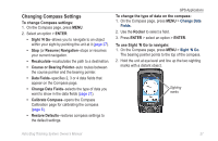
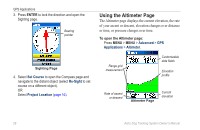
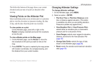
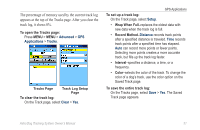
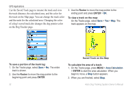
The field at the bottom of the page shows your current elevation and your rate of ascent (or descent) when moving. Viewing Points on the Altimeter Plot Select individual points on an elevation plot or a pressure plot to view the elevation (or pressure) reading, the time of day, and the date when the point was recorded. To view points on a plot: On the Altimeter page, press left or right on the Rocker to display crosshairs and scroll the crosshairs across the plot. To view altitude points on the Map page: 1. On the Altimeter page, use the Rocker to move the red crosshairs to the point you want to view on the map. 2. Press ENTER. The point is marked by the map pointer with location coordinates, the compass bearing, and the distance from your current location. GPS Applications Changing Altimeter Settings To change altimeter settings: 1. On the Altimeter page, press MENU. 2. Select an option > ENTER: • Plot Over Time (or Plot Over Distance)-plots time or distance against elevation. (This option is available only when you are plotting elevation. Pressure is plotted only against time.) • View Elevation Plot (or View Pressure Plot)- selects either an elevation plot or a barometric pressure plot for a set period of time. • Zoom Ranges-selects zoom ranges for elevation, distance, and time for the View Elevation Plot (page 30). • Change Data Fields-selects the type of data shown on the Altimeter page (page 28). • Reset-resets the elevation and maximum elevation data (page 30). Astro Dog Tracking System Owner's Manual 29
-
 1
1 -
2
-
3
-
4
-
5
-
6
-
7
-
8
-
9
-
10
-
11
-
12
-
13
-
14
-
15
-
16
-
17
-
18
-
19
-
20
-
21
-
22
-
23
-
24
-
25
-
26
-
27
-
28
-
29
-
 30
30 -
 31
31 -
 32
32 -
 33
33 -
 34
34 -
 35
35 -
 36
36 -
 37
37 -
 38
38 -
 39
39 -
 40
40 -
41
-
42
-
43
-
44
-
45
-
46
-
47
-
48
-
49
-
50
-
51
-
52
-
53
-
54
-
55
-
56
-
57
-
58
-
59
-
60
-
61
-
62
-
63
-
64
-
65
-
66
-
67
-
68
-
69
-
70
-
71
-
72
-
73
-
74
-
75
-
76
 |
 |