Garmin Astro 320 Astro and DC 30 Owner's Manual - Page 36
Using Tracks, Restore Defaults
 |
View all Garmin Astro 320 manuals
Add to My Manuals
Save this manual to your list of manuals |
Page 36 highlights
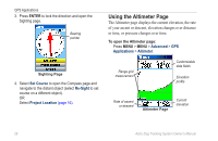
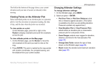
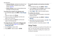
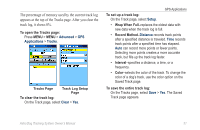
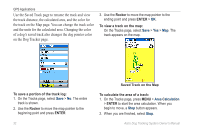
GPS Applications • Calibrate Altimeter-calibrates the altimeter if you know the elevation or pressure at your current location (page 30). • Restore Defaults-clears recorded altimeter data and begins recording new data. To set the zoom ranges for the altimeter plot: 1. On the Altimeter page, press MENU > Zoom Ranges. OR Press up or down on the Rocker. 2. Press up or down on the Rocker to set the zoom range on the vertical axis. 3. Press left or right on the Rocker to set the zoom range on the horizontal axis. To change the type of data on the altimeter page: 1. On the Altimeter page (page 28), press MENU > Change Data Fields. 2. Use the Rocker to select a field. 3. Press ENTER > select an option > ENTER. To reset the elevation and maximum elevation fields: 1. On the Altimeter page, press MENU > Reset.... 2. Use the Rocker and press ENTER to place a check mark next to the items you want to reset. 3. Select Apply > OK to reset the selected options. To calibrate the altimeter: 1. Go to a location where the elevation or barometric pressure is known 2. On the Altimeter page, press MENU > Calibrate Altimeter. 3. Select Yes if you know the elevation, select No > Yes if you know the barometric pressure. 4. Enter the elevation or barometric pressure > OK. Using Tracks A track is a recording of your path and of the path of your dogs. The track log contains information about points along the recorded path, including time, location, and elevation for each point. 30 Astro Dog Tracking System Owner's Manual
-
 1
1 -
2
-
3
-
4
-
5
-
6
-
7
-
8
-
9
-
10
-
11
-
12
-
13
-
14
-
15
-
16
-
17
-
18
-
19
-
20
-
21
-
22
-
23
-
24
-
25
-
26
-
27
-
28
-
29
-
30
-
 31
31 -
 32
32 -
 33
33 -
 34
34 -
 35
35 -
 36
36 -
 37
37 -
 38
38 -
 39
39 -
 40
40 -
 41
41 -
42
-
43
-
44
-
45
-
46
-
47
-
48
-
49
-
50
-
51
-
52
-
53
-
54
-
55
-
56
-
57
-
58
-
59
-
60
-
61
-
62
-
63
-
64
-
65
-
66
-
67
-
68
-
69
-
70
-
71
-
72
-
73
-
74
-
75
-
76
 |
 |