Garmin G3X Pilots Guide - Page 223
TRAFFIC GROUND TRACK, DISPLAYING TRAFFIC DATA, Displaying Traffic information using the map pointer
 |
View all Garmin G3X manuals
Add to My Manuals
Save this manual to your list of manuals |
Page 223 highlights
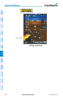
System Overview Flight Instruments EIS CNS Interface GPS Navigation Hazard Avoidance TRAFFIC GROUND TRACK Traffic ground track is indicated on the G3X screen by a "target track vector", a short line shown in 45-degree increments, extending in the direction of target movement. DISPLAYING TRAFFIC DATA Traffic is displayed by default on the Map Page and the Traffic Warning Window. Traffic information is also displayed on the PFD when Synthetic Vision is enabled. See the 'Additional Features' Section for more information. Displaying Traffic information using the map pointer: 1) With traffic displayed on the Map Page, press the FMS Joystick. The Map Pointer is activated. 2) Move the FMS Joystick to highlight the desired traffic. Traffic Ground Track Traffic Range and Altitude Separation using Map Pointer Traffic Warning Window Traffic (Map Page) Enabling/disabling traffic data on the Map Page: 1) From the Map Page, press the MENU Key. 2) Turn or move the FMS Joystick to highlight 'Set Up Map', and press the ENT Key. 3) If necessary, turn the FMS Joystick to highlight the 'Map' Category from the horizontal list. 4) Move the FMS Joystick to highlight the 'Traffic Data' field. 5) Turn the FMS Joystick to select 'ON' or 'OFF' from the menu, and press the ENT Key. Flight Planning Hazard Avoidance Additional Features Integrated Autopilot Annun/Alerts Appendix Index 190-01115-00 Rev. F Garmin G3X Pilot's Guide 205
-
 1
1 -
2
-
3
-
4
-
5
-
6
-
7
-
8
-
9
-
10
-
11
-
12
-
13
-
14
-
15
-
16
-
17
-
18
-
19
-
20
-
21
-
22
-
23
-
24
-
25
-
26
-
27
-
28
-
29
-
30
-
31
-
32
-
33
-
34
-
35
-
36
-
37
-
38
-
39
-
40
-
41
-
42
-
43
-
44
-
45
-
46
-
47
-
48
-
49
-
50
-
51
-
52
-
53
-
54
-
55
-
56
-
57
-
58
-
59
-
60
-
61
-
62
-
63
-
64
-
65
-
66
-
67
-
68
-
69
-
70
-
71
-
72
-
73
-
74
-
75
-
76
-
77
-
78
-
79
-
80
-
81
-
82
-
83
-
84
-
85
-
86
-
87
-
88
-
89
-
90
-
91
-
92
-
93
-
94
-
95
-
96
-
97
-
98
-
99
-
100
-
101
-
102
-
103
-
104
-
105
-
106
-
107
-
108
-
109
-
110
-
111
-
112
-
113
-
114
-
115
-
116
-
117
-
118
-
119
-
120
-
121
-
122
-
123
-
124
-
125
-
126
-
127
-
128
-
129
-
130
-
131
-
132
-
133
-
134
-
135
-
136
-
137
-
138
-
139
-
140
-
141
-
142
-
143
-
144
-
145
-
146
-
147
-
148
-
149
-
150
-
151
-
152
-
153
-
154
-
155
-
156
-
157
-
158
-
159
-
160
-
161
-
162
-
163
-
164
-
165
-
166
-
167
-
168
-
169
-
170
-
171
-
172
-
173
-
174
-
175
-
176
-
177
-
178
-
179
-
180
-
181
-
182
-
183
-
184
-
185
-
186
-
187
-
188
-
189
-
190
-
191
-
192
-
193
-
194
-
195
-
196
-
197
-
198
-
199
-
200
-
201
-
202
-
203
-
204
-
205
-
206
-
207
-
208
-
209
-
210
-
211
-
212
-
213
-
214
-
215
-
216
-
217
-
 218
218 -
 219
219 -
 220
220 -
 221
221 -
 222
222 -
 223
223 -
 224
224 -
 225
225 -
 226
226 -
 227
227 -
 228
228 -
229
-
230
-
231
-
232
-
233
-
234
-
235
-
236
-
237
-
238
-
239
-
240
-
241
-
242
-
243
-
244
-
245
-
246
-
247
-
248
-
249
-
250
-
251
-
252
-
253
-
254
-
255
-
256
-
257
-
258
-
259
-
260
-
261
-
262
-
263
-
264
-
265
-
266
-
267
-
268
-
269
-
270
-
271
-
272
-
273
-
274
-
275
-
276
-
277
-
278
-
279
-
280
-
281
-
282
-
283
-
284
-
285
-
286
-
287
-
288
-
289
-
290
-
291
-
292
-
293
-
294
-
295
-
296
-
297
-
298
-
299
-
300
-
301
-
302
-
303
-
304
-
305
-
306
-
307
-
308
-
309
-
310
-
311
-
312
-
313
-
314
-
315
-
316
-
317
-
318
-
319
-
320
-
321
-
322
-
323
-
324
-
325
-
326
-
327
-
328
-
329
-
330
-
331
-
332
-
333
-
334
-
335
-
336
-
337
-
338
-
339
-
340
-
341
-
342
-
343
-
344
-
345
-
346
-
347
-
348
-
349
-
350
-
351
-
352
-
353
-
354
-
355
-
356
-
357
-
358
-
359
-
360
-
361
-
362
-
363
-
364
-
365
-
366
-
367
-
368
-
369
-
370
-
371
-
372
 |
 |
