Garmin GPS 18 nRoute Printable Help Contents - Page 14
Checking Satellite Status, Poor GPS Coverage, 2D Navigation, 2D Differential - gps18x manual
 |
UPC - 753759042660
View all Garmin GPS 18 manuals
Add to My Manuals
Save this manual to your list of manuals |
Page 14 highlights
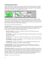
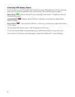
Checking Satellite Status After connecting your GPS receiver, you can check the Satellites Tab to verify that your GPS is acquiring satellites. The Satellites Tab appears along the bottom of the screen. It shows the satellites your GPS has acquired, their signal strength, the accuracy of navigation, and your current position. You can activate the Satellites Tab by clicking on it or pressing F11 on your keyboard. nRoute can utilize WAAS (Wide Area Augmentation System), provided your GPS is enabled to receive WAAS satellites. WAAS technology is a system of satellites and ground stations that provide GPS signal corrections, giving you better position accuracy. WAAS is most effective in the U.S.A. If you are located in another part of the world, it is recommended that you turn off WAAS for the most accurate location fix. See What is WAAS? on the Garmin Web site for more information. The Satellites Tab contains the following features: Connection Status-the Connection Status field contains information about the type of signal that your GPS is receiving. If your GPS is not connected, the message "Attempting Connection to Unit" appears. When your GPS is connected, the message "Searching for Satellites" appears. Based upon the satellites your GPS receives, one of the following connection status messages appears: Poor GPS Coverage-your GPS is receiving fewer than three GPS satellites and cannot determine your location accurately. 2D Navigation-your GPS is receiving three GPS satellites and has determined your 2D location (latitude and longitude). 2D Differential-your GPS is receiving three GPS satellites, one of which is a WAAS satellite. 3D Navigation-your GPS is receiving four or more GPS satellites and has determined your 3D location (latitude, longitude, and elevation). 3D Differential-your GPS is receiving four or more satellites and has determined your 3D location (latitude, longitude, and elevation) with WAAS enabled. GPS Signal Strength-this graph indicates the strength of the GPS signal being received from each corresponding numbered satellite. Satellites numbered 32 and below are GPS satellites, while satellites numbered greater than 32 are WAAS satellites. GPS Satellite Location View-these large white circles show the positions of satellites in the sky overhead, with the center of the circles representing your current position. The outer circle indicates the horizon; the inner circle indicates a position 45° from the horizon. The small, numbered circles indicate the satellites and the numbers assigned to them. These small circles turn green to indicate that a satellite is being used to determine your location. Yellow indicates a satellite has been located but is still initializing, and is not yet being used to determine your location. White indicates that no signals are being received. Accuracy-the accuracy of the GPS system. 12
-
 1
1 -
2
-
3
-
4
-
5
-
6
-
7
-
8
-
 9
9 -
 10
10 -
 11
11 -
 12
12 -
 13
13 -
 14
14 -
 15
15 -
 16
16 -
 17
17 -
 18
18 -
 19
19 -
20
-
21
-
22
-
23
-
24
-
25
-
26
-
27
-
28
-
29
-
30
-
31
-
32
-
33
-
34
-
35
-
36
-
37
-
38
-
39
-
40
-
41
-
42
-
43
-
44
-
45
-
46
-
47
-
48
-
49
-
50
-
51
-
52
-
53
-
54
-
55
-
56
-
57
-
58
-
59
-
60
-
61
-
62
-
63
-
64
-
65
-
66
-
67
-
68
-
69
-
70
-
71
-
72
-
73
-
74
-
75
-
76
-
77
-
78
-
79
-
80
-
81
-
82
-
83
-
84
-
85
-
86
-
87
-
88
-
89
-
90
-
91
-
92
-
93
-
94
-
95
-
96
-
97
-
98
-
99
-
100
-
101
-
102
-
103
-
104
-
105
-
106
-
107
-
108
-
109
-
110
-
111
-
112
-
113
-
114
-
115
-
116
-
117
-
118
-
119
-
120
-
121
-
122
-
123
-
124
-
125
-
126
-
127
-
128
-
129
-
130
 |
 |
