Pioneer AVIC N2 Owner's Manual - Page 33
City Map, Display items
 |
UPC - 012562735191
View all Pioneer AVIC N2 manuals
Add to My Manuals
Save this manual to your list of manuals |
Page 33 highlights
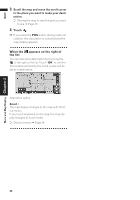
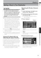
NAVI Chapter 2 Menu and Map Display ❒ When set to Driver's View and Vehicle Dynamics, the system cannot be changed to an enlarged intersection map. Display during freeway driving In select locations of the freeway, lane information is available, indicating the recommended lane to be in to easily maneuver the next guidance. (20) When driving on the freeway, freeway exit num- bers and freeway signs may be displayed when in the vicinity of interchanges and exits. (21) (22) City Map In certain metropolitan city areas, a more detailed "City Map" is available at the 0.05 mi (50m) map scale or lower. (1) (11) (8) (2) (7) (4) (12) (9) (5) (3) (6) ❒ Detailed city map is not displayed during the memory navi mode. ❒ Except when on a freeway, if you are driving by an area where a City Map is available, at the 0.1 mi (100 m) map scale, a message appears informing you that have entered a city map area. Display items Guidance point* The next guidance point (next turning point, etc.) is shown by a yellow flag. Destination* The checker-flag indicates your destination. (1) Name of the next street to be used* (2) Distance to the guidance point* Touch to access the next information. (3) Current location The current location of your vehicle. The tip of the triangular mark indicates your heading and the display moves automatically as you drive. (4) Distance to the destination (or distance to way point)* If way points are set, the display changes with each touch. When two or more way points are set, the distance to the destination and the distance to the next way point are switched. (5) Name of the street your vehicle is traveling along (or City Name, etc.) (6) Compass The red arrow indicates north. If the scale is less than 25 mi (50 km), touching the map changes the direction it is displayed in (north up/heading up). When the scale of the map is not less than 25 mi (50 km), it is fixed to "north up". Heading up The map display always shows the vehicle's direction as proceeding toward the top of the screen. North up The map display always has north at the top of the screen. (7) Zoom in/Zoom out Touch to change the map's scale. ➲ Changing the map's scale ➞ Page 32 (8) Map scale The scale of the map is indicated by distance. Except for on the Vehicle Dynamics Display, the scale of the map is displayed at the top right of the screen. ➲ Changing the map's scale ➞ Page 32 31
-
 1
1 -
2
-
3
-
4
-
5
-
6
-
7
-
8
-
9
-
10
-
11
-
12
-
13
-
14
-
15
-
16
-
17
-
18
-
19
-
20
-
21
-
22
-
23
-
24
-
25
-
26
-
27
-
 28
28 -
 29
29 -
 30
30 -
 31
31 -
 32
32 -
 33
33 -
 34
34 -
 35
35 -
 36
36 -
 37
37 -
 38
38 -
39
-
40
-
41
-
42
-
43
-
44
-
45
-
46
-
47
-
48
-
49
-
50
-
51
-
52
-
53
-
54
-
55
-
56
-
57
-
58
-
59
-
60
-
61
-
62
-
63
-
64
-
65
-
66
-
67
-
68
-
69
-
70
-
71
-
72
-
73
-
74
-
75
-
76
-
77
-
78
-
79
-
80
-
81
-
82
-
83
-
84
-
85
-
86
-
87
-
88
-
89
-
90
-
91
-
92
-
93
-
94
-
95
-
96
-
97
-
98
-
99
-
100
-
101
-
102
-
103
-
104
-
105
-
106
-
107
-
108
-
109
-
110
-
111
-
112
-
113
-
114
-
115
-
116
-
117
-
118
-
119
-
120
-
121
-
122
-
123
-
124
-
125
-
126
-
127
-
128
-
129
-
130
-
131
-
132
-
133
-
134
-
135
-
136
-
137
-
138
-
139
 |
 |
