Garmin GPSMAP 67i Owners Manual - Page 18
Opening the Main Menu, Map, Navigating with the Map, Measuring Distance on the Map, Map Settings
 |
View all Garmin GPSMAP 67i manuals
Add to My Manuals
Save this manual to your list of manuals |
Page 18 highlights
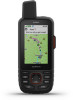
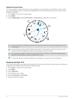
Opening the Main Menu The main menu gives you access to tools and setup screens for waypoints, activities, routes, and more (Main Menu Tools, page 32, Setup Menu, page 43). From any page, press MENU twice. Map represents your location on the map. As you travel, moves and displays your path. Depending on your zoom level, waypoint names and symbols may appear on the map. You can zoom in on the map to see more detail. When you are navigating to a destination, your route is marked with a colored line on the map. Navigating with the Map 1 Begin navigating to a destination (Navigating to a Destination, page 18). 2 Press PAGE to scroll to the map page. A blue triangle represents your location on the map. As you travel, the blue triangle moves and displays your path. 3 Complete one or more actions: • To view different areas of the map, press , , , or . • To zoom in and out of the map, press and . • To view more information about a waypoint on the map (represented by an icon) or other location, move the map cursor to the location, and press ENTER. Measuring Distance on the Map You can measure the distance between multiple locations. 1 Press PAGE to scroll to the map page. 2 Press MENU. 3 Select Measure Distance. 4 Press , , , and to move the map cursor to a location. The measured distance appears. 5 Press ENTER to select additional locations on the map. Map Page Settings Press PAGE to scroll to the map page, and press MENU. Show Dashboard: Allows you to show or hide the dashboard after setting one to display on the map (Map Settings, page 13). Stop Navigation: Stops navigating the current route. Map Setup: Allows you to customize additional map settings (Map Settings, page 13). Measure Distance: Allows you to measure the distance between multiple locations (Measuring Distance on the Map, page 12). Change Data Fields: Allows you to customize the data fields on the dashboard. Restore Defaults: Restores the map to factory default settings. 12 Using the Main Pages
-
 1
1 -
2
-
3
-
4
-
5
-
6
-
7
-
8
-
9
-
10
-
11
-
12
-
 13
13 -
 14
14 -
 15
15 -
 16
16 -
 17
17 -
 18
18 -
 19
19 -
 20
20 -
 21
21 -
 22
22 -
 23
23 -
24
-
25
-
26
-
27
-
28
-
29
-
30
-
31
-
32
-
33
-
34
-
35
-
36
-
37
-
38
-
39
-
40
-
41
-
42
-
43
-
44
-
45
-
46
-
47
-
48
-
49
-
50
-
51
-
52
-
53
-
54
-
55
-
56
-
57
-
58
-
59
-
60
-
61
-
62
-
63
-
64
-
65
-
66
 |
 |
