Lowrance HDS-7 Carbon Operators Manual EN - Page 29
Measuring distance, Creating a Man Overboard waypoint
 |
View all Lowrance HDS-7 Carbon manuals
Add to My Manuals
Save this manual to your list of manuals |
Page 29 highlights
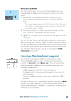
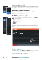
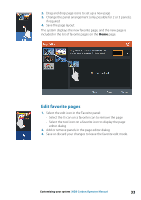
Measuring distance The cursor can be used to measure the distance between your vessel and a selected position, or between 2 points on the chart panel. 1. Position the cursor on the point from where you want to measure the distance. Start the measure function from the menu - The measuring icons appear with a line drawn from the vessel center to the cursor position, and the distance is listed in the cursor information window. 2. You can reposition the measuring points by dragging either icon as long as the measuring function is active Ú Note: The bearing is always measured from the grey icon to the blue icon. You can also start the measuring function without an active cursor. Both measuring icons are then initially located at the vessel position. The grey icon follows the vessel as the vessel moves, while the blue icon remains at the position given when you activated the function. You terminate the measuring function by selecting the Finish measuring menu option. Creating a Man Overboard waypoint If an emergency situation should occur, you can save a Man Overboard (MOB) waypoint at the vessel's current position by pressing the Zoom In (+) and Zoom out (-) keys simultaneously. When you activate the MOB function the following actions are automatically performed: • a MOB waypoint is created at the vessel's position • the display switches to a zoomed chart panel, centered on the vessel's position • the system displays navigation information back to the MOB waypoint Multiple MOB waypoints are saved by repeatedly pressing the MOB buttons. The vessel continues to show navigation information to the initial MOB waypoint. Navigation to subsequent MOB waypoints needs to be done manually. Basic operation | HDS Carbon Operator Manual 29
-
 1
1 -
2
-
3
-
4
-
5
-
6
-
7
-
8
-
9
-
10
-
11
-
12
-
13
-
14
-
15
-
16
-
17
-
18
-
19
-
20
-
21
-
22
-
23
-
 24
24 -
 25
25 -
 26
26 -
 27
27 -
 28
28 -
 29
29 -
 30
30 -
 31
31 -
 32
32 -
 33
33 -
 34
34 -
35
-
36
-
37
-
38
-
39
-
40
-
41
-
42
-
43
-
44
-
45
-
46
-
47
-
48
-
49
-
50
-
51
-
52
-
53
-
54
-
55
-
56
-
57
-
58
-
59
-
60
-
61
-
62
-
63
-
64
-
65
-
66
-
67
-
68
-
69
-
70
-
71
-
72
-
73
-
74
-
75
-
76
-
77
-
78
-
79
-
80
-
81
-
82
-
83
-
84
-
85
-
86
-
87
-
88
-
89
-
90
-
91
-
92
-
93
-
94
-
95
-
96
-
97
-
98
-
99
-
100
-
101
-
102
-
103
-
104
-
105
-
106
-
107
-
108
-
109
-
110
-
111
-
112
-
113
-
114
-
115
-
116
-
117
-
118
-
119
-
120
-
121
-
122
-
123
-
124
-
125
-
126
-
127
-
128
-
129
-
130
-
131
-
132
-
133
-
134
-
135
-
136
-
137
-
138
-
139
-
140
-
141
-
142
-
143
-
144
-
145
-
146
-
147
-
148
-
149
-
150
-
151
-
152
-
153
-
154
-
155
-
156
-
157
-
158
-
159
-
160
-
161
-
162
-
163
-
164
-
165
-
166
-
167
-
168
-
169
-
170
-
171
-
172
-
173
-
174
-
175
-
176
-
177
-
178
-
179
-
180
-
181
-
182
-
183
-
184
-
185
-
186
-
187
-
188
-
189
-
190
-
191
-
192
-
193
-
194
-
195
-
196
-
197
-
198
 |
 |
