Lowrance HDS-7 Carbon Operators Manual EN - Page 36
Selecting chart type, Panning the chart, Vessel symbol, Chart scale
 |
View all Lowrance HDS-7 Carbon manuals
Add to My Manuals
Save this manual to your list of manuals |
Page 36 highlights
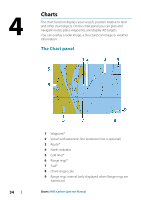
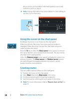
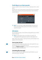
Selecting chart type You specify the chart type in the Chart panel by selecting one of the available chart types in the chart source menu option. If you have a multiple Chart panel, the chart type is set individually for each chart panel. Activate one of the chart panels, and then select one of the available chart types in the chart source menu option. Repeat the process for the second chart panel, and select an alternative chart type for this panel. Panning the chart You can move the chart in any direction by: • Touch operation: dragging your finger on the screen • Key operation: using the Cursor keys to move the cursor to the edge of the chart panel in the desired direction Select the Clear cursor menu option or press the X key to remove the cursor and cursor window from the panel. This also centers the chart to the vessel position. Vessel symbol When the system has a valid GPS position lock, the vessel symbol indicates vessel position. If no GPS position is available, the vessel symbol includes a question mark. Ú Note: Without a heading sensor on the network, the vessel icon orientates itself using COG (Course over Ground). Chart scale You zoom in and out on the chart by using the zoom (+ or -) buttons, the + or - keys, or two fingers to pinch (zoom out) and spread (zoom in). Chart range scale and range rings interval (when turned on) are shown in the lower right corner of the chart panel. 36 Charts | HDS Carbon Operator Manual
-
 1
1 -
2
-
3
-
4
-
5
-
6
-
7
-
8
-
9
-
10
-
11
-
12
-
13
-
14
-
15
-
16
-
17
-
18
-
19
-
20
-
21
-
22
-
23
-
24
-
25
-
26
-
27
-
28
-
29
-
30
-
 31
31 -
 32
32 -
 33
33 -
 34
34 -
 35
35 -
 36
36 -
 37
37 -
 38
38 -
 39
39 -
 40
40 -
 41
41 -
42
-
43
-
44
-
45
-
46
-
47
-
48
-
49
-
50
-
51
-
52
-
53
-
54
-
55
-
56
-
57
-
58
-
59
-
60
-
61
-
62
-
63
-
64
-
65
-
66
-
67
-
68
-
69
-
70
-
71
-
72
-
73
-
74
-
75
-
76
-
77
-
78
-
79
-
80
-
81
-
82
-
83
-
84
-
85
-
86
-
87
-
88
-
89
-
90
-
91
-
92
-
93
-
94
-
95
-
96
-
97
-
98
-
99
-
100
-
101
-
102
-
103
-
104
-
105
-
106
-
107
-
108
-
109
-
110
-
111
-
112
-
113
-
114
-
115
-
116
-
117
-
118
-
119
-
120
-
121
-
122
-
123
-
124
-
125
-
126
-
127
-
128
-
129
-
130
-
131
-
132
-
133
-
134
-
135
-
136
-
137
-
138
-
139
-
140
-
141
-
142
-
143
-
144
-
145
-
146
-
147
-
148
-
149
-
150
-
151
-
152
-
153
-
154
-
155
-
156
-
157
-
158
-
159
-
160
-
161
-
162
-
163
-
164
-
165
-
166
-
167
-
168
-
169
-
170
-
171
-
172
-
173
-
174
-
175
-
176
-
177
-
178
-
179
-
180
-
181
-
182
-
183
-
184
-
185
-
186
-
187
-
188
-
189
-
190
-
191
-
192
-
193
-
194
-
195
-
196
-
197
-
198
 |
 |
