Magellan Triton 400 Manual - English - Page 26
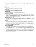
Elevation, Current Speed, Average Speed, Maximum Speed, Distance Made Good, Estimated Time of Arrival
 |
UPC - 763357117769
View all Magellan Triton 400 manuals
Add to My Manuals
Save this manual to your list of manuals |
Page 26 highlights
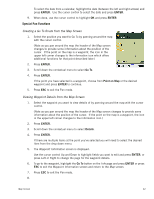
Cross Track Error (XTE) Cross Track Error measures how far the user is off the trail or route. If no Go To or Route is set, this will appear blank or dashes. Elevation Elevation measures the height above or below Sea Level which is 0. Current Speed Current Speed measures how fast the user is travelling. Average Speed Average Speed calculates the average speed of the user. Maximum Speed Maximum Speed records the highest speed achieved by the user. Distance Made Good (DMG) Distance Made Good measures (in distance) the progress the user has made to a final destination point. This may be a negative distance if the user moves away from the target point. If no Go To or Route is set, this will appear blank or dashes. Estimated Time of Arrival (ETA) Estimated Time of Arrival displays the time of day the user should arrive at a destination. If no Go To or Route is set, this will appear blank or dashes. Accuracy Accuracy calculates the margin of error the user can expect based on their satellite reception. The smaller the number is, the better the accuracy. Normally the accuracy is around 10-30 ft (310 m). Things that interfere with satellite reception may decrease the accuracy (increase the number) such as heavy canopies from trees, tunnels, tall buildings, canyons, broadcast satellites, and other GPS receivers too close in proximity. Velocity Made Good (VMG) Velocity Made Good calculates how fast the user is closing their distance to a destination point, not how fast the user is moving. If the user is traveling directly towards the destination point the number should match the Current Speed. If the user is travelling off the direct course to a final destination point, the number should reflect slower than the Current Speed because less actual progress is being made. If the user is moving away from the destination point, the numbers should be negative. If the user is standing still or moving around a consistent radius of the destination point, the number should be zero. Navigation Screens 18
-
 1
1 -
2
-
3
-
4
-
5
-
6
-
7
-
8
-
9
-
10
-
11
-
12
-
13
-
14
-
15
-
16
-
17
-
18
-
19
-
20
-
 21
21 -
 22
22 -
 23
23 -
 24
24 -
 25
25 -
 26
26 -
 27
27 -
 28
28 -
 29
29 -
 30
30 -
 31
31 -
32
-
33
-
34
-
35
-
36
-
37
-
38
-
39
-
40
-
41
-
42
-
43
-
44
-
45
-
46
-
47
-
48
-
49
-
50
-
51
-
52
-
53
-
54
-
55
-
56
-
57
-
58
-
59
-
60
-
61
-
62
-
63
-
64
-
65
 |
 |