Magellan Triton 400 Manual - English - Page 9
Overview, Features of the Magellan Triton - adventure pack
 |
UPC - 763357117769
View all Magellan Triton 400 manuals
Add to My Manuals
Save this manual to your list of manuals |
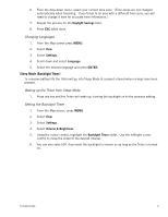
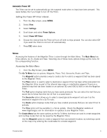
Page 9 highlights
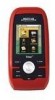
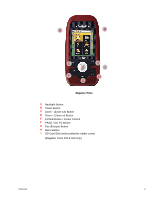
Overview Thank you for your purchase of the Magellan Triton GPS receiver. The Magellan Triton was designed for the outdoor enthusiast with all the features needed to make your outdoor adventures safe and enjoyable. Be sure to register your Magellan Triton at www.magellangps.com to be kept informed of possible software updates and new features as they become available. Also visit the Magellan Triton support page at www.magellangps.com/support/ and select your Magellan Triton model for additional information and tips on the use of your Triton. Features of the Magellan Triton Ease-of-use - Simple menus and an intuitive interface makes using the Magellan Triton easy for first time GPS receiver users while still keeping all the functions experienced users expect to see. Routes and tracks - Create a single leg Go To route, a route with multiple destinations or just use the backtrack function to follow your footsteps back to your point of origin. 3-meter accuracy - The SiRFstarIII™ GPS chipset and an integrated multidirectional antenna offer superior GPS accuracy. The Magellan Triton is also WAAS and EGNOS-capable, taking advantage of the Wide Area Augmentation System for improved accuracy. 3-axis electronic compass (Triton 500 only) - Get accurate compass readings while standing still, even without a GPS fix, and no matter how you hold the receiver. (GPS receivers without an electronic compass require that you are moving before the compass shows your correct heading.) Barometer (Triton 500 only) - Sensitive barometric pressure readings offer advanced notice of changing weather conditions. Built-in map - A built-in base map of the continental United States and Canada display major highways, city centers, bodies of water and much more. Magellan Triton's purchased in Europe may have local area base maps preloaded. Ability to add detailed maps - Access optional detail maps for marine cartography, topographic maps, as well as feature-packed National Geographic maps from an SD card that can be installed in the Magellan Triton or, for the Magellan Triton 300, loaded onto the internal memory. SD-card expansion - (Triton 400 & 500 only) Use an optional SD memory card to upload detailed maps and store media. Overview 1
-
 1
1 -
2
-
3
-
 4
4 -
 5
5 -
 6
6 -
 7
7 -
 8
8 -
 9
9 -
 10
10 -
 11
11 -
 12
12 -
 13
13 -
 14
14 -
15
-
16
-
17
-
18
-
19
-
20
-
21
-
22
-
23
-
24
-
25
-
26
-
27
-
28
-
29
-
30
-
31
-
32
-
33
-
34
-
35
-
36
-
37
-
38
-
39
-
40
-
41
-
42
-
43
-
44
-
45
-
46
-
47
-
48
-
49
-
50
-
51
-
52
-
53
-
54
-
55
-
56
-
57
-
58
-
59
-
60
-
61
-
62
-
63
-
64
-
65
 |
 |