Nikon COOLPIX S9500 Reference Manual - Page 112
CGPS Reception Indicator and Point of Interest POI Information CPictures with Recorded Position Information
 |
View all Nikon COOLPIX S9500 manuals
Add to My Manuals
Save this manual to your list of manuals |
Page 112 highlights
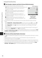
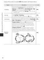
Using GPS/Electronic Compass (COOLPIX S9500 only) Starting GPS Data Recording C GPS Reception Indicator and Point of Interest (POI) Information • GPS reception can be checked on the shooting screen. - n: Signals are being received from four or more satellites and positioning is being performed. Position information is recorded on the image. GPS reception - o: Signals are being received from three satellites and positioning is being performed. Position information is recorded on the image. - z: Signals are being received from the satellites, but positioning is not possible. The position information is not recorded on the image. - y: Signals cannot be received from the satellites, and positioning is not possible. The position information is not recorded on the image. 29m 0s 970 Location name information (POI information) • POI information is location name information for the nearest landmarks (facilities) and other details. - When Display POI in Points of interest (POI) of the GPS options menu (A91) is set to On, the nearest location name information for the current location is displayed during shooting. - When Embed POI is set to On, location name information can be recorded on the image during shooting. - If the location name information is recorded on the image during shooting, this information is displayed when Display POI is set to On during playback. • "----" may be displayed for the location name information depending on the setting level in Level of detail of Points of interest (POI). Also, certain landmark names may not be registered, or the landmark name may be different. C Pictures with Recorded Position Information • The z icon is displayed during playback for images which have the position information recorded (A10). • Position information recorded on a picture can be checked on a map with ViewNX 2 after transferring the image to a computer (A78). • The actual place of shooting may differ from the GPS information recorded on the image files due to the accuracy of the position information obtained and a difference in the geodetic system used. • The position information and POI information recorded on pictures can be erased using Erase GPS data in GPS options (A91). The erased information cannot be recovered. 90
-
 1
1 -
2
-
3
-
4
-
5
-
6
-
7
-
8
-
9
-
10
-
11
-
12
-
13
-
14
-
15
-
16
-
17
-
18
-
19
-
20
-
21
-
22
-
23
-
24
-
25
-
26
-
27
-
28
-
29
-
30
-
31
-
32
-
33
-
34
-
35
-
36
-
37
-
38
-
39
-
40
-
41
-
42
-
43
-
44
-
45
-
46
-
47
-
48
-
49
-
50
-
51
-
52
-
53
-
54
-
55
-
56
-
57
-
58
-
59
-
60
-
61
-
62
-
63
-
64
-
65
-
66
-
67
-
68
-
69
-
70
-
71
-
72
-
73
-
74
-
75
-
76
-
77
-
78
-
79
-
80
-
81
-
82
-
83
-
84
-
85
-
86
-
87
-
88
-
89
-
90
-
91
-
92
-
93
-
94
-
95
-
96
-
97
-
98
-
99
-
100
-
101
-
102
-
103
-
104
-
105
-
106
-
 107
107 -
 108
108 -
 109
109 -
 110
110 -
 111
111 -
 112
112 -
 113
113 -
 114
114 -
 115
115 -
 116
116 -
 117
117 -
118
-
119
-
120
-
121
-
122
-
123
-
124
-
125
-
126
-
127
-
128
-
129
-
130
-
131
-
132
-
133
-
134
-
135
-
136
-
137
-
138
-
139
-
140
-
141
-
142
-
143
-
144
-
145
-
146
-
147
-
148
-
149
-
150
-
151
-
152
-
153
-
154
-
155
-
156
-
157
-
158
-
159
-
160
-
161
-
162
-
163
-
164
-
165
-
166
-
167
-
168
-
169
-
170
-
171
-
172
-
173
-
174
-
175
-
176
-
177
-
178
-
179
-
180
-
181
-
182
-
183
-
184
-
185
-
186
-
187
-
188
-
189
-
190
-
191
-
192
-
193
-
194
-
195
-
196
-
197
-
198
-
199
-
200
-
201
-
202
-
203
-
204
-
205
-
206
-
207
-
208
-
209
-
210
-
211
-
212
-
213
-
214
-
215
-
216
-
217
-
218
-
219
-
220
-
221
-
222
-
223
-
224
-
225
-
226
-
227
-
228
-
229
-
230
-
231
-
232
-
233
-
234
-
235
-
236
-
237
-
238
-
239
-
240
-
241
-
242
-
243
-
244
-
245
-
246
-
247
-
248
-
249
-
250
-
251
-
252
 |
 |
