Uniden MYSTIC English Owners Manual - Page 61
Simulate, Nav Screens, Coord System
 |
UPC - 050633500262
View all Uniden MYSTIC manuals
Add to My Manuals
Save this manual to your list of manuals |
Page 61 highlights
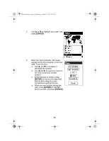
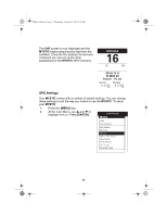
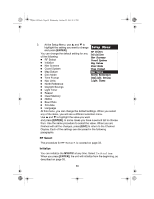
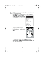
Mystic OM.book Page 59 Wednesday, October 22, 2003 8:59 PM Simulate If you select Simulate, all the features and the functions of the MYSTIC appear to operate. However, the readings are simulated, not real time data. You can simulate operations in one of two Modes: automatic, or manual. In either Mode, Track History will be cleared. 1. Select Simulate and press [ENTER]. 2. At the Simulate Menu, select Auto or User and press [ENTER]. a. If you select Auto, the MYSTIC will function with a predefined heading and speed. b. If you select User, you will be asked to define a desired simulated heading and speed. 3. To turn off Simulate, select Off and press [ENTER]. Nav Screens You can determine which navigation screens are displayed by selecting them individually from this Menu. The default is all screens On. Each time you press [ENTER], you see one of the navigation screens and a selection list. Select either On or Off to have that screen displayed or not. When you have finished with all navigation screens, you are returned to the Setup Menu. Coord System Allows you to set the coordinate system that will be used to display the position for the primary or secondary position screen. The available coordinate systems are: Lat/Lon, UTM, OSGB, Irish, Swiss, Swedish, Finnish, German, French, USNG, MGRS, or User Grid. The default for the primary position screen is Lat/Lon DEG.MIN.MMM. The default for the secondary position screen is UTM ((Universal Transverse Mercator. 59
-
 1
1 -
2
-
3
-
4
-
5
-
6
-
7
-
8
-
9
-
10
-
11
-
12
-
13
-
14
-
15
-
16
-
17
-
18
-
19
-
20
-
21
-
22
-
23
-
24
-
25
-
26
-
27
-
28
-
29
-
30
-
31
-
32
-
33
-
34
-
35
-
36
-
37
-
38
-
39
-
40
-
41
-
42
-
43
-
44
-
45
-
46
-
47
-
48
-
49
-
50
-
51
-
52
-
53
-
54
-
55
-
 56
56 -
 57
57 -
 58
58 -
 59
59 -
 60
60 -
 61
61 -
 62
62 -
 63
63 -
 64
64 -
 65
65 -
 66
66 -
67
-
68
-
69
-
70
-
71
-
72
-
73
-
74
-
75
-
76
-
77
-
78
-
79
-
80
-
81
-
82
-
83
-
84
-
85
-
86
-
87
-
88
-
89
-
90
-
91
-
92
-
93
-
94
-
95
-
96
-
97
-
98
-
99
-
100
-
101
-
102
-
103
-
104
-
105
-
106
-
107
-
108
-
109
-
110
-
111
-
112
-
113
-
114
-
115
-
116
-
117
-
118
-
119
-
120
-
121
-
122
-
123
-
124
-
125
-
126
-
127
-
128
-
129
-
130
-
131
-
132
 |
 |