Garmin GPSMAP 441s Owner's Manual - Page 4
Table of Contents, Introduction, Getting Started, Using Charts, Where To?, Viewing Information - marine navigator
 |
View all Garmin GPSMAP 441s manuals
Add to My Manuals
Save this manual to your list of manuals |
Page 4 highlights
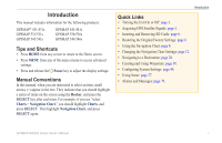
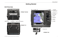
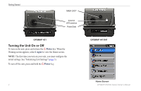
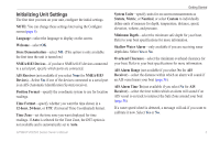
Introduction Table of Contents Introduction i Tips and Shortcuts i Manual Conventions i Quick Links i Declaration of Conformity (DoC iv Product Registration iv Contact Garmin iv Getting Started 1 Unit Overview 1 Turning the Unit On or Off 2 Initializing Unit Settings 3 Adjusting the Backlight 4 Using the Keypad 5 Acquiring GPS Satellite Signals 5 Using Simulator Mode 5 Viewing System Information 6 Restoring the Original Factory Settings 6 Inserting and Removing SD Cards 6 Understanding the Home Screen 7 Using Charts 8 Using the Navigation Chart 8 Changing the Navigation Chart Settings 12 Using the Split Navigation Chart 15 Using Perspective 3D 15 ii Using Mariner's Eye 3D 16 Using Fish Eye 3D 18 Using Fishing Charts 19 Enabling High Resolution Satellite Imagery 19 Viewing Aerial Photos 20 Animated Tide and Current Indicators 21 Detailed Road and POI Data 21 Using Automatic Guidance 22 Using the Chart/Sonar Screen 22 Automatic Identification System 22 Where To 28 Navigating to a Destination 28 Creating and Using Waypoints 30 Creating and Using Routes 31 Using Tracks 33 Using BlueChart g2 Vision 34 Navigating with a Garmin Autopilot 35 Viewing Information 36 Viewing a Compass 36 Viewing Numbers 36 Viewing Trip Information 37 Viewing and Customizing Engine Gauges 37 Viewing and Synchronizing Fuel Gauges 40 Viewing and Customizing Wind Gauges 41 Viewing Tide-station Information 42 Viewing Current Information 43 GPSMAP 400/500 Series Owner's Manual
-
 1
1 -
 2
2 -
 3
3 -
 4
4 -
 5
5 -
 6
6 -
 7
7 -
 8
8 -
 9
9 -
 10
10 -
11
-
12
-
13
-
14
-
15
-
16
-
17
-
18
-
19
-
20
-
21
-
22
-
23
-
24
-
25
-
26
-
27
-
28
-
29
-
30
-
31
-
32
-
33
-
34
-
35
-
36
-
37
-
38
-
39
-
40
-
41
-
42
-
43
-
44
-
45
-
46
-
47
-
48
-
49
-
50
-
51
-
52
-
53
-
54
-
55
-
56
-
57
-
58
-
59
-
60
-
61
-
62
-
63
-
64
-
65
-
66
-
67
-
68
-
69
-
70
-
71
-
72
-
73
-
74
-
75
-
76
-
77
-
78
-
79
-
80
-
81
-
82
-
83
-
84
-
85
-
86
-
87
-
88
-
89
-
90
-
91
-
92
-
93
-
94
-
95
-
96
 |
 |