Garmin Map 60 Owner's Manual - Page 63
Geocache Setup, Marine Setup
 |
UPC - 689076190107
View all Garmin Map 60 manuals
Add to My Manuals
Save this manual to your list of manuals |
Page 63 highlights
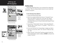
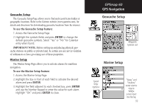
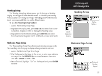
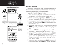
Geocache Setup The Geocache Setup Page allows you to find and record items hidden at geographic locations. Refer to the Garmin website (www.garmin.com), for details and directions for downloading geocache locations from the internet. To use the Geocache Setup feature: 1. Access the Geocache Setup Page. 2. Highlight the symbols fields and press ENTER to change the default geocache symbols. Select "Yes" or "No" for Calendar entry when found. IMPORTANT NOTE: Before setting up and placing physical geocache stations on public or private land, be certain you are not in violation of ordinances or laws governing use of these properties. Marine Setup The Marine Setup Page allows you to activate alarms for maritime navigation. To use the Marine Setup feature: 1. Access the Marine Setup Page. 2. Highlight the box in front of each field to activate the desired alarm and press ENTER. 3. Highlight the field adjacent to each checked box, press ENTER and use the Number Keypad to enter the value for each alarm. Highlight "OK" and press ENTER to close. GPSmap 60 GPS Navigation Geocache Setup Waypoint Symbols List Marine Setup Speed Filter Options "Deep" and "Shallow" water alarms require NMEA sonar input interfacing. 53
-
 1
1 -
2
-
3
-
4
-
5
-
6
-
7
-
8
-
9
-
10
-
11
-
12
-
13
-
14
-
15
-
16
-
17
-
18
-
19
-
20
-
21
-
22
-
23
-
24
-
25
-
26
-
27
-
28
-
29
-
30
-
31
-
32
-
33
-
34
-
35
-
36
-
37
-
38
-
39
-
40
-
41
-
42
-
43
-
44
-
45
-
46
-
47
-
48
-
49
-
50
-
51
-
52
-
53
-
54
-
55
-
56
-
57
-
 58
58 -
 59
59 -
 60
60 -
 61
61 -
 62
62 -
 63
63 -
 64
64 -
 65
65 -
 66
66 -
 67
67 -
 68
68 -
69
-
70
-
71
-
72
-
73
-
74
-
75
-
76
-
77
-
78
-
79
-
80
-
81
-
82
-
83
-
84
-
85
-
86
-
87
-
88
-
89
-
90
-
91
-
92
-
93
-
94
 |
 |