Nextar ME ME Software Manual - Page 85
Route Calculation Method or
 |
UPC - 714129881579
View all Nextar ME manuals
Add to My Manuals
Save this manual to your list of manuals |
Page 85 highlights
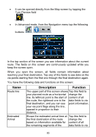
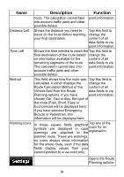
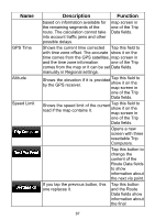
Name Distance Left Time Left Method Warning icons Description Function route. The calculation cannot take point information. into account traffic jams and other possible delays. Shows the distance you need to travel on the route before reaching your final destination. Tap this field to change the content of all data fields to via point information. Shows the time needed to reach the Tap this field to final destination of the route based change the on information available for the content of all remaining segments of the route. data fields to via The calculation cannot take into point information. account traffic jams and other possible delays. This field shows how the route was Tap this field to calculated. It either displays the change the Route Calculation Method or the content of all Vehicle field from the Route data fields to via Planning options. If you have point information. chosen Car, Taxi or Bus, the type of the route (Fast, Short, Easy or Economical) will be displayed here; if you have selected Emergency, Bicycle or Pedestrian, this information will be displayed here. In these symbols warnings square fields are displayed are attached graphical in case to the Tap any of the icons for an explanation. planned route. These are warnings, so icons always show information for the whole route, even if the data fields display values from your current position to a via point only. Opens the Route Planning options 84
-
 1
1 -
2
-
3
-
4
-
5
-
6
-
7
-
8
-
9
-
10
-
11
-
12
-
13
-
14
-
15
-
16
-
17
-
18
-
19
-
20
-
21
-
22
-
23
-
24
-
25
-
26
-
27
-
28
-
29
-
30
-
31
-
32
-
33
-
34
-
35
-
36
-
37
-
38
-
39
-
40
-
41
-
42
-
43
-
44
-
45
-
46
-
47
-
48
-
49
-
50
-
51
-
52
-
53
-
54
-
55
-
56
-
57
-
58
-
59
-
60
-
61
-
62
-
63
-
64
-
65
-
66
-
67
-
68
-
69
-
70
-
71
-
72
-
73
-
74
-
75
-
76
-
77
-
78
-
79
-
 80
80 -
 81
81 -
 82
82 -
 83
83 -
 84
84 -
 85
85 -
 86
86 -
 87
87 -
 88
88 -
 89
89 -
 90
90 -
91
-
92
-
93
-
94
-
95
-
96
-
97
-
98
-
99
-
100
-
101
-
102
-
103
-
104
-
105
-
106
-
107
-
108
-
109
-
110
-
111
-
112
-
113
-
114
-
115
-
116
-
117
-
118
-
119
-
120
-
121
-
122
-
123
-
124
-
125
-
126
-
127
 |
 |