Nextar ME ME Software Manual - Page 88
Route Data fields - gps manual
 |
UPC - 714129881579
View all Nextar ME manuals
Add to My Manuals
Save this manual to your list of manuals |
Page 88 highlights
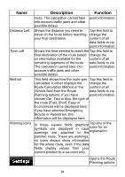
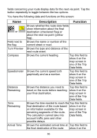
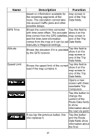
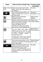
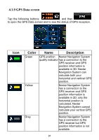
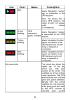
Name GPS Time Altitude Speed Limit Description Function based on information available for the remaining segments of the route. The calculation cannot take into account traffic jams and other possible delays. map screen in one of the Trip Data fields. Shows the current time corrected Tap this field to with time zone offset. The accurate show it on the time comes from the GPS satellites, map screen in and the time zone information one of the Trip comes from the map or it can be set Data fields. manually in Regional settings. Shows the elevation by the GPS receiver. if it is provided Tap this field to show it on the map screen in one of the Trip Data fields. Shows the speed limit of the road if the map contains it. current Tap this field to show it on the map screen in one of the Trip Data fields. Opens a new screen with three resettable Trip Computers. Tap this button to change the content of the Route Data fields to show information about the next via point. If you tap the previous button, this one replaces it. Tap this button and the Route Data fields show information about the final 87
-
 1
1 -
2
-
3
-
4
-
5
-
6
-
7
-
8
-
9
-
10
-
11
-
12
-
13
-
14
-
15
-
16
-
17
-
18
-
19
-
20
-
21
-
22
-
23
-
24
-
25
-
26
-
27
-
28
-
29
-
30
-
31
-
32
-
33
-
34
-
35
-
36
-
37
-
38
-
39
-
40
-
41
-
42
-
43
-
44
-
45
-
46
-
47
-
48
-
49
-
50
-
51
-
52
-
53
-
54
-
55
-
56
-
57
-
58
-
59
-
60
-
61
-
62
-
63
-
64
-
65
-
66
-
67
-
68
-
69
-
70
-
71
-
72
-
73
-
74
-
75
-
76
-
77
-
78
-
79
-
80
-
81
-
82
-
 83
83 -
 84
84 -
 85
85 -
 86
86 -
 87
87 -
 88
88 -
 89
89 -
 90
90 -
 91
91 -
 92
92 -
 93
93 -
94
-
95
-
96
-
97
-
98
-
99
-
100
-
101
-
102
-
103
-
104
-
105
-
106
-
107
-
108
-
109
-
110
-
111
-
112
-
113
-
114
-
115
-
116
-
117
-
118
-
119
-
120
-
121
-
122
-
123
-
124
-
125
-
126
-
127
 |
 |