Garmin eTrex Legend C Owner's Manual - Page 71
use Track Log Setup options
 |
UPC - 753759045555
View all Garmin eTrex Legend C manuals
Add to My Manuals
Save this manual to your list of manuals |
Page 71 highlights
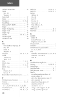
Index How To (Continued) change data fields 18 copy the route 36 create a reference note for a selected date 49 create a route 35 create a waypoint 24-25 delete a waypoint 27 delete the route 36 edit a waypoint 26 find an exit 30 find a city 30 find a Favorite 29 find a point of interest 32 find a waypoint 28 find details about a map item 12 find details about or Goto a map item 12 Goto a map item 12 hide Data Fields 13 hide Nav Status 13 hide or show Data Fields 13 insert a new waypoint on the route list 37 locate an address 32 locate an intersection 33 mark your current location as a waypoint 24 move a route waypoint 38 move a waypoint 25 navigate a route 39 program a data field 20 project a waypoint 26 remove all waypoints 36-37 restore default settings for the route 37 reverse the route 36 review a waypoint 37 review or remove a route waypoint 39 review the area of a saved track 51 save a Track Log 42 save Find Menu item as waypoints 27 save Map Menu item as waypoints 27 select a map page option 11 select a serial data format 46 select data field options 40 select Units Page options 44 Setup the Navigation Page 18 How To (Continued) set the backlighting timeout 45 set the date and time 43, 48, 49, 50 set the location 48, 50 show Data Fields 13 show Nav Status 13 stop navigating 13, 34, 40 transfer data 56 use Setup Map options 15 use the Measure Distance option 15 use Track Log Setup options 42 view the next waypoint in the route 39 Hunt and Fish 50 I Installing Batteries 3 Lanyard 2 Interface Page 46 Internal Antenna 2 L Land Cover 15 Land or Water 14 Language 47 LCD Display 2 Leg Course 40 Leg Distance 40 Leg Time 40 Location (lat/lon 54 Location (marking 24 Location (selected 54 Lock on Road 14 M Maintenance v Main Menu Page 4 Main Pages Main Menu 22 Map 9 Navigation 16 Satellite 5 Trip Computer 19, 20 Main Page Basics 4 61
-
 1
1 -
2
-
3
-
4
-
5
-
6
-
7
-
8
-
9
-
10
-
11
-
12
-
13
-
14
-
15
-
16
-
17
-
18
-
19
-
20
-
21
-
22
-
23
-
24
-
25
-
26
-
27
-
28
-
29
-
30
-
31
-
32
-
33
-
34
-
35
-
36
-
37
-
38
-
39
-
40
-
41
-
42
-
43
-
44
-
45
-
46
-
47
-
48
-
49
-
50
-
51
-
52
-
53
-
54
-
55
-
56
-
57
-
58
-
59
-
60
-
61
-
62
-
63
-
64
-
65
-
 66
66 -
 67
67 -
 68
68 -
 69
69 -
 70
70 -
 71
71 -
 72
72 -
 73
73 -
 74
74 -
 75
75 -
 76
76
 |
 |