Garmin eTrex Summit Owner's Manual - Page 59
Appendix B, What is GPS?
 |
View all Garmin eTrex Summit manuals
Add to My Manuals
Save this manual to your list of manuals |
Page 59 highlights
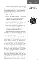
Appendicies The global positioning system is a satellite-based navigation system consisting of a network of 24 orbiting NAVSTAR satellites that are eleven thousand nautical miles in space and in six different orbital paths. The satellites are constantly moving, making two complete orbits around the Earth in less than 24 hours. A Little Satellite Info: • The first GPS satellite was launched in February, 1978. • Each satellite weighs about 2,000 pounds and is 17 feet across with the solar panels extended. • Transmitter power is only 50 watts, or less! • Each satellite transmits two signals, L1 and L2. Civilian GPS uses the 'L1' frequency of 1575.42 MHz. • Each satellite is expected to last approximately 10 years. Replacements are constantly being built and launched into orbit. The GPS program is currently funded with replacements through 2006. The orbital paths of these satellites take them between roughly 60 degrees North and 60 degrees South latitudes. What this means is you can receive satellite signals anywhere in the world, at any time. One of the biggest benefits over previous land-based navigation systems is GPS works in all weather conditions. No matter what your application, when you need it the most, your GPS receiver will keep right on working. So what information does a GPS satellite transmit? The GPS signal contains a 'pseudo-random code', ephemeris (pronounced: ee-fem-er-is) and almanac data. The pseudo-random code identifies which satellite is transmitting-in other words, an I.D. code. We refer to satellites by their PRN (pseudo-random number), from 1 through 32, and this is the number displayed on a GPS receiver to indicate which satellite(s) we are receiving. Ephemeris data contains important information such as satellite status (healthy or unhealthy), and the current date and time. The almanac data tells the GPS receiver where each GPS satellite should be at any time throughout the day. Each satellite transmits almanac data that provides orbital information for all of the satellites in the GPS network. Appendix B What is GPS? 57
-
 1
1 -
2
-
3
-
4
-
5
-
6
-
7
-
8
-
9
-
10
-
11
-
12
-
13
-
14
-
15
-
16
-
17
-
18
-
19
-
20
-
21
-
22
-
23
-
24
-
25
-
26
-
27
-
28
-
29
-
30
-
31
-
32
-
33
-
34
-
35
-
36
-
37
-
38
-
39
-
40
-
41
-
42
-
43
-
44
-
45
-
46
-
47
-
48
-
49
-
50
-
51
-
52
-
53
-
 54
54 -
 55
55 -
 56
56 -
 57
57 -
 58
58 -
 59
59 -
 60
60 -
 61
61 -
 62
62 -
 63
63 -
 64
64 -
65
-
66
-
67
-
68
-
69
-
70
-
71
-
72
-
73
 |
 |
