Garmin Astro Astro and DC 40 Owner's Manual - Page 29
Displaying Barometric, Pressure on the Altimeter, Viewing Points on the Altimeter
 |
UPC - 753759063931
View all Garmin Astro manuals
Add to My Manuals
Save this manual to your list of manuals |
Page 29 highlights
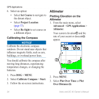
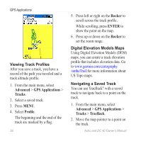
This option is only available when you are plotting elevation. After you set the elevation plot, you can adjust the zoom ranges ➍ (page 25). Displaying Barometric Pressure on the Altimeter 1. From the main menu, select Advanced > GPS Applications > Altimeter. 2. Press MENU. 3. Select View Pressure Plot. Viewing Points on the Altimeter Plot Select individual points on an elevation plot or a pressure plot to view the elevation (or pressure) reading, the time of day, and the date when the point was recorded. GPS Applications Navigating to a Point on the Plot 1. From the main menu, select Advanced > GPS Applications > Altimeter. 2. Press left or right on the Rocker to display crosshairs and scroll the crosshairs across the plot. 3. Press ENTER. The point appears on the map with location coordinates, the compass bearing, and the distance from your current location. 4. Press MARK to save the point as a location. 5. Navigate to the location (page 18). Setting the Zoom Ranges 1. From the main menu, select Advanced > GPS Applications > Altimeter. 2. Press MENU. 3. Select Zoom Ranges. Astro and DC 40 Owner's Manual 25
-
 1
1 -
2
-
3
-
4
-
5
-
6
-
7
-
8
-
9
-
10
-
11
-
12
-
13
-
14
-
15
-
16
-
17
-
18
-
19
-
20
-
21
-
22
-
23
-
 24
24 -
 25
25 -
 26
26 -
 27
27 -
 28
28 -
 29
29 -
 30
30 -
 31
31 -
 32
32 -
 33
33 -
 34
34 -
35
-
36
-
37
-
38
-
39
-
40
-
41
-
42
-
43
-
44
-
45
-
46
-
47
-
48
-
49
-
50
-
51
-
52
-
53
-
54
-
55
-
56
-
57
-
58
-
59
-
60
-
61
-
62
-
63
-
64
-
65
-
66
-
67
-
68
-
69
-
70
-
71
-
72
-
73
-
74
-
75
-
76
-
77
-
78
-
79
-
80
-
81
-
82
-
83
-
84
 |
 |
