Garmin Forerunner 265S Owners Manual - Page 111
Distance Fields, Elevation Fields, Floors Fields, Last Lap Descent
 |
View all Garmin Forerunner 265S manuals
Add to My Manuals
Save this manual to your list of manuals |
Page 111 highlights
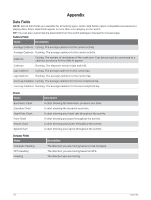
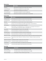
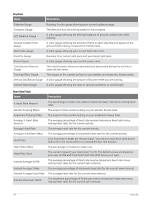
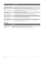
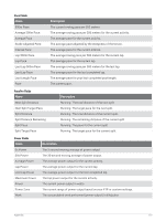
Distance Fields Name Distance Interval Distance Lap Distance Last Lap Distance Nautical Distance Description The distance traveled for the current track or activity. The distance traveled for the current interval. The distance traveled for the current lap. The distance traveled for the last completed lap. The distance traveled in nautical meters or nautical feet. Elevation Fields Name Description Average Ascent The average vertical distance of ascent since the last reset. Average Descent The average vertical distance of descent since the last reset. Elevation The altitude of your current location above or below sea level. Glide Ratio The ratio of horizontal distance traveled to the change in vertical distance. GPS Elevation The altitude of your current location using GPS. Grade The calculation of rise (elevation) over run (distance). For example, if for every 3 m (10 ft.) you climb you travel 60 m (200 ft.), the grade is 5%. Lap Ascent The vertical distance of ascent for the current lap. Lap Descent The vertical distance of descent for the current lap. Last Lap Ascent The vertical distance of ascent for the last completed lap. Last Lap Descent The vertical distance of descent for the last completed lap. Maximum Ascent The maximum rate of ascent in feet per minute or meters per minute since the last reset. Maximum Descent The maximum rate of descent in meters per minute or feet per minute since the last reset. Maximum Elevation The highest elevation reached since the last reset. Minimum Elevation The lowest elevation reached since the last reset. Total Ascent The total elevation distance ascended since the last reset. Total Descent The total elevation distance descended since the last reset. Floors Fields Name Floors Climbed Floors Descended Floors per Minute Description The total number of floors climbed up for the day. The total number of floors climbed down for the day. The number of floors climbed up per minute. Appendix 103
-
 1
1 -
2
-
3
-
4
-
5
-
6
-
7
-
8
-
9
-
10
-
11
-
12
-
13
-
14
-
15
-
16
-
17
-
18
-
19
-
20
-
21
-
22
-
23
-
24
-
25
-
26
-
27
-
28
-
29
-
30
-
31
-
32
-
33
-
34
-
35
-
36
-
37
-
38
-
39
-
40
-
41
-
42
-
43
-
44
-
45
-
46
-
47
-
48
-
49
-
50
-
51
-
52
-
53
-
54
-
55
-
56
-
57
-
58
-
59
-
60
-
61
-
62
-
63
-
64
-
65
-
66
-
67
-
68
-
69
-
70
-
71
-
72
-
73
-
74
-
75
-
76
-
77
-
78
-
79
-
80
-
81
-
82
-
83
-
84
-
85
-
86
-
87
-
88
-
89
-
90
-
91
-
92
-
93
-
94
-
95
-
96
-
97
-
98
-
99
-
100
-
101
-
102
-
103
-
104
-
105
-
 106
106 -
 107
107 -
 108
108 -
 109
109 -
 110
110 -
 111
111 -
 112
112 -
 113
113 -
 114
114 -
 115
115 -
 116
116 -
117
-
118
-
119
-
120
-
121
-
122
 |
 |