ii
GPSMAP 400/500 Series Owner’s Manual
Introduction
Table of Contents
Introduction�����������������������������������������������������������������������������
i
Tips and Shortcuts ���������������������������������������������������������������������������
i
Manual Conventions ������������������������������������������������������������������������
i
Quick Links ��������������������������������������������������������������������������������������
i
Declaration of Conformity (DoC) ����������������������������������������������������
iv
Product Registration ����������������������������������������������������������������������
iv
Contact Garmin ������������������������������������������������������������������������������
iv
Getting Started�����������������������������������������������������������������������
1
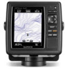
Unit Overview����������������������������������������������������������������������������������
1
Turning the Unit On or Off ���������������������������������������������������������������
2
Initializing Unit Settings �������������������������������������������������������������������
2
Adjusting the Backlight��������������������������������������������������������������������
3
Using the Keypad����������������������������������������������������������������������������
4
Acquiring GPS Satellite Signals ������������������������������������������������������
5
Using Simulator Mode���������������������������������������������������������������������
5
Inserting and Removing SD Cards �������������������������������������������������
5
Understanding the Home Screen����������������������������������������������������
6
Using Charts ��������������������������������������������������������������������������
7
Using the Navigation Chart �������������������������������������������������������������
7
Changing the Navigation Chart Settings ���������������������������������������
11
Using the Split Navigation Chart ���������������������������������������������������
14
Using Perspective 3D �������������������������������������������������������������������
14
Using Mariner’s Eye 3D ����������������������������������������������������������������
15
Using Fish Eye 3D ������������������������������������������������������������������������
17
Using Fishing Charts���������������������������������������������������������������������
17
Enabling High Resolution Satellite Imagery ����������������������������������
18
Viewing Aerial Photos �������������������������������������������������������������������
19
Animated Tide and Current Indicators ������������������������������������������
20
Detailed Road and POI Data ��������������������������������������������������������
21
Using Automatic Guidance������������������������������������������������������������
21
Using the Chart/Sonar Screen ������������������������������������������������������
22
Where To? ����������������������������������������������������������������������������
23
Navigating to a Destination �����������������������������������������������������������
23
Creating and Using Waypoints������������������������������������������������������
25
Creating and Using Routes �����������������������������������������������������������
26
Using Tracks ���������������������������������������������������������������������������������
28
Using BlueChart g2 Vision ������������������������������������������������������������
30
Navigating with a Garmin Autopilot �����������������������������������������������
30
Viewing Information ������������������������������������������������������������
31
Viewing a Compass ����������������������������������������������������������������������
31
Viewing Numbers ��������������������������������������������������������������������������
31
Viewing Trip Information ���������������������������������������������������������������
32
Viewing and Customizing Fuel Gauges and Engine Gauges �������
32
Viewing and Customizing Wind Gauges ���������������������������������������
36
Viewing Tide-station Information ���������������������������������������������������
37
Viewing Current Information ���������������������������������������������������������
38
Viewing Celestial Information��������������������������������������������������������
38
Viewing User Data ������������������������������������������������������������������������
39
Viewing Other Vessels ������������������������������������������������������������������
41
Automatic Identification System ����������������������������������������������������
41
 1
1 2
2 3
3 4
4 5
5 6
6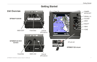 7
7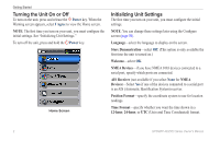 8
8 9
9 10
10