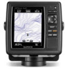
Garmin GPSMAP 527 Owner's Manual - Page 82
Save To Card, Serial Port setup
 |
View all Garmin GPSMAP 527 manuals
Add to My Manuals
Save this manual to your list of manuals |
Page 82 highlights
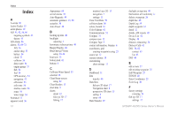
Index route to 23 S safe-zone settings 56 Safe Depth 16, 50 Safe Height 50 Safety Shading 13 sailing data bar 9 SART 42 satellite imagery enabling 18 Saved Tracks 15 Save To Card 40, 48 screenshots 72 scroll speed 60 SD cards inserting 5 removing 5 SELECT key 4 Serial Port setup 51 Service Points 11 settings alarms 53 chart 11 communications 51 fish eye 3D 17 initializing 2 language 49 navigation preferences 50 system 48 76 units of measure 49 Shoreline Distance 50 simulator 48 mode 5 Skyview 48 software license agreement 73 software version 48 sonar advanced settings 61 cone 17 full screen 57 scroll speed 60 setting up 60-61 setup 60 specifications 68 split frequency 58 split zoom 58 temperature log 59 specifications 67 Speed Filter 48 Speed Sources 50 Split Frequency 58 Split Zoom 58 spot depths 13 Surface Noise 60 symbols 13 System Alarms 53 System Information 48 viewing 48 system settings 48 System Units 49 T Temp Log 59 Temp Offset 55 Tides/Currents 11 Animated 11 tide stations 37 viewing information 11 Time (options) 49 tracks 17, 28 trails AIS 45 DSC 65 transducer dual frequency 61 transferring data 39, 40 True (north) 49 true wind 36 turn the unit off 2 Turn Transition 50 U unit ID number 48 units of measure 49 user data backing up 40 clearing 39 transferring 40 viewing 39 V Vehicle Icon 13 version (software) 48 VHF radio 62 viewing currents 38 other boats 41 tide stations 37 user data 39 W WAAS 48 water temperature 70 Waypoint IDs 52 waypoints 15 creating 25 deleting 25, 26 depth 61 edit existing 15, 25 mark current location 25 moving 25 viewing 39 Where To 23 Whiteline 60 wind gauge 36 close hauled 36, 37 Z zoom 61 2x 61 GPSMAP 400/500 Series Owner's Manual
-
 1
1 -
2
-
3
-
4
-
5
-
6
-
7
-
8
-
9
-
10
-
11
-
12
-
13
-
14
-
15
-
16
-
17
-
18
-
19
-
20
-
21
-
22
-
23
-
24
-
25
-
26
-
27
-
28
-
29
-
30
-
31
-
32
-
33
-
34
-
35
-
36
-
37
-
38
-
39
-
40
-
41
-
42
-
43
-
44
-
45
-
46
-
47
-
48
-
49
-
50
-
51
-
52
-
53
-
54
-
55
-
56
-
57
-
58
-
59
-
60
-
61
-
62
-
63
-
64
-
65
-
66
-
67
-
68
-
69
-
70
-
71
-
72
-
73
-
74
-
75
-
76
-
 77
77 -
 78
78 -
 79
79 -
 80
80 -
 81
81 -
 82
82 -
 83
83 -
 84
84
 |
 |