Garmin GPSMAP 527 Owner's Manual - Page 81
Points of Interest POI, Garmin Data Transfer
 |
View all Garmin GPSMAP 527 manuals
Add to My Manuals
Save this manual to your list of manuals |
Page 81 highlights
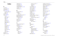
Fishing 9 fishing chart 17 Fish Symbols 17, 60 frequency 61 Fuel Capacity 56 fuel gauge 35 full screen, sonar 57 fuse 68 G gain 61 Garmin Data Transfer 51 go to 23 GPS 5, 48, 68 GPS heading 37 Grid (North) 49 grid coordinates creating waypoints using 25 ground wind 36 guide to 23 H Hazard Colors 16 heading 49 GPS 37 magnetic 37 Heading Line 13 heading source 37 Head Up 12 HOME key 4 I icon 13 ID number 48 K keel offset 55 keypad 4 L Label Devices 52 Lane Width 15, 17 Language 49 Light Sectors 13 M magnetic heading 37 Man Overboard 25, 64 Manual Zoom 61 map datum 49 MapSource data 39 mariner's eye 3D 15 colors 16 mark current location 25 measuring distance 26 MENU key 5 messages 69 move a waypoint 25 My Boat 55 N Navaid Size 13 GPSMAP 400/500 Series Owner's Manual Navaid Type 13 Navigate To 10, 24, 26, 27, 65 Navigation Alarms 53 navigation charts 7 navigation preferences 50 New Waypoint 15 NMEA 0183 Setup 52 NMEA 2000 Setup 52 NMEA High Speed 51 NMEA Standard 51 Noise Reject 61 north grid 49 magnetic 49 true 49 north up 12 No Zoom 61 numbers customizing 31 overlay numbers 9 viewing 31 O object information accessing 11 Other Vessels 56 P Pause Sonar 61 Perspective 3D 14 Index Photo Points 13 photos 11 physical specifications 67 Points of Interest (POI) 13, 21, 30 Position Format 49 position reports 64 position tracking 64 Posn. Precision 52 Power/Backlight key 4 power source 68 product registration iv Q quick links i R radio 62 Range (sonar) 61 Range keys 4 Range Rings 15, 16 registering your product iv restoring factory settings 56 Rocker key 4 Roses 12 routes creating 26 deleting 28 editing 27 labels 50 viewing 39 75
-
 1
1 -
2
-
3
-
4
-
5
-
6
-
7
-
8
-
9
-
10
-
11
-
12
-
13
-
14
-
15
-
16
-
17
-
18
-
19
-
20
-
21
-
22
-
23
-
24
-
25
-
26
-
27
-
28
-
29
-
30
-
31
-
32
-
33
-
34
-
35
-
36
-
37
-
38
-
39
-
40
-
41
-
42
-
43
-
44
-
45
-
46
-
47
-
48
-
49
-
50
-
51
-
52
-
53
-
54
-
55
-
56
-
57
-
58
-
59
-
60
-
61
-
62
-
63
-
64
-
65
-
66
-
67
-
68
-
69
-
70
-
71
-
72
-
73
-
74
-
75
-
 76
76 -
 77
77 -
 78
78 -
 79
79 -
 80
80 -
 81
81 -
 82
82 -
 83
83 -
 84
84
 |
 |