Garmin aera 796 Pilot's Guide - Page 111
Terrain and Obstacle Color Code, Enabling/Disabling Terrain Shading on the Navigation Map
 |
View all Garmin aera 796 manuals
Add to My Manuals
Save this manual to your list of manuals |
Page 111 highlights
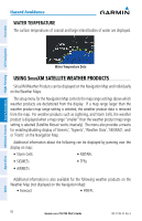
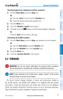
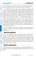
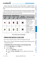
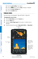
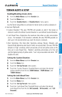
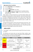
Hazard Avoidance Overview GPS Navigation Standard aeronautical chart symbols are used for lighted or unlighted obstacles taller than 200 feet Above Ground Level (AGL). Refer to the Obstacle Icons legend below. When selecting an obstacle with the Map Pointer, each obstacle displays the altitude at the top of the obstacle, or Mean Sea Level (MSL). Each obstacle also lists the actual height of the obstacle, or Above Ground Level (AGL). Unlighted Obstacle Lighted Obstacle < 1000' > 1000' Potential < 1000' > 1000' Impact Points Obstacle Location AGL AGL AGL AGL WARNING: Red obstacle is above or within 100' below current aircraft altitude CAUTION: Yellow obstacle is between 100' and 1000' below current aircraft altitude Flight Planning Hazard Avoidance Additional Features Terrain Obstacle Colors and Symbology Appendices TERRAIN AND OBSTACLE COLOR CODE Red-terrain or obstacle is above or within 100 feet below the aircraft. Yellow-terrain or obstacle is between the user-defined Caution Elevation and 100 feet below the aircraft. Enabling/Disabling Terrain Shading on the Navigation Map: 1) From the Main Menu touch the Map Icon. 2) Touch the Menu Icon. a) Touch the 'Show/Hide...' menu option. b) Touch the Terrain 'Show/Hide' Button to toggle the terrain overlay on/off. Or: 190-01194-00 Rev. A Garmin aera 795/796 Pilot's Guide 97 Index
-
 1
1 -
2
-
3
-
4
-
5
-
6
-
7
-
8
-
9
-
10
-
11
-
12
-
13
-
14
-
15
-
16
-
17
-
18
-
19
-
20
-
21
-
22
-
23
-
24
-
25
-
26
-
27
-
28
-
29
-
30
-
31
-
32
-
33
-
34
-
35
-
36
-
37
-
38
-
39
-
40
-
41
-
42
-
43
-
44
-
45
-
46
-
47
-
48
-
49
-
50
-
51
-
52
-
53
-
54
-
55
-
56
-
57
-
58
-
59
-
60
-
61
-
62
-
63
-
64
-
65
-
66
-
67
-
68
-
69
-
70
-
71
-
72
-
73
-
74
-
75
-
76
-
77
-
78
-
79
-
80
-
81
-
82
-
83
-
84
-
85
-
86
-
87
-
88
-
89
-
90
-
91
-
92
-
93
-
94
-
95
-
96
-
97
-
98
-
99
-
100
-
101
-
102
-
103
-
104
-
105
-
 106
106 -
 107
107 -
 108
108 -
 109
109 -
 110
110 -
 111
111 -
 112
112 -
 113
113 -
 114
114 -
 115
115 -
 116
116 -
117
-
118
-
119
-
120
-
121
-
122
-
123
-
124
-
125
-
126
-
127
-
128
-
129
-
130
-
131
-
132
-
133
-
134
-
135
-
136
-
137
-
138
-
139
-
140
-
141
-
142
-
143
-
144
-
145
-
146
-
147
-
148
-
149
-
150
-
151
-
152
-
153
-
154
-
155
-
156
-
157
-
158
-
159
-
160
-
161
-
162
-
163
-
164
-
165
-
166
-
167
-
168
-
169
-
170
-
171
-
172
-
173
-
174
-
175
-
176
-
177
-
178
-
179
-
180
-
181
-
182
-
183
-
184
-
185
-
186
-
187
-
188
-
189
-
190
-
191
-
192
-
193
-
194
-
195
-
196
-
197
-
198
-
199
-
200
-
201
-
202
-
203
-
204
-
205
-
206
-
207
-
208
-
209
-
210
 |
 |