Garmin aera 796 Pilot's Guide - Page 98
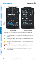
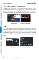
arrow is displayed depends on the storm cell's speed., The map range at which
 |
View all Garmin aera 796 manuals
Add to My Manuals
Save this manual to your list of manuals |
Page 98 highlights
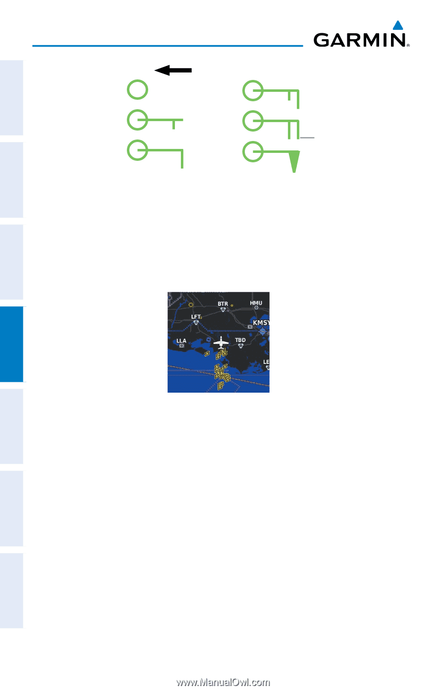
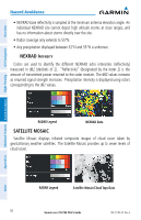
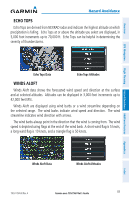
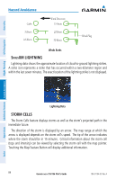
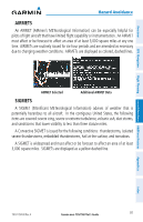
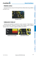
Overview GPS Navigation Hazard Avoidance Calm 5 Knots 10 Knots Wind Direction 15 Knots 20 Knots 50 Knots Wind Flag Winds Barbs SiriusXM LIGHTNING Lightning data shows the approximate location of cloud-to-ground lightning strikes. A strike icon represents a strike that has occurred within a two-kilometer region and within the last seven minutes. The exact location of the lightning strike is not displayed. Additional Features Hazard Avoidance Flight Planning Appendices Lightning Data STORM CELLS The Storm Cells feature displays storms as well as the storm's projected path in the immediate future. The direction of the storm is displayed by an arrow. The map range at which the arrow is displayed depends on the storm cell's speed. The tip of the arrow indicates where the storm should be in 15 minutes. Critical information about the storm cell (tops and intensity) can be viewed by selecting the storm cell with the map pointer. Touching the Map Feature Button will display additional information. 84 Garmin aera 795/796 Pilot's Guide 190-01194-00 Rev. A Index
-
 1
1 -
2
-
3
-
4
-
5
-
6
-
7
-
8
-
9
-
10
-
11
-
12
-
13
-
14
-
15
-
16
-
17
-
18
-
19
-
20
-
21
-
22
-
23
-
24
-
25
-
26
-
27
-
28
-
29
-
30
-
31
-
32
-
33
-
34
-
35
-
36
-
37
-
38
-
39
-
40
-
41
-
42
-
43
-
44
-
45
-
46
-
47
-
48
-
49
-
50
-
51
-
52
-
53
-
54
-
55
-
56
-
57
-
58
-
59
-
60
-
61
-
62
-
63
-
64
-
65
-
66
-
67
-
68
-
69
-
70
-
71
-
72
-
73
-
74
-
75
-
76
-
77
-
78
-
79
-
80
-
81
-
82
-
83
-
84
-
85
-
86
-
87
-
88
-
89
-
90
-
91
-
92
-
 93
93 -
 94
94 -
 95
95 -
 96
96 -
 97
97 -
 98
98 -
 99
99 -
 100
100 -
 101
101 -
 102
102 -
 103
103 -
104
-
105
-
106
-
107
-
108
-
109
-
110
-
111
-
112
-
113
-
114
-
115
-
116
-
117
-
118
-
119
-
120
-
121
-
122
-
123
-
124
-
125
-
126
-
127
-
128
-
129
-
130
-
131
-
132
-
133
-
134
-
135
-
136
-
137
-
138
-
139
-
140
-
141
-
142
-
143
-
144
-
145
-
146
-
147
-
148
-
149
-
150
-
151
-
152
-
153
-
154
-
155
-
156
-
157
-
158
-
159
-
160
-
161
-
162
-
163
-
164
-
165
-
166
-
167
-
168
-
169
-
170
-
171
-
172
-
173
-
174
-
175
-
176
-
177
-
178
-
179
-
180
-
181
-
182
-
183
-
184
-
185
-
186
-
187
-
188
-
189
-
190
-
191
-
192
-
193
-
194
-
195
-
196
-
197
-
198
-
199
-
200
-
201
-
202
-
203
-
204
-
205
-
206
-
207
-
208
-
209
-
210
 |
 |