Garmin aera 796 Pilot's Guide - Page 66
Textual Weather Information, Viewing textual airport weather information
 |
View all Garmin aera 796 manuals
Add to My Manuals
Save this manual to your list of manuals |
Page 66 highlights
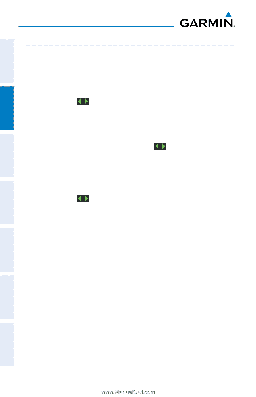
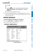
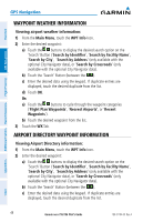
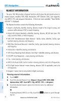
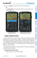
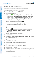
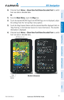
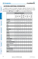
Overview GPS Navigation Additional Features Hazard Avoidance Flight Planning GPS Navigation TEXTUAL WEATHER INFORMATION Textual weather information can be viewed several different ways. Viewing textual airport weather information: 1) From the Main Menu, touch the WPT Info Icon. 2) Enter the desired waypoint: a) Touch the buttons to display the desired search option on the 'Search' Button ('Search by Identifier', 'Search by Facility Name', 'Search by City', 'Search by Address' (only available with the optional City Navigator data), or 'Search by Crossroads' (only available with the optional City Navigator data). b) Touch the 'Search' Button (between the ). c) Enter the desired data using the keypad. If duplicate entries are displayed, touch the desired duplicate from the list. d) Touch OK. Or: a) Touch the buttons to cycle through the waypoint categories ('Flight Plan Waypoints', 'Nearest Airports', or 'Recent Waypoints'). b) Touch the desired waypoint from the list. 3) Touch the WX Tab. 4) If desired touch Menu > Show Raw Text/Show Decoded Text to switch from raw data to decoded data. Or: 1) Touch NRST > Airport WX. 2) Touch the desired Nearest Airport Weather from the list. Or: 1) From the Main Menu, touch the Weather > METAR. 2) Touch the desired METAR flag. 3) Touch the Map Feature Button with the desired identifier displayed (refer to 'Map Panning' in the Overview Section for more information). The weather information is displayed. Appendices Index 52 Garmin aera 795/796 Pilot's Guide 190-01194-00 Rev. A
-
 1
1 -
2
-
3
-
4
-
5
-
6
-
7
-
8
-
9
-
10
-
11
-
12
-
13
-
14
-
15
-
16
-
17
-
18
-
19
-
20
-
21
-
22
-
23
-
24
-
25
-
26
-
27
-
28
-
29
-
30
-
31
-
32
-
33
-
34
-
35
-
36
-
37
-
38
-
39
-
40
-
41
-
42
-
43
-
44
-
45
-
46
-
47
-
48
-
49
-
50
-
51
-
52
-
53
-
54
-
55
-
56
-
57
-
58
-
59
-
60
-
 61
61 -
 62
62 -
 63
63 -
 64
64 -
 65
65 -
 66
66 -
 67
67 -
 68
68 -
 69
69 -
 70
70 -
 71
71 -
72
-
73
-
74
-
75
-
76
-
77
-
78
-
79
-
80
-
81
-
82
-
83
-
84
-
85
-
86
-
87
-
88
-
89
-
90
-
91
-
92
-
93
-
94
-
95
-
96
-
97
-
98
-
99
-
100
-
101
-
102
-
103
-
104
-
105
-
106
-
107
-
108
-
109
-
110
-
111
-
112
-
113
-
114
-
115
-
116
-
117
-
118
-
119
-
120
-
121
-
122
-
123
-
124
-
125
-
126
-
127
-
128
-
129
-
130
-
131
-
132
-
133
-
134
-
135
-
136
-
137
-
138
-
139
-
140
-
141
-
142
-
143
-
144
-
145
-
146
-
147
-
148
-
149
-
150
-
151
-
152
-
153
-
154
-
155
-
156
-
157
-
158
-
159
-
160
-
161
-
162
-
163
-
164
-
165
-
166
-
167
-
168
-
169
-
170
-
171
-
172
-
173
-
174
-
175
-
176
-
177
-
178
-
179
-
180
-
181
-
182
-
183
-
184
-
185
-
186
-
187
-
188
-
189
-
190
-
191
-
192
-
193
-
194
-
195
-
196
-
197
-
198
-
199
-
200
-
201
-
202
-
203
-
204
-
205
-
206
-
207
-
208
-
209
-
210
 |
 |