Garmin aera 796 Pilot's Guide - Page 68
Accessing Additional information, Additional Information
 |
View all Garmin aera 796 manuals
Add to My Manuals
Save this manual to your list of manuals |
Page 68 highlights
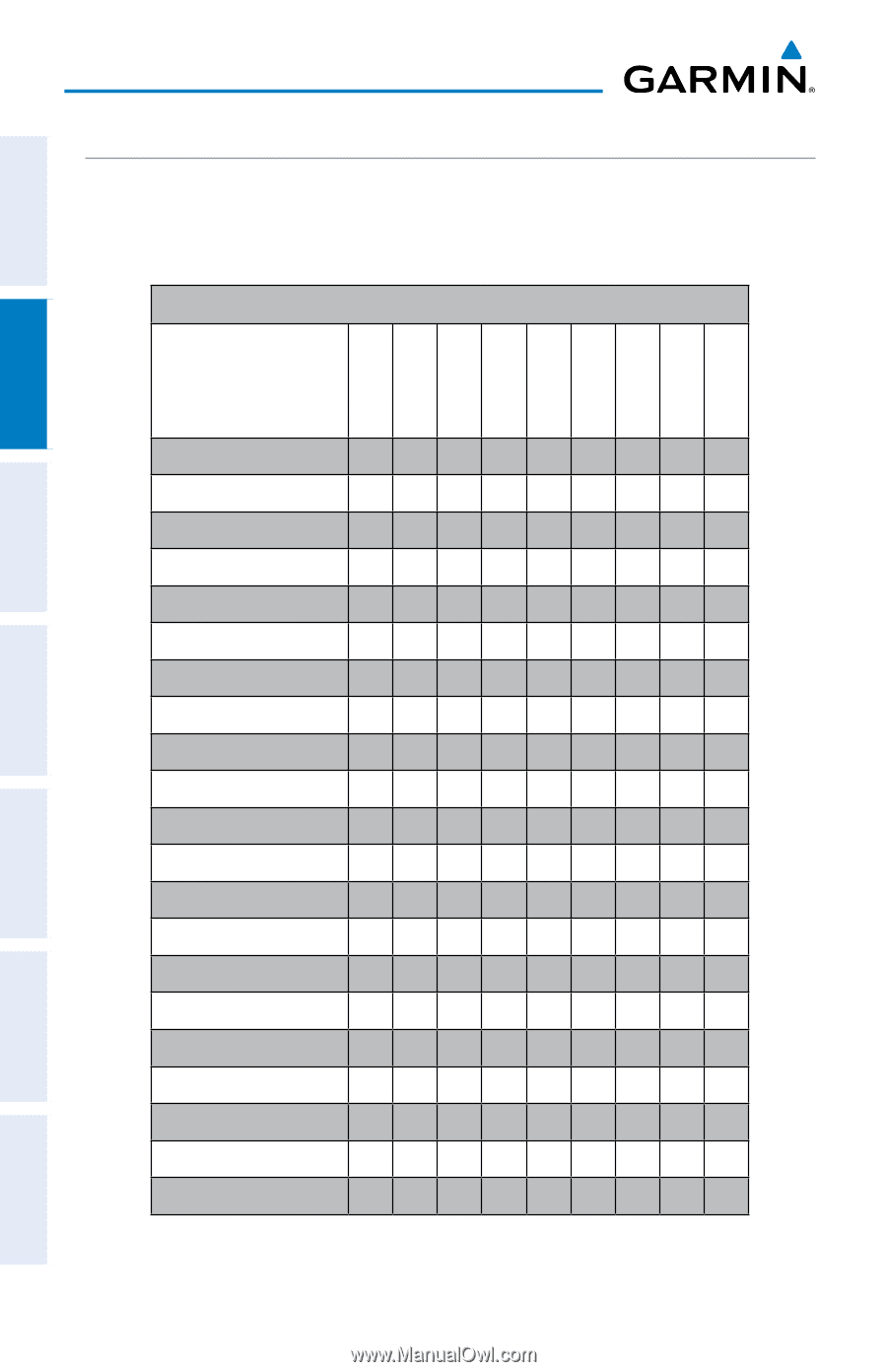
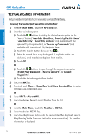
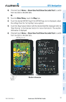
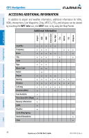
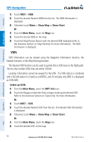
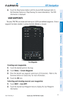
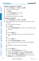
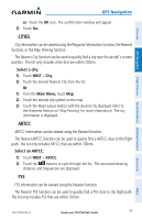
Overview GPS Navigation ACCESSING ADDITIONAL INFORMATION In addition to airport and weather information, additional information for VORs, NDBs, Intersections, User Waypoints, Cities, ARTCCs, FSSs, and Airspace can be viewed by touching the WPT Info Icon, the NRST Icon, or by using the Map Pointer. Additional Information Airport VOR NDB Intersection User Wpt City ARTCC FSS Airspace GPS Navigation Additional Features Hazard Avoidance Flight Planning Identifier +++++ Frequency +++ +++ Name +++++ + City +++ + + State +++ + Type +++ Morse Code ++ Radial + Region +++++ Bearing ++++++++ Distance +++++++++ Lat/Long ++++++ Elevation (MSL) + + Fuel Available + Time Zone (UTC Offset) + Runway Information + AOPA + Weather + Controlling Agency + Vertical Boundaries + Class + 54 Garmin aera 795/796 Pilot's Guide 190-01194-00 Rev. A Appendices Index
-
 1
1 -
2
-
3
-
4
-
5
-
6
-
7
-
8
-
9
-
10
-
11
-
12
-
13
-
14
-
15
-
16
-
17
-
18
-
19
-
20
-
21
-
22
-
23
-
24
-
25
-
26
-
27
-
28
-
29
-
30
-
31
-
32
-
33
-
34
-
35
-
36
-
37
-
38
-
39
-
40
-
41
-
42
-
43
-
44
-
45
-
46
-
47
-
48
-
49
-
50
-
51
-
52
-
53
-
54
-
55
-
56
-
57
-
58
-
59
-
60
-
61
-
62
-
 63
63 -
 64
64 -
 65
65 -
 66
66 -
 67
67 -
 68
68 -
 69
69 -
 70
70 -
 71
71 -
 72
72 -
 73
73 -
74
-
75
-
76
-
77
-
78
-
79
-
80
-
81
-
82
-
83
-
84
-
85
-
86
-
87
-
88
-
89
-
90
-
91
-
92
-
93
-
94
-
95
-
96
-
97
-
98
-
99
-
100
-
101
-
102
-
103
-
104
-
105
-
106
-
107
-
108
-
109
-
110
-
111
-
112
-
113
-
114
-
115
-
116
-
117
-
118
-
119
-
120
-
121
-
122
-
123
-
124
-
125
-
126
-
127
-
128
-
129
-
130
-
131
-
132
-
133
-
134
-
135
-
136
-
137
-
138
-
139
-
140
-
141
-
142
-
143
-
144
-
145
-
146
-
147
-
148
-
149
-
150
-
151
-
152
-
153
-
154
-
155
-
156
-
157
-
158
-
159
-
160
-
161
-
162
-
163
-
164
-
165
-
166
-
167
-
168
-
169
-
170
-
171
-
172
-
173
-
174
-
175
-
176
-
177
-
178
-
179
-
180
-
181
-
182
-
183
-
184
-
185
-
186
-
187
-
188
-
189
-
190
-
191
-
192
-
193
-
194
-
195
-
196
-
197
-
198
-
199
-
200
-
201
-
202
-
203
-
204
-
205
-
206
-
207
-
208
-
209
-
210
 |
 |