Garmin aera 796 Pilot's Guide - Page 144
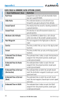
Estimated Time En Route, Estimated Time of Arrival
 |
View all Garmin aera 796 manuals
Add to My Manuals
Save this manual to your list of manuals |
Page 144 highlights
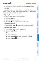
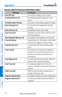
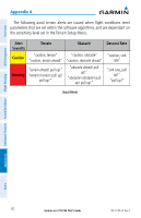
Overview GPS Navigation Additional Features Hazard Avoidance Flight Planning Appendix A DATA FIELD & NUMERIC DATA OPTIONS (CONT.) Data Field/Numeric Data Definition Fuel Timer Elapsed time since the Fuel Tank Reminder Alarm was last issued (HH:MM). Glide Ratio The estimated distance an aircraft will move forward for any given amount of lost altitude. Ground Speed The velocity that the aircraft is traveling relative to a ground position. Ground Track The direction of aircraft movement relative to a ground position. Minimum Safe Altitude Uses Grid MORAs to determine a safe altitude within ten miles of the aircraft's present position. Next Waypoint The next waypoint in the flight plan or direct-to route. Sunrise The time at which the sun rises on this day (current location). Sunset The time at which the sun sets on this day (current location). Estimated Time En Route (Destination) The estimated time it takes to reach the destination waypoint from the present position, based upon current ground speed. Estimated Time En Route (Next) The estimated time it takes to reach the next waypoint form the present position, based upon current ground speed. Estimated Time of Arrival (Destination) The estimated time at which the aircraft should reach the destination waypoint, based upon current speed and track. Estimated Time of Arrival (Next) The estimated time at which the aircraft should reach the next waypoint, based upon current speed and track. Estimated Time to VNAV The estimated time it takes to reach the VNAV waypoint form the present position, based upon current ground speed. Appendices Index 130 Garmin aera 795/796 Pilot's Guide 190-01194-00 Rev. A
-
 1
1 -
2
-
3
-
4
-
5
-
6
-
7
-
8
-
9
-
10
-
11
-
12
-
13
-
14
-
15
-
16
-
17
-
18
-
19
-
20
-
21
-
22
-
23
-
24
-
25
-
26
-
27
-
28
-
29
-
30
-
31
-
32
-
33
-
34
-
35
-
36
-
37
-
38
-
39
-
40
-
41
-
42
-
43
-
44
-
45
-
46
-
47
-
48
-
49
-
50
-
51
-
52
-
53
-
54
-
55
-
56
-
57
-
58
-
59
-
60
-
61
-
62
-
63
-
64
-
65
-
66
-
67
-
68
-
69
-
70
-
71
-
72
-
73
-
74
-
75
-
76
-
77
-
78
-
79
-
80
-
81
-
82
-
83
-
84
-
85
-
86
-
87
-
88
-
89
-
90
-
91
-
92
-
93
-
94
-
95
-
96
-
97
-
98
-
99
-
100
-
101
-
102
-
103
-
104
-
105
-
106
-
107
-
108
-
109
-
110
-
111
-
112
-
113
-
114
-
115
-
116
-
117
-
118
-
119
-
120
-
121
-
122
-
123
-
124
-
125
-
126
-
127
-
128
-
129
-
130
-
131
-
132
-
133
-
134
-
135
-
136
-
137
-
138
-
 139
139 -
 140
140 -
 141
141 -
 142
142 -
 143
143 -
 144
144 -
 145
145 -
 146
146 -
 147
147 -
 148
148 -
 149
149 -
150
-
151
-
152
-
153
-
154
-
155
-
156
-
157
-
158
-
159
-
160
-
161
-
162
-
163
-
164
-
165
-
166
-
167
-
168
-
169
-
170
-
171
-
172
-
173
-
174
-
175
-
176
-
177
-
178
-
179
-
180
-
181
-
182
-
183
-
184
-
185
-
186
-
187
-
188
-
189
-
190
-
191
-
192
-
193
-
194
-
195
-
196
-
197
-
198
-
199
-
200
-
201
-
202
-
203
-
204
-
205
-
206
-
207
-
208
-
209
-
210
 |
 |
