Garmin aera 796 Pilot's Guide - Page 196
Appendix J, Glide Ratio, G/R
 |
View all Garmin aera 796 manuals
Add to My Manuals
Save this manual to your list of manuals |
Page 196 highlights
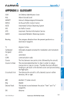
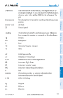
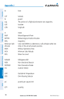
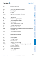
Overview GPS Navigation Additional Features Hazard Avoidance Flight Planning Appendix J Distance DME DTK The 'great circle' distance from the present position to a destination waypoint. Distance Measuring Equipment Desired Track Enroute Safe Altitude The recommended minimum altitude within ten miles left or right of the desired course on an active flight plan or directto. ESA Enroute Safe Altitude Estimated Time of The estimated time at which the aircraft should reach the Arrival destination waypoint, based upon current speed and track. Estimated Time The estimated time it takes to reach the destination waypoint Enroute from the present position, based upon current ground speed. ETA Estimated Time of Arrival ETE Estimated Time Enroute ºF degrees Fahrenheit FAA Federal Aviation Administration FAF Final Approach Fix FCC Federal Communication Commission fpm feet per minute FSS Flight Service Station ft foot/feet gal Glide Ratio, G/R gph GPS gallon(s) The estimated distance an aircraft will move forward for any given amount of lost altitude. gallons per hour Global Positioning System Appendices Index 182 Garmin aera 795/796 Pilot's Guide 190-01194-00 Rev. A
-
 1
1 -
2
-
3
-
4
-
5
-
6
-
7
-
8
-
9
-
10
-
11
-
12
-
13
-
14
-
15
-
16
-
17
-
18
-
19
-
20
-
21
-
22
-
23
-
24
-
25
-
26
-
27
-
28
-
29
-
30
-
31
-
32
-
33
-
34
-
35
-
36
-
37
-
38
-
39
-
40
-
41
-
42
-
43
-
44
-
45
-
46
-
47
-
48
-
49
-
50
-
51
-
52
-
53
-
54
-
55
-
56
-
57
-
58
-
59
-
60
-
61
-
62
-
63
-
64
-
65
-
66
-
67
-
68
-
69
-
70
-
71
-
72
-
73
-
74
-
75
-
76
-
77
-
78
-
79
-
80
-
81
-
82
-
83
-
84
-
85
-
86
-
87
-
88
-
89
-
90
-
91
-
92
-
93
-
94
-
95
-
96
-
97
-
98
-
99
-
100
-
101
-
102
-
103
-
104
-
105
-
106
-
107
-
108
-
109
-
110
-
111
-
112
-
113
-
114
-
115
-
116
-
117
-
118
-
119
-
120
-
121
-
122
-
123
-
124
-
125
-
126
-
127
-
128
-
129
-
130
-
131
-
132
-
133
-
134
-
135
-
136
-
137
-
138
-
139
-
140
-
141
-
142
-
143
-
144
-
145
-
146
-
147
-
148
-
149
-
150
-
151
-
152
-
153
-
154
-
155
-
156
-
157
-
158
-
159
-
160
-
161
-
162
-
163
-
164
-
165
-
166
-
167
-
168
-
169
-
170
-
171
-
172
-
173
-
174
-
175
-
176
-
177
-
178
-
179
-
180
-
181
-
182
-
183
-
184
-
185
-
186
-
187
-
188
-
189
-
190
-
 191
191 -
 192
192 -
 193
193 -
 194
194 -
 195
195 -
 196
196 -
 197
197 -
 198
198 -
 199
199 -
 200
200 -
 201
201 -
202
-
203
-
204
-
205
-
206
-
207
-
208
-
209
-
210
 |
 |