Garmin aera 796 Pilot's Guide - Page 52
Setting the Bug Indicator, Manually Setting a Course, Main Menu, Set CDI Scale, Automatic, 25 nm - user manual
 |
View all Garmin aera 796 manuals
Add to My Manuals
Save this manual to your list of manuals |
Page 52 highlights
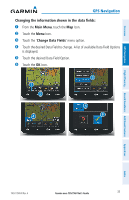
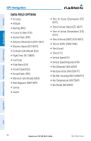
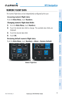
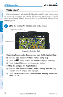
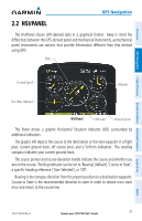
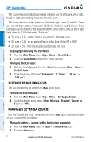
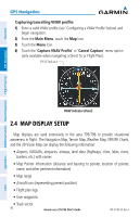
GPS Navigation Overview GPS Navigation Additional Features Hazard Avoidance Flight Planning The Course Deviation Indicator, or needle, indicates how far off course, left or right, based on its placement along the course deviation scale. The course deviation scale appears on the lower right corner of the HSI. There are four CDI Scale settings ('Automatic', '0.25 nm', '1.25 nm', and '5.00 nm'. Three factors are used to determine the distance from the center of the CDI to full left or right limits when the CDI Scale is set to 'Automatic': • CDI scale = 1.25 - within 30 nm of any airport in the active route. • CDI scale = 0.25 - on an approach leg or within 2 nm of the FAF or MAP. • CDI scale = 5.0 - if the previous two conditions do not exist. Displaying/Removing the HSI/Panel: 1) From the Main Menu, touch Map > Menu > Show/Hide... 2) Touch the Show/Hide Button in the 'Panel' datafield. Changing the CDI scale: 1) With the Panel displayed, from the 'Home' Screen, touch Map > Menu > Set CDI Scale. 2) Touch the desired CDI Scale (' Automatic', ' 0.25 nm', ' 1.25 nm', or '5.00 nm'). SETTING THE BUG INDICATOR The Bug Indicator can be set from the Map option menu. Setting the Bug Indicator: 1) From the Main Menu, touch Map > Menu > Set Bug Indicator. 2) Touch the desired menu option ('User Selected', 'Bearing', 'Course to Steer', or 'Off'). MANUALLY SETTING A COURSE Use the 'Set OBS and Hold' menu option from the Map option menu to manually set your course to the destination. Manually setting a course to the destination waypoint: 1) From the Main Menu, touch the Map or the Active FPL Icon. 2) Touch the Menu Icon. 38 Garmin aera 795/796 Pilot's Guide 190-01194-00 Rev. A Appendices Index
-
 1
1 -
2
-
3
-
4
-
5
-
6
-
7
-
8
-
9
-
10
-
11
-
12
-
13
-
14
-
15
-
16
-
17
-
18
-
19
-
20
-
21
-
22
-
23
-
24
-
25
-
26
-
27
-
28
-
29
-
30
-
31
-
32
-
33
-
34
-
35
-
36
-
37
-
38
-
39
-
40
-
41
-
42
-
43
-
44
-
45
-
46
-
 47
47 -
 48
48 -
 49
49 -
 50
50 -
 51
51 -
 52
52 -
 53
53 -
 54
54 -
 55
55 -
 56
56 -
 57
57 -
58
-
59
-
60
-
61
-
62
-
63
-
64
-
65
-
66
-
67
-
68
-
69
-
70
-
71
-
72
-
73
-
74
-
75
-
76
-
77
-
78
-
79
-
80
-
81
-
82
-
83
-
84
-
85
-
86
-
87
-
88
-
89
-
90
-
91
-
92
-
93
-
94
-
95
-
96
-
97
-
98
-
99
-
100
-
101
-
102
-
103
-
104
-
105
-
106
-
107
-
108
-
109
-
110
-
111
-
112
-
113
-
114
-
115
-
116
-
117
-
118
-
119
-
120
-
121
-
122
-
123
-
124
-
125
-
126
-
127
-
128
-
129
-
130
-
131
-
132
-
133
-
134
-
135
-
136
-
137
-
138
-
139
-
140
-
141
-
142
-
143
-
144
-
145
-
146
-
147
-
148
-
149
-
150
-
151
-
152
-
153
-
154
-
155
-
156
-
157
-
158
-
159
-
160
-
161
-
162
-
163
-
164
-
165
-
166
-
167
-
168
-
169
-
170
-
171
-
172
-
173
-
174
-
175
-
176
-
177
-
178
-
179
-
180
-
181
-
182
-
183
-
184
-
185
-
186
-
187
-
188
-
189
-
190
-
191
-
192
-
193
-
194
-
195
-
196
-
197
-
198
-
199
-
200
-
201
-
202
-
203
-
204
-
205
-
206
-
207
-
208
-
209
-
210
 |
 |
