Garmin aera 796 Pilot's Guide - Page 59
Waypoint Information, TERPs
 |
View all Garmin aera 796 manuals
Add to My Manuals
Save this manual to your list of manuals |
Page 59 highlights
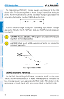
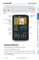
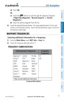
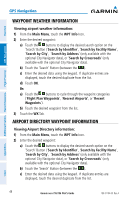
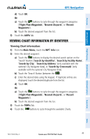
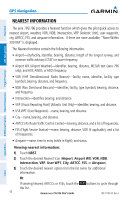
Overview GPS Navigation GPS Navigation The waypoint function allows the pilot to review airport/runway information, frequencies, Airport Directory information (if available), weather information (if available) and Terminal Procedure Charts, by touching the desired tab (Info, Freq, WX, AOPA, or TERPs). The pilot can manually enter the identifier or the aera 795/796 will choose the most appropriate identifier based on the current position and phase of flight. Waypoint Identifier Button -Waypoint Identifier -Facility Name -City/State -Waypoint Identifier Type -Fuel Available -Elevation -Region -Time Zone (UTC Offset) -Region -Wind -Name -Surface -Length/Width -Traffic Pattern -Lighting Runway Buttons Bearing/ Distance Info Tab Lat/Long Flight Planning Hazard Avoidance Additional Features Appendices Waypoint Information (Info Tab) WAYPOINT INFORMATION The following descriptions and abbreviations are used: • Usage type: Public, Military, or Private • Runway surface type: Hard, Turf, Sealed, Gravel, Dirt, Soft, Unknown, or Water • Runway lighting type: No Lights, Part Time, Full Time, Unknown, or PCL Freq (for pilot-controlled lighting) 190-01194-00 Rev. A Garmin aera 795/796 Pilot's Guide 45 Index
-
 1
1 -
2
-
3
-
4
-
5
-
6
-
7
-
8
-
9
-
10
-
11
-
12
-
13
-
14
-
15
-
16
-
17
-
18
-
19
-
20
-
21
-
22
-
23
-
24
-
25
-
26
-
27
-
28
-
29
-
30
-
31
-
32
-
33
-
34
-
35
-
36
-
37
-
38
-
39
-
40
-
41
-
42
-
43
-
44
-
45
-
46
-
47
-
48
-
49
-
50
-
51
-
52
-
53
-
 54
54 -
 55
55 -
 56
56 -
 57
57 -
 58
58 -
 59
59 -
 60
60 -
 61
61 -
 62
62 -
 63
63 -
 64
64 -
65
-
66
-
67
-
68
-
69
-
70
-
71
-
72
-
73
-
74
-
75
-
76
-
77
-
78
-
79
-
80
-
81
-
82
-
83
-
84
-
85
-
86
-
87
-
88
-
89
-
90
-
91
-
92
-
93
-
94
-
95
-
96
-
97
-
98
-
99
-
100
-
101
-
102
-
103
-
104
-
105
-
106
-
107
-
108
-
109
-
110
-
111
-
112
-
113
-
114
-
115
-
116
-
117
-
118
-
119
-
120
-
121
-
122
-
123
-
124
-
125
-
126
-
127
-
128
-
129
-
130
-
131
-
132
-
133
-
134
-
135
-
136
-
137
-
138
-
139
-
140
-
141
-
142
-
143
-
144
-
145
-
146
-
147
-
148
-
149
-
150
-
151
-
152
-
153
-
154
-
155
-
156
-
157
-
158
-
159
-
160
-
161
-
162
-
163
-
164
-
165
-
166
-
167
-
168
-
169
-
170
-
171
-
172
-
173
-
174
-
175
-
176
-
177
-
178
-
179
-
180
-
181
-
182
-
183
-
184
-
185
-
186
-
187
-
188
-
189
-
190
-
191
-
192
-
193
-
194
-
195
-
196
-
197
-
198
-
199
-
200
-
201
-
202
-
203
-
204
-
205
-
206
-
207
-
208
-
209
-
210
 |
 |
