Garmin aera 796 Pilot's Guide - Page 126
Aircraft Symbol, Displaying ChartView in Full Screen Mode
 |
View all Garmin aera 796 manuals
Add to My Manuals
Save this manual to your list of manuals |
Page 126 highlights
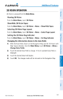
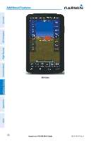
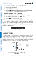
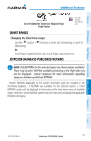
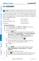
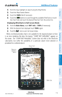
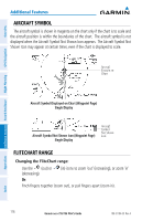
Overview GPS Navigation Additional Features Hazard Avoidance Flight Planning Additional Features 1) From the map, highlight an airport using the Map Pointer. 2) Touch the Map Feature Button. 3) Touch the TERPs Tab (if necessary). 4) Touch the buttons to cycle through the available Charts or touch the Chart Field and touch the desired Chart from the vertical list. Displaying ChartView in Full Screen Mode: 1) From the Main Menu, touch WPT Info > TERPs (if necessary). 2) With the desired chart displayed touch TERPs again. 3) Touch the icon to exit Full Screen Mode. When a terminal procedure chart is not available for the requested airport or there is an error rendering the data, the banner "CHART NOT AVAILABLE" appears on the screen. The "CHART NOT AVAILABLE" banner does not refer to the ChartView subscription, but rather the availability of a particular airport chart selection or procedure for a selected airport. Chart Not Available Banner AIRCRAFT SYMBOL The aircraft symbol is shown in magenta on the chart only if the chart is to scale and the aircraft position is within the boundaries of the chart. The aircraft symbol is not displayed when the Aircraft Symbol Not Shown Icon (X over the aircraft symbol) appears in the lower right corner. The Aircraft Symbol Not Shown Icon may appear at certain times (e.g., a loss of GPS), even if the chart is displayed to scale. Aircraft Position on Chart Appendices Index Aircraft Symbol Displayed on Chart (Waypoint Page) Single Display 112 Garmin aera 795/796 Pilot's Guide 190-01194-00 Rev. A
-
 1
1 -
2
-
3
-
4
-
5
-
6
-
7
-
8
-
9
-
10
-
11
-
12
-
13
-
14
-
15
-
16
-
17
-
18
-
19
-
20
-
21
-
22
-
23
-
24
-
25
-
26
-
27
-
28
-
29
-
30
-
31
-
32
-
33
-
34
-
35
-
36
-
37
-
38
-
39
-
40
-
41
-
42
-
43
-
44
-
45
-
46
-
47
-
48
-
49
-
50
-
51
-
52
-
53
-
54
-
55
-
56
-
57
-
58
-
59
-
60
-
61
-
62
-
63
-
64
-
65
-
66
-
67
-
68
-
69
-
70
-
71
-
72
-
73
-
74
-
75
-
76
-
77
-
78
-
79
-
80
-
81
-
82
-
83
-
84
-
85
-
86
-
87
-
88
-
89
-
90
-
91
-
92
-
93
-
94
-
95
-
96
-
97
-
98
-
99
-
100
-
101
-
102
-
103
-
104
-
105
-
106
-
107
-
108
-
109
-
110
-
111
-
112
-
113
-
114
-
115
-
116
-
117
-
118
-
119
-
120
-
 121
121 -
 122
122 -
 123
123 -
 124
124 -
 125
125 -
 126
126 -
 127
127 -
 128
128 -
 129
129 -
 130
130 -
 131
131 -
132
-
133
-
134
-
135
-
136
-
137
-
138
-
139
-
140
-
141
-
142
-
143
-
144
-
145
-
146
-
147
-
148
-
149
-
150
-
151
-
152
-
153
-
154
-
155
-
156
-
157
-
158
-
159
-
160
-
161
-
162
-
163
-
164
-
165
-
166
-
167
-
168
-
169
-
170
-
171
-
172
-
173
-
174
-
175
-
176
-
177
-
178
-
179
-
180
-
181
-
182
-
183
-
184
-
185
-
186
-
187
-
188
-
189
-
190
-
191
-
192
-
193
-
194
-
195
-
196
-
197
-
198
-
199
-
200
-
201
-
202
-
203
-
204
-
205
-
206
-
207
-
208
-
209
-
210
 |
 |
