Garmin aera 796 Pilot's Guide - Page 74
AIRSPACE, Select an FSS, Selecting and viewing nearest airspaces
 |
View all Garmin aera 796 manuals
Add to My Manuals
Save this manual to your list of manuals |
Page 74 highlights
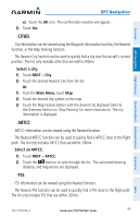
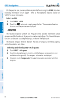
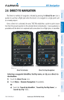
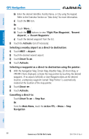
Overview GPS Navigation GPS Navigation FSS frequencies and phone numbers can also be found using the AOPA Tab when reviewing information for an airport. Refer to the Additional Features Section on 'AOPA' for more information. Select an FSS: 1) Touch NRST > FSS. 2) Touch the buttons to cycle through the list. The associated bearing, distance, and frequencies are displayed. AIRSPACE The Nearest Airspace function and Airspace Alerts provide information about airspaces and the location of the aircraft in relationship to them. The Nearest Airspace function can be used to quickly find airspaces close to the flight path. The Nearest Airspace function displays the class of airspace, controlling agency, vertical boundaries, and status. Selecting and viewing nearest airspaces: 1) Touch NRST > Airspace. 2) Touch the desired airspace from the list (the Nearest Airspaces list is not available on the ground). The airspace information is displayed. 3) If desired, touch 'Frequencies' to view frequencies associated with that airspace. Additional Features Hazard Avoidance Flight Planning Appendices Index 60 Garmin aera 795/796 Pilot's Guide 190-01194-00 Rev. A
-
 1
1 -
2
-
3
-
4
-
5
-
6
-
7
-
8
-
9
-
10
-
11
-
12
-
13
-
14
-
15
-
16
-
17
-
18
-
19
-
20
-
21
-
22
-
23
-
24
-
25
-
26
-
27
-
28
-
29
-
30
-
31
-
32
-
33
-
34
-
35
-
36
-
37
-
38
-
39
-
40
-
41
-
42
-
43
-
44
-
45
-
46
-
47
-
48
-
49
-
50
-
51
-
52
-
53
-
54
-
55
-
56
-
57
-
58
-
59
-
60
-
61
-
62
-
63
-
64
-
65
-
66
-
67
-
68
-
 69
69 -
 70
70 -
 71
71 -
 72
72 -
 73
73 -
 74
74 -
 75
75 -
 76
76 -
 77
77 -
 78
78 -
 79
79 -
80
-
81
-
82
-
83
-
84
-
85
-
86
-
87
-
88
-
89
-
90
-
91
-
92
-
93
-
94
-
95
-
96
-
97
-
98
-
99
-
100
-
101
-
102
-
103
-
104
-
105
-
106
-
107
-
108
-
109
-
110
-
111
-
112
-
113
-
114
-
115
-
116
-
117
-
118
-
119
-
120
-
121
-
122
-
123
-
124
-
125
-
126
-
127
-
128
-
129
-
130
-
131
-
132
-
133
-
134
-
135
-
136
-
137
-
138
-
139
-
140
-
141
-
142
-
143
-
144
-
145
-
146
-
147
-
148
-
149
-
150
-
151
-
152
-
153
-
154
-
155
-
156
-
157
-
158
-
159
-
160
-
161
-
162
-
163
-
164
-
165
-
166
-
167
-
168
-
169
-
170
-
171
-
172
-
173
-
174
-
175
-
176
-
177
-
178
-
179
-
180
-
181
-
182
-
183
-
184
-
185
-
186
-
187
-
188
-
189
-
190
-
191
-
192
-
193
-
194
-
195
-
196
-
197
-
198
-
199
-
200
-
201
-
202
-
203
-
204
-
205
-
206
-
207
-
208
-
209
-
210
 |
 |