Garmin aera 796 Pilot's Guide - Page 184
Proximity Waypoints, Main Menu, Tools, User WPT, Proximity, Use Identifier, Use Map, Edit Radius
 |
View all Garmin aera 796 manuals
Add to My Manuals
Save this manual to your list of manuals |
Page 184 highlights
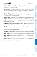
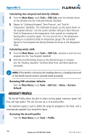
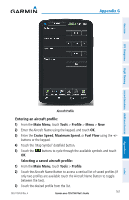
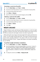
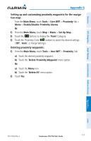
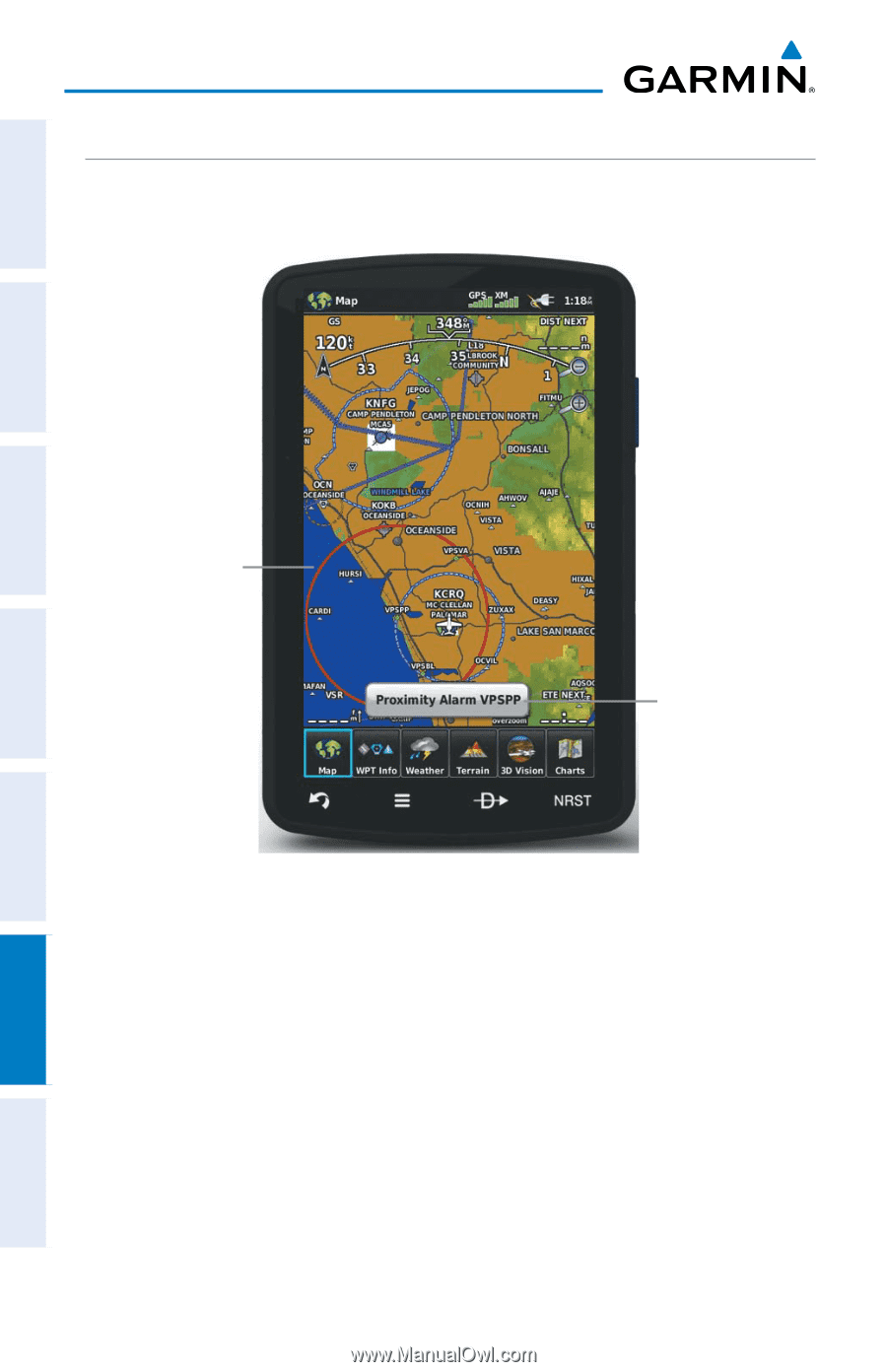
Appendix G PROXIMITY WAYPOINTS The Proximity Waypoints allows the pilot to define an alarm circle around a waypoint location. Overview GPS Navigation Additional Features Hazard Avoidance Flight Planning Proximity Circle Proximity Alarm Proximity Waypoints Defining proximity waypoints: 1) From the Main Menu, touch Tools > User WPT > Proximity Tab > Menu > New Proximity Waypoint. 2) Touch 'Use Identifier' or 'Use Map'. 3) Enter the desired identifier or pan the map. 4) Touch the newly created Proximity Waypoint, and touch 'Edit Radius'. 5) Enter the desired Radius and touch OK. 170 Garmin aera 795/796 Pilot's Guide 190-01194-00 Rev. A Appendices Index
-
 1
1 -
2
-
3
-
4
-
5
-
6
-
7
-
8
-
9
-
10
-
11
-
12
-
13
-
14
-
15
-
16
-
17
-
18
-
19
-
20
-
21
-
22
-
23
-
24
-
25
-
26
-
27
-
28
-
29
-
30
-
31
-
32
-
33
-
34
-
35
-
36
-
37
-
38
-
39
-
40
-
41
-
42
-
43
-
44
-
45
-
46
-
47
-
48
-
49
-
50
-
51
-
52
-
53
-
54
-
55
-
56
-
57
-
58
-
59
-
60
-
61
-
62
-
63
-
64
-
65
-
66
-
67
-
68
-
69
-
70
-
71
-
72
-
73
-
74
-
75
-
76
-
77
-
78
-
79
-
80
-
81
-
82
-
83
-
84
-
85
-
86
-
87
-
88
-
89
-
90
-
91
-
92
-
93
-
94
-
95
-
96
-
97
-
98
-
99
-
100
-
101
-
102
-
103
-
104
-
105
-
106
-
107
-
108
-
109
-
110
-
111
-
112
-
113
-
114
-
115
-
116
-
117
-
118
-
119
-
120
-
121
-
122
-
123
-
124
-
125
-
126
-
127
-
128
-
129
-
130
-
131
-
132
-
133
-
134
-
135
-
136
-
137
-
138
-
139
-
140
-
141
-
142
-
143
-
144
-
145
-
146
-
147
-
148
-
149
-
150
-
151
-
152
-
153
-
154
-
155
-
156
-
157
-
158
-
159
-
160
-
161
-
162
-
163
-
164
-
165
-
166
-
167
-
168
-
169
-
170
-
171
-
172
-
173
-
174
-
175
-
176
-
177
-
178
-
 179
179 -
 180
180 -
 181
181 -
 182
182 -
 183
183 -
 184
184 -
 185
185 -
 186
186 -
 187
187 -
 188
188 -
 189
189 -
190
-
191
-
192
-
193
-
194
-
195
-
196
-
197
-
198
-
199
-
200
-
201
-
202
-
203
-
204
-
205
-
206
-
207
-
208
-
209
-
210
 |
 |
Garmin aera 795/796 Pilot’s Guide
190-01194-00
Rev. A
Appendix G
170
Overview
GPS Navigation
Flight Planning
Hazard Avoidance
Additional Features
Appendices
Index
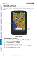
PROXIMITY WAYPOINTS
The Proximity Waypoints allows the pilot to define an alarm circle around a waypoint
location.
Proximity
Alarm
Proximity
Circle
Proximity Waypoints
Defining proximity waypoints:
1)
From the
Main Menu
, touch
Tools
>
User WPT
>
Proximity
Tab >
Menu
>
New Proximity Waypoint
.
2)
Touch '
Use Identifier
' or '
Use Map
'.
3)
Enter the desired identifier or pan the map.
4)
Touch the newly created Proximity Waypoint, and touch '
Edit Radius
'.
5)
Enter the desired Radius and touch
OK
.