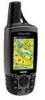
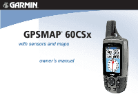
Garmin GPSMAP 60CSx Owner's Manual - Page 5

Main s, Main Menu, Creating and Using Routes - maps

Page 5 highlights

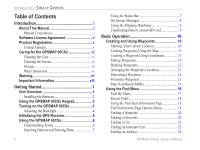
Finding an Intersection 24 Searching for a Point of Interest 24 POI Loader & Custom Points of Interest 25 Using Tracks 26 Track Profiles 30 Navigating a Saved Track 31 Creating and Using Routes 32 Creating a Route 32 Navigating a Route 33 Editing a Route 34 Vertical Profiles of routes 36 Using the Route Page Options 36 Main Pages 37 Satellite Page 38 Using the Satellite Page Options Menu 38 Using Additional Map Data 40 Changing the Zoom Range 41 Map Orientation 41 Map Page Options 41 Guidance Text 42 Setting up the Map Page 43 Measuring Distance 46 Turning Declutter On or Off 47 Restoring Defaults 47 GPSMAP 60CSx Owner's Manual Introduction > Table of Contents Compass Page 48 Using the Electronic Compass 49 Compass Page Options 51 Sight 'N Go Navigation 51 Using the Course Pointer or Bearing Pointer.........53 Data Fields 54 Altimeter Page 55 Altimeter Page Options 56 Plot Over Time or Distance 57 View Pressure or Elevation Plots 57 Zoom Ranges 58 View Points 59 View Points on Map 59 Calibrating the Altimeter 61 Changing the Data Fields 62 Trip Computer Page 63 Main Menu 64 Tracks Page 64 Route Page 65 Highway Page 65 Setup Menu Page 66 System Setup 66 Display Setup 67 Interface Setup 67 Tones Setup 70 iii

  • 1
  • 2
  • 3
  • 4
  • 5
  • 6
  • 7
  • 8
  • 9
  • 10
  • 11
  • 12
  • 13
  • 14
  • 15
  • 16
  • 17
  • 18
  • 19
  • 20
  • 21
  • 22
  • 23
  • 24
  • 25
  • 26
  • 27
  • 28
  • 29
  • 30
  • 31
  • 32
  • 33
  • 34
  • 35
  • 36
  • 37
  • 38
  • 39
  • 40
  • 41
  • 42
  • 43
  • 44
  • 45
  • 46
  • 47
  • 48
  • 49
  • 50
  • 51
  • 52
  • 53
  • 54
  • 55
  • 56
  • 57
  • 58
  • 59
  • 60
  • 61
  • 62
  • 63
  • 64
  • 65
  • 66
  • 67
  • 68
  • 69
  • 70
  • 71
  • 72
  • 73
  • 74
  • 75
  • 76
  • 77
  • 78
  • 79
  • 80
  • 81
  • 82
  • 83
  • 84
  • 85
  • 86
  • 87
  • 88
  • 89
  • 90
  • 91
  • 92
  • 93
  • 94
  • 95
  • 96
  • 97
  • 98
  • 99
  • 100
  • 101
  • 102
  • 103
  • 104
  • 105
  • 106
  • 107
  • 108
  • 109
  • 110
  • 111
  • 112
  • 113
  • 114
  • 115
  • 116

GPSMAP 60CSx Owner’s Manual
iii
I
NTRODUCTION
>
T
ABLE
OF
C
ONTENTS
Finding an Intersection
..........................................
24
Searching for a Point of Interest
............................
24
POI Loader & Custom Points of Interest
...............
25
Using Tracks
.....................................................
26
Track
Profiles
.........................................................
30
Navigating a Saved Track
......................................
31
Creating and Using Routes
.............................
32
Creating a Route
....................................................
32
Navigating a Route
...........................................
33
Editing a Route
......................................................
34
Vertical Profiles of routes
......................................
36
Using the Route Page Options
...............................
36
Main Pages
.....................................................
37
Satellite Page
....................................................
38
Using the Satellite Page Options Menu
.................
38
Using Additional Map Data
...................................
40
Changing the Zoom Range
....................................
41
Map Orientation
.....................................................
41
Map Page Options
.................................................
41
Guidance Text
........................................................
42
Setting up the Map Page
........................................
43
Measuring Distance
...............................................
46
Turning Declutter On or Off
..................................
47
Restoring Defaults
.................................................
47
Compass Page
..................................................
48
Using the Electronic Compass
...............................
49
Compass Page Options
..........................................
51
Sight ‘N Go Navigation
.........................................
51
Using the Course Pointer or Bearing Pointer
........
53
Data Fields
.............................................................
54
Altimeter Page
..................................................
55
Altimeter Page Options
.........................................
56
Plot Over Time or Distance
...................................
57
View Pressure or Elevation Plots
..........................
57
Zoom Ranges
.........................................................
58
View Points
............................................................
59
View Points on Map
..............................................
59
Calibrating the Altimeter
.......................................
61
Changing the Data Fields
......................................
62
Trip Computer Page
.........................................
63
Main Menu
......................................................
64
Tracks Page
......................................................
64
Route Page
........................................................
65
Highway Page
...................................................
65
Setup Menu Page
.............................................
66
System Setup
.........................................................
66
Display Setup
.........................................................
67
Interface Setup
.......................................................
67
Tones Setup
............................................................
70