HP Q6651C HP Designjet Z6100 Printer Series - User's Guide - Page 143
Use ESRI ArcGIS 9 to print a map
 |
View all HP Q6651C manuals
Add to My Manuals
Save this manual to your list of manuals |
Page 143 highlights
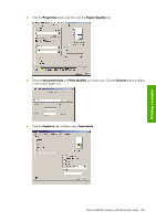
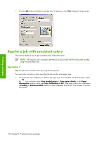
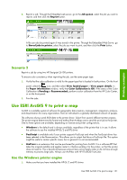
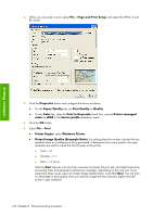
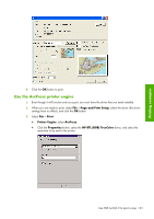
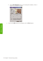
2. Reprint a job: Through the Embedded web server, go to the Job queue, select the job you want to reprint, and then click the Reprint button. Printing examples A file can also be printed again if was stored in the printer. Through the Embedded Web Server, go to Stored jobs in printer, select the job you want to print, and then click the Print button. Scenario 2 Reprint a job by using two HP Designjet Z6100 printers. To ensure color consistency when reprinting the job, use the same paper type. 1. Verify that the color calibration is valid for the paper type that is loaded in both printers. On the front panel, select the icon, and then select View loaded paper > View paper details. In the Paper information window, verify that Color Calibration is OK. If the status of the Color Calibration is Pending or Recommended, perform a color calibration from the HP Color Center, or on the front panel. 2. Print the jobs. Use ESRI ArcGIS 9 to print a map ArcGIS is a scalable system of software for geographic data creation, management, integration, analysis, and dissemination for every organization, from an individual to a globally distributed network of people. The software always sends RGB data to the printer driver. Select from several different printer engines. The printer engine determines the format and method that ArcMap uses to send the print job to the printer. One to three options are available, depending on license and printer configurations. ● Windows is the default and is always available, regardless of the printer that is in use. It allows the software to use the installed HP-GL/2 and RTL driver ● PostScript is available only if your printer supports PostScript and when the PostScript driver has been selected in the Name section. This allows you to output the file as a PostScript file. This option might be useful in certain specific cases, but in general it is not recommended. ● ArcPress is an extension that can be purchased for printing from ArcGIS. It is a software RIP that takes the original metafile and applies raster to it before sending it to the printer, so that the printer does not need to. This is beneficial because some printers cannot apply raster or do not have enough memory to process large jobs. Always use ArcPress with HP RTL (RGB) TrueColor. Use the Windows printer engine 1. Make sure that you have installed the HP-GL/2 and RTL driver. Use ESRI ArcGIS 9 to print a map 131
-
 1
1 -
2
-
3
-
4
-
5
-
6
-
7
-
8
-
9
-
10
-
11
-
12
-
13
-
14
-
15
-
16
-
17
-
18
-
19
-
20
-
21
-
22
-
23
-
24
-
25
-
26
-
27
-
28
-
29
-
30
-
31
-
32
-
33
-
34
-
35
-
36
-
37
-
38
-
39
-
40
-
41
-
42
-
43
-
44
-
45
-
46
-
47
-
48
-
49
-
50
-
51
-
52
-
53
-
54
-
55
-
56
-
57
-
58
-
59
-
60
-
61
-
62
-
63
-
64
-
65
-
66
-
67
-
68
-
69
-
70
-
71
-
72
-
73
-
74
-
75
-
76
-
77
-
78
-
79
-
80
-
81
-
82
-
83
-
84
-
85
-
86
-
87
-
88
-
89
-
90
-
91
-
92
-
93
-
94
-
95
-
96
-
97
-
98
-
99
-
100
-
101
-
102
-
103
-
104
-
105
-
106
-
107
-
108
-
109
-
110
-
111
-
112
-
113
-
114
-
115
-
116
-
117
-
118
-
119
-
120
-
121
-
122
-
123
-
124
-
125
-
126
-
127
-
128
-
129
-
130
-
131
-
132
-
133
-
134
-
135
-
136
-
137
-
 138
138 -
 139
139 -
 140
140 -
 141
141 -
 142
142 -
 143
143 -
 144
144 -
 145
145 -
 146
146 -
 147
147 -
 148
148 -
149
-
150
-
151
-
152
-
153
-
154
-
155
-
156
-
157
-
158
-
159
-
160
-
161
-
162
-
163
-
164
-
165
-
166
-
167
-
168
-
169
-
170
-
171
-
172
-
173
-
174
-
175
-
176
-
177
-
178
-
179
-
180
-
181
-
182
-
183
-
184
-
185
-
186
-
187
-
188
-
189
-
190
-
191
-
192
-
193
-
194
-
195
-
196
-
197
-
198
-
199
-
200
-
201
-
202
-
203
-
204
-
205
-
206
-
207
-
208
-
209
-
210
-
211
-
212
-
213
-
214
-
215
-
216
-
217
-
218
-
219
-
220
-
221
-
222
-
223
-
224
-
225
-
226
-
227
-
228
-
229
-
230
-
231
-
232
 |
 |
